ISS061-E-14342
| NASA Photo ID | ISS061-E-14342 |
| Focal Length | 95mm |
| Date taken | 2019.10.26 |
| Time taken | 09:45:46 GMT |
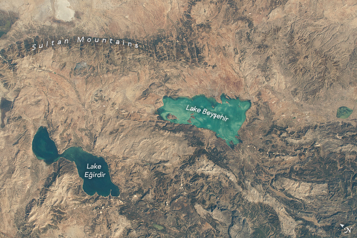


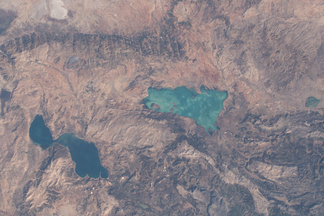
Photo center point: 37.9° N, 31.4° E
Photo center point by machine learning:
Country or Geographic Name: | TURKEY |
Features: | LAKE BEYSEHIR, LAKE EGIRDIR |
| Features Found Using Machine Learning: | |
Cloud Cover Percentage: | 10 (1-10)% |
Sun Elevation Angle: | 38° |
Sun Azimuth: | 179° |
Camera: | Nikon D5 Electronic Still Camera |
Focal Length: | 95mm |
Camera Tilt: | 44 degrees |
Format: | 5568E: 5568 x 3712 pixel CMOS sensor, 35.9 x 23.9 mm, total pixels: 21.33 million, Nikon FX format |
Film Exposure: | |
| Additional Information | |
| Width | Height | Annotated | Cropped | Purpose | Links |
|---|---|---|---|---|---|
| 720 pixels | 480 pixels | Yes | No | NASA's Earth Observatory web site | Download Image |
| 5568 pixels | 3712 pixels | No | No | Download Image | |
| 640 pixels | 427 pixels | No | No | Download Image |
Two of the largest freshwater lakes in Turkey are featured in this photograph, taken by an astronaut from the International Space Station (ISS). Lake Beysehir (//fis.freshwatertools.eu/index.php/beysehir.html#beysehir_significance) and Lake Egirdir are situated in the Turkish Lakes Region, a highly active tectonic area on the Anatolia Plateau.
There are several shallow lakes in the region that are replenished through precipitation, limestone springs and streams, and runoff from the Sultan Mountains. The water levels of these lakes change seasonally, mainly due to their usage as a drinking water source and as irrigation for local agriculture. As water levels drop, the light-colored limestone sediments on the lake beds become more apparent, giving the water a lighter color (as with Lake Beysehir above).
Lake Beysehir and Lake Egirdir have been designated by global conservation organizations as important bird and plant habitats. At least 181 bird species use the shorelines and small islands within the lakes as nesting and breeding grounds.
