ISS059-E-35737

| NASA Photo ID | ISS059-E-35737 |
| Focal Length | 210mm |
| Date taken | 2019.04.25 |
| Time taken | 20:08:11 GMT |
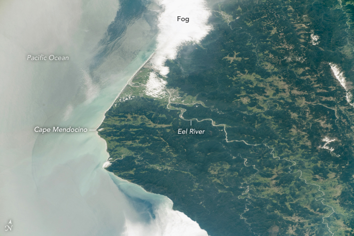

Photo center point: 40.5° N, 124.0° W
Photo center point by machine learning: 40.45° N, 124.10° W

Country or Geographic Name: | USA-CALIFORNIA |
Features: | EEL RIVER, SUN GLINT, EUREKA, HUMBOLDT, BLAKE MOUNTAIN |
| Features Found Using Machine Learning: | |
Cloud Cover Percentage: | 10 (1-10)% |
Sun Elevation Angle: | 58° |
Sun Azimuth: | 174° |
Camera: | Nikon D5 Electronic Still Camera |
Focal Length: | 210mm |
Camera Tilt: | 53 degrees |
Format: | 5568E: 5568 x 3712 pixel CMOS sensor, 35.9 x 23.9 mm, total pixels: 21.33 million, Nikon FX format |
Film Exposure: | |
| Additional Information | |
| Width | Height | Annotated | Cropped | Purpose | Links |
|---|---|---|---|---|---|
| 720 pixels | 480 pixels | Yes | Yes | NASA's Earth Observatory web site | Download Image |
| 5568 pixels | 3712 pixels | No | No | Download Image | |
| 640 pixels | 427 pixels | No | No | Download Image |
While orbiting over the U.S. West Coast, an astronaut on the International Space Station looked south to take this photo of Humboldt County in northern California. Forests make up much of the dark green landscapes. Lighter green areas along the coastal river estuaries are wetlands. The Eel River flows through mountainous topography and meets the Pacific Ocean near Eureka, CA.
Eureka, located just north of the Eel River outlet (bottom of image), is obscured by its notorious fog. The climate of Humboldt County is persistently wet with temperatures rarely exceeding 80AdegF (~27 degrees C) year round. The area's rainy season is during the winter, receiving about 75% of its annual rainfall from November through March. Thick summer fog brings essential moisture to the famous redwood forests during relatively drier summer months.
The regional airport here was originally built as a Naval Air Station during World War II to test military defogging equipment (//www.leginfo.ca.gov/pub/97-98/bill/sen/sb_0001-0050/sjr_12_bill_19970423_chaptered.html). Later the runways were used for military experiments for low visibility landings and the airport is still used today for commercial flights.
Large faults run through Cape Mendocino and off the coastline. Humboldt County is subject to high seismic risk due to its close proximity to a triple junction where the Pacific, North American and Gorda Plates meet just offshore. Earthquakes here put the coastline at risk for tsunamis and landslide hazards.
References
- U.S. Department of Commerce, National Oceanic and Atmospheric Administration, National Weather Service. NOAA Technical Memorandum, NWS WR-252 Climate of Eureka, California (1998). Accessed May 23, 2019.
- National Aeronautics and Space Administration. NASA Contractor Report 3255, Fog Dispersion (1980). Accessed May 23, 2019.
