ISS056-E-77502

| NASA Photo ID | ISS056-E-77502 |
| Focal Length | 145mm |
| Date taken | 2018.07.05 |
| Time taken | 08:16:06 GMT |
4928 x 2768 pixels 720 x 480 pixels 4928 x 2768 pixels 640 x 359 pixels
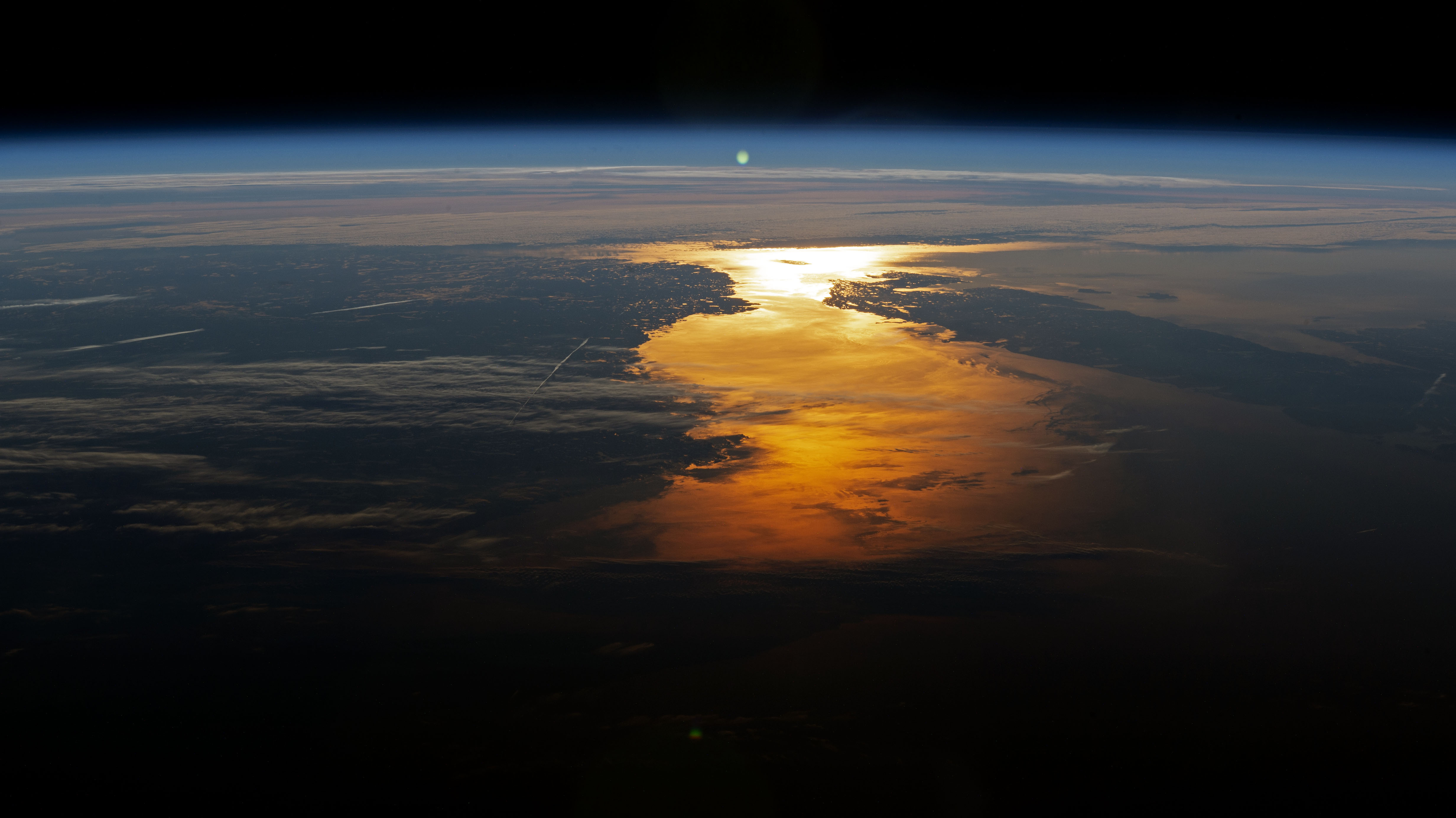
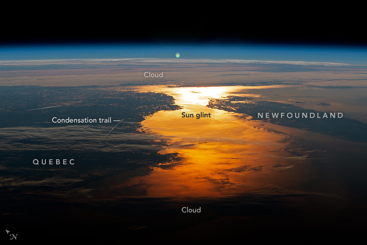
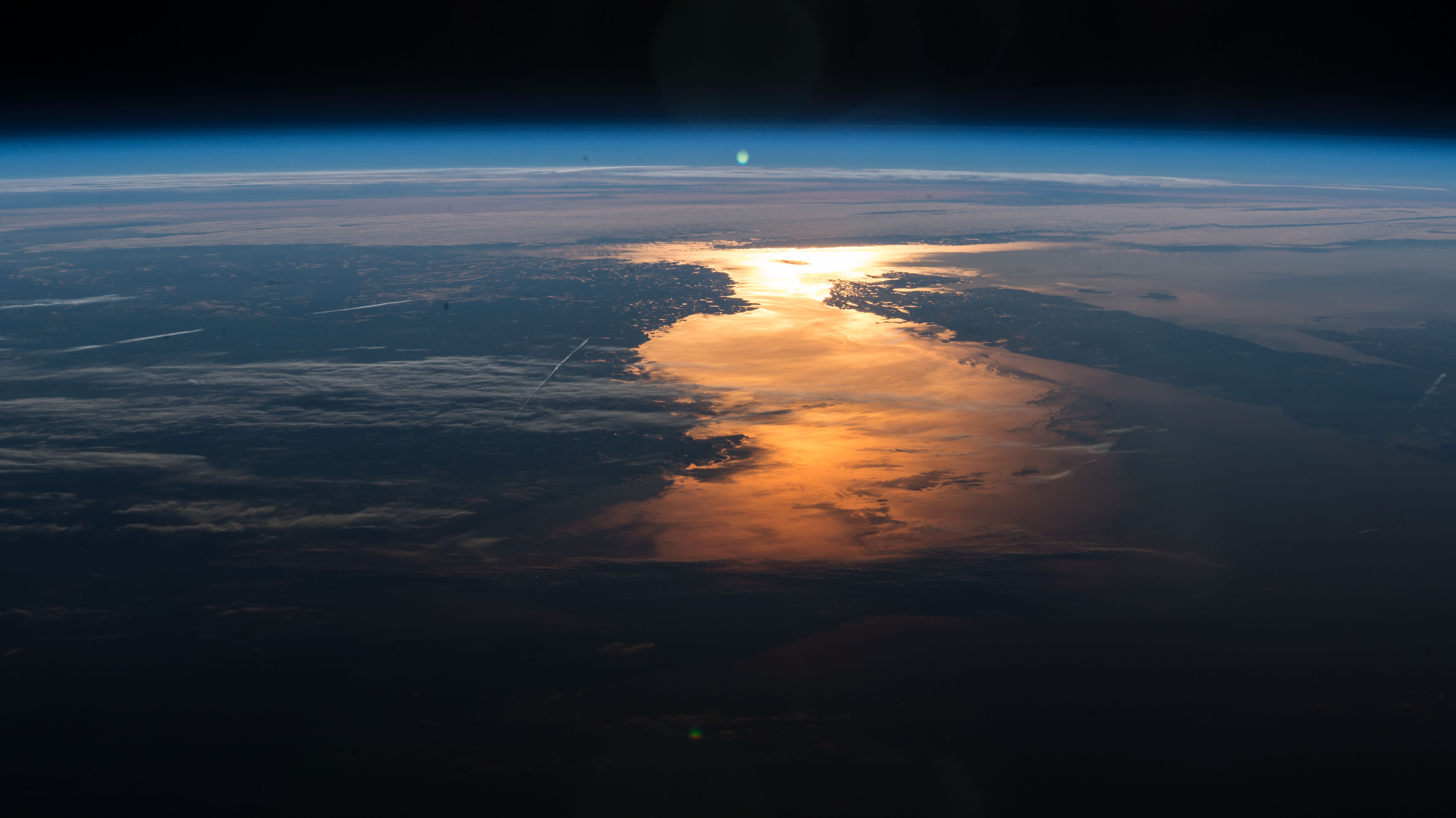
Photo center point: 50.7° N, 59.2° W
Photo center point by machine learning:
Country or Geographic Name: | CANADA-Q |
Features: | PAN- GULF OF ST LAWRENCE, NEWFOUNDLAND, SUN GLINT |
| Features Found Using Machine Learning: | PAN- |
Cloud Cover Percentage: | 50 (26-50)% |
Sun Elevation Angle: | -10° |
Sun Azimuth: | 46° |
Camera: | Nikon D4 Electronic Still Camera |
Focal Length: | 145mm |
Camera Tilt: | High Oblique |
Format: | 4928E: 4928 x 3280 pixel CMOS sensor, 36.0mm x 23.9mm, total pixels: 16.6 million, Nikon FX format |
Film Exposure: | |
| Additional Information | Image acquired by ISS External High Definition Camera |
| Width | Height | Annotated | Cropped | Purpose | Links |
|---|---|---|---|---|---|
| 4928 pixels | 2768 pixels | No | No | NASA's Earth Observatory web site | Download Image |
| 720 pixels | 480 pixels | Yes | Yes | NASA's Earth Observatory web site | Download Image |
| 4928 pixels | 2768 pixels | No | No | Download Image | |
| 640 pixels | 359 pixels | No | No | Download Image |
An astronaut aboard the International Space Station (ISS) focused a camera lens on the Sun's reflection point, roughly 1700 kilometers (1050 miles) to the northeast of the spacecraft's position over Massachusetts at the time this image was taken. This oblique photograph shows the horizon and coastline of the Canadian provinces of Newfoundland and Labrador, with Quebec further inland.
There was only a narrow window of opportunity for this sunglint photograph. The Sun's reflection was moving across the narrows (separating the island of Newfoundland and mainland Labrador) and in a break between two cloud banks. Clouds are so common in this part of the world that images of the region are not often acquired from the ISS.
From their altitude in the space station, the astronauts were seeing an early sunrise, which was timed at 4:41 a.m. at Goose Bay in Labrador on the day this photograph was taken. The Sun would only rise at 5:20 a.m. for people on the ground in Massachusetts directly below the spacecraft.
Three airplane condensation trails appear in the left half of the image, and another is visible on the right margin. All of them are oriented along the shortest air route to Europe (over eastern Canada), which is one of the most densely travelled air routes between North America and Europe.
