ISS056-E-156989
| NASA Photo ID | ISS056-E-156989 |
| Focal Length | 122mm |
| Date taken | 2018.08.23 |
| Time taken | 21:20:35 GMT |


Photo center point: 18.8° S, 62.6° W
Photo center point by machine learning:
Country or Geographic Name: | BOLIVIA |
Features: | SAND, PARAPETI RIVER, RIO GRANDE, SANTA CRUZ DE LA SIERRA |
| Features Found Using Machine Learning: | |
Cloud Cover Percentage: | 10 (1-10)% |
Sun Elevation Angle: | 7° |
Sun Azimuth: | 283° |
Camera: | Nikon D5 Electronic Still Camera |
Focal Length: | 122mm |
Camera Tilt: | High Oblique |
Format: | 5568E: 5568 x 3712 pixel CMOS sensor, 35.9 x 23.9 mm, total pixels: 21.33 million, Nikon FX format |
Film Exposure: | |
| Additional Information | |
| Width | Height | Annotated | Cropped | Purpose | Links |
|---|---|---|---|---|---|
| 720 pixels | 480 pixels | Yes | Yes | NASA's Earth Observatory web site | Download Image |
| 5568 pixels | 3712 pixels | No | No | Download Image | |
| 640 pixels | 427 pixels | No | No | Download Image |
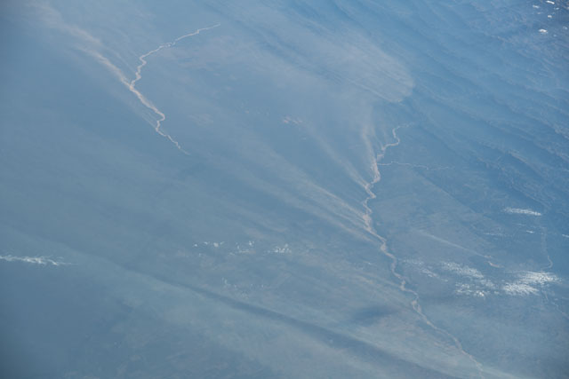
A thin veil of dust blows across the low-lying region south of the Parapeti and Guapay (Grande) Rivers in southern Bolivia. An astronaut shot this photograph as strong winds blew parallel to the Andean foothills over a dried riverbed, creating streaks of airborne sediment. While the dust obscures much of the land below, blocky plots of deforestation and agricultural development are visible along the rivers through the haze.
The winter season in the Bolivian lowlands - May to October - is often hot and dry. With little to no rainfall, the rivers dry up and become vulnerable to aeolian processes such as wind erosion and transport of sediments as dust plumes. Strong winds can keep the sediment aloft for long periods of time, leading to transport and deposition further to the south.
The Andean foothills act as a barrier, preventing the airborne dust from traveling west. However, there is little need for it on the other side of the mountains. To the west of the area in this image, the large salt flats of Bolivia provide material for far greater dust storms.
