ISS055-E-59361
| NASA Photo ID | ISS055-E-59361 |
| Focal Length | 28mm |
| Date taken | 2018.05.07 |
| Time taken | 07:28:21 GMT |

Cloud masks available for this image:
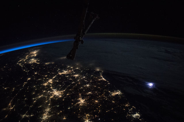
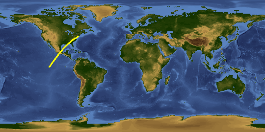
Spacecraft nadir point: 31.7° N, 85.7° W
Photo center point: 34.5° N, 77.0° W
Photo center point by machine learning:
Photo center point: 34.5° N, 77.0° W
Photo center point by machine learning:
Nadir to Photo Center: East
Spacecraft Altitude: 215 nautical miles (398km)
Country or Geographic Name: | USA-NORTH CAROLINA |
Features: | PAN- LIGHTNING, ATLANTIC OCEAN, SAVANNAH AT NIGHT, CHARLESTON AT NIGHT, AUGUSTA AT NIGHT, COLUMBIA AT NIGHT, MYRTLE BEACH AT NIGHT, WILMINGTON AT NIGHT, FLORENCE AT NIGHT, FAYETTEVILLE AT NIGHT |
| Features Found Using Machine Learning: | LIGHTNING, PAN- |
Cloud Cover Percentage: | 50 (26-50)% |
Sun Elevation Angle: | -35° |
Sun Azimuth: | 32° |
Camera: | Nikon D5 Electronic Still Camera |
Focal Length: | 28mm |
Camera Tilt: | High Oblique |
Format: | 5568E: 5568 x 3712 pixel CMOS sensor, 35.9 x 23.9 mm, total pixels: 21.33 million, Nikon FX format |
Film Exposure: | |
| Additional Information | |
This photo is one of the photos used to create this time-lapse video:
| Width | Height | Annotated | Cropped | Purpose | Links |
|---|---|---|---|---|---|
| 5568 pixels | 3712 pixels | No | No | Download Image | |
| 640 pixels | 427 pixels | No | No | Download Image |
Download Packaged File
Download a Google Earth KML for this Image
View photo footprint information
Download a GeoTIFF for this photo
Georeferenced by human interaction - exported 2018-08-16-191321-UTCAn explanation of the georeference file(s) above
Image Caption: none
