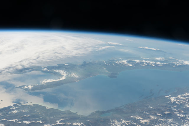
ISS050-E-71119
| NASA Photo ID | ISS050-E-71119 |
| Focal Length | 70mm |
| Date taken | 2017.04.09 |
| Time taken | 13:25:40 GMT |


Spacecraft nadir point: 42.8° N, 27.8° E
Photo center point: 41.4° N, 13.9° E
Photo center point by machine learning:
Photo center point: 41.4° N, 13.9° E
Photo center point by machine learning:
Nadir to Photo Center: West
Spacecraft Altitude: 213 nautical miles (394km)
Country or Geographic Name: | ITALY |
Features: | SANT'AMBROGIO SUL GARIGLIANO, SANT'APOLLINARE, ROCCA D'EVANDRO, SANT'ANDREA DEL GARIGLIANO |
| Features Found Using Machine Learning: | PAN- |
Cloud Cover Percentage: | 50 (26-50)% |
Sun Elevation Angle: | 35° |
Sun Azimuth: | 245° |
Camera: | Nikon D4 Electronic Still Camera |
Focal Length: | 70mm |
Camera Tilt: | High Oblique |
Format: | 4928E: 4928 x 3280 pixel CMOS sensor, 36.0mm x 23.9mm, total pixels: 16.6 million, Nikon FX format |
Film Exposure: | |
| Additional Information | |
| Width | Height | Annotated | Cropped | Purpose | Links |
|---|---|---|---|---|---|
| 4928 pixels | 3280 pixels | No | No | Download Image | |
| 640 pixels | 426 pixels | No | No | Download Image |
Download Packaged File
Download a Google Earth KML for this Image
View photo footprint information
Download a GeoTIFF for this photo
Image Caption: CATALOGED BY UT-BROWNSVILLE/STARGATE
