ISS050-E-29783
| NASA Photo ID | ISS050-E-29783 |
| Focal Length | 240mm |
| Date taken | 2016.12.29 |
| Time taken | 07:11:43 GMT |
1000 x 666 pixels 4928 x 3280 pixels 720 x 480 pixels 4928 x 3280 pixels 640 x 426 pixels
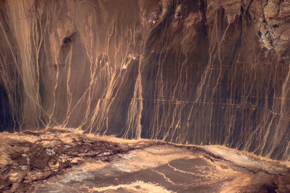

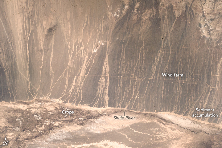


Photo center point: 40.7° N, 95.3° E
Photo center point by machine learning: 40.68° N, 95.26° E

Country or Geographic Name: | CHINA |
Features: | WIND FARMS, MAJIAMIAO, AGR., GOBI DES., DRAINAGE PATTERNS |
| Features Found Using Machine Learning: | |
Cloud Cover Percentage: | 10 (1-10)% |
Sun Elevation Angle: | 22° |
Sun Azimuth: | 203° |
Camera: | Nikon D4 Electronic Still Camera |
Focal Length: | 240mm |
Camera Tilt: | 10 degrees |
Format: | 4928E: 4928 x 3280 pixel CMOS sensor, 36.0mm x 23.9mm, total pixels: 16.6 million, Nikon FX format |
Film Exposure: | |
| Additional Information | |
| Width | Height | Annotated | Cropped | Purpose | Links |
|---|---|---|---|---|---|
| 1000 pixels | 666 pixels | Yes | No | Earth From Space collection | Download Image |
| 4928 pixels | 3280 pixels | No | No | NASA's Earth Observatory web site | Download Image |
| 720 pixels | 480 pixels | Yes | No | NASA's Earth Observatory web site | Download Image |
| 4928 pixels | 3280 pixels | No | No | Download Image | |
| 640 pixels | 426 pixels | No | No | Download Image |
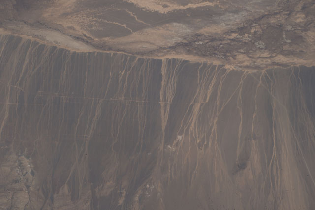
An astronaut aboard the International Space Station captured this photograph of drainage patterns on the southwestern end of the Gobi Desert in China's Gansu Province. The desert landscape - part of the Hexi (or Gansu) Corridor route along the historical Silk Road - is low in elevation, generally flat, and surrounded by mountains and rolling hills.
The foothills of the Tien Shan mountains lie to the north of this scene. As temperatures warm in the springtime, snow melt from the higher elevations flows down into streams, forming narrow alluvial fans. The water carries sand, silt, and clay that accumulate at the mouths of the streams. These sediments are then available for further transport by larger valley rivers such as the Shule.
The grid pattern superimposed on the basin is part of the Gansu Wind Farm Project. Narrow roads mark the paths between dozens of wind turbines. Currently China is the largest emitter of greenhouse gases, and the wind farms are part of an effort to reduce carbon emissions and to harness cleaner energy.
Most of the agriculture in this region follows along the Hexi Corridor. Several small towns skirt the Shule River, diverting water for cultivation of wool, tobacco, and a variety of grain and fruit crops.
