ISS050-E-29655

| NASA Photo ID | ISS050-E-29655 |
| Focal Length | 45mm |
| Date taken | 2017.01.10 |
| Time taken | 07:31:43 GMT |
1000 x 666 pixels 540 x 360 pixels 4928 x 3280 pixels 720 x 480 pixels 4928 x 3280 pixels 640 x 426 pixels
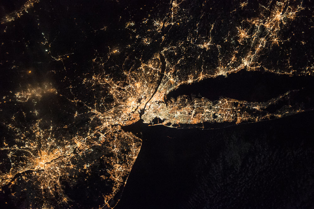
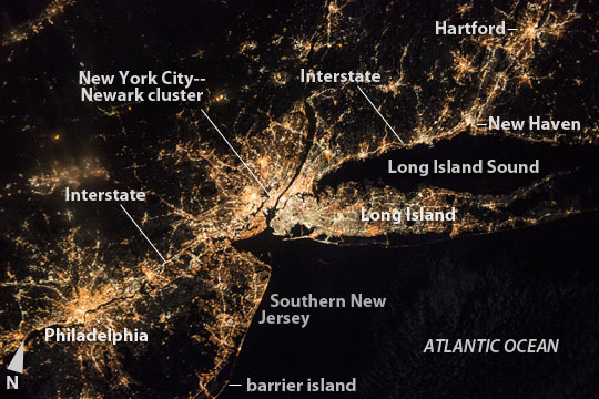
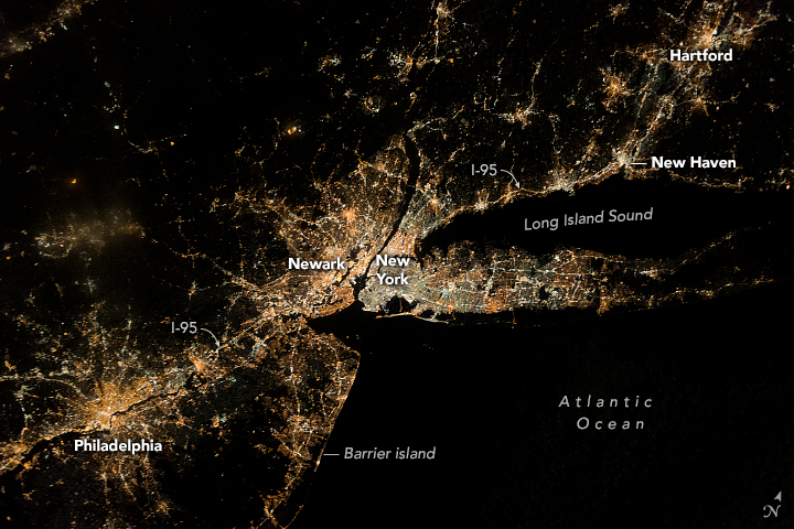

Photo center point: 40.5° N, 73.5° W
Photo center point by machine learning:
Country or Geographic Name: | USA-NEW YORK |
Features: | PHILADELPHIA, NEW YORK, HARTFORD AT NIGHT |
| Features Found Using Machine Learning: | NEW YORK |
Cloud Cover Percentage: | 10 (1-10)% |
Sun Elevation Angle: | -53° |
Sun Azimuth: | 70° |
Camera: | Nikon D4 Electronic Still Camera |
Focal Length: | 45mm |
Camera Tilt: | 20 degrees |
Format: | 4928E: 4928 x 3280 pixel CMOS sensor, 36.0mm x 23.9mm, total pixels: 16.6 million, Nikon FX format |
Film Exposure: | |
| Additional Information | |
| Width | Height | Annotated | Cropped | Purpose | Links |
|---|---|---|---|---|---|
| 1000 pixels | 666 pixels | No | No | Earth From Space collection | Download Image |
| 540 pixels | 360 pixels | Yes | No | Earth From Space collection | Download Image |
| 4928 pixels | 3280 pixels | No | No | NASA's Earth Observatory web site | Download Image |
| 720 pixels | 480 pixels | Yes | Yes | NASA's Earth Observatory web site | Download Image |
| 4928 pixels | 3280 pixels | No | No | Download Image | |
| 640 pixels | 426 pixels | No | No | Download Image |
An astronaut aboard the International Space Station (ISS) centered this night photograph on the most brilliant group of lights in the northeast US: New York city and Newark, NJ (at image center) lie at the center of the string of city lights stretching from a distance of 325 km (200 miles) from Philadelphia, PA (at image lower left) to Hartford, CT (top right). The characteristic shape of Long Island, during night and daylight passes may be the most recognizable feature to an astronaut.
Lesser night-light intensity parallels lower population densities--well illustrated on Long Island--where the progressive decline of population density away from cores of the largest cities. This is a phenomenon well-known to urban geographers.
Yet lower population densities appear in the southern counties of New Jersey in a dispersed settlement pattern that stretches 60 miles to Barnegat Bay (at image lower left). Here the barrier island is defined by narrow shoreline developments (at image lower left margin). Rural areas (at image top left) with the lowest populations have almost as few lights as the Atlantic Ocean (at image lower right).
The network thin lines of highways and main roads--difficult to see in daylight images--radiate outward from the major cities (Philadelphia is the best example in this view). One of the brightest lines is Interstate 95 that crosses the entire image, from a point west of Philadelphia, through New York--where it is drowned out New York city lights--and along the coast of Long Island Sound to New Haven and further east.
Astronauts choose a lens for the size of the area they want to capture in an image. This image was taken with a short (45 mm) lens. It shows the difference in area compared with that captured by a long lens (800 mm)--as used for example, for images of Manhattan and Brooklyn.
