ISS049-E-41356
| NASA Photo ID | ISS049-E-41356 |
| Focal Length | 1150mm |
| Date taken | 2016.10.20 |
| Time taken | 15:12:26 GMT |
4928 x 3280 pixels 720 x 480 pixels 4928 x 3280 pixels 640 x 426 pixels
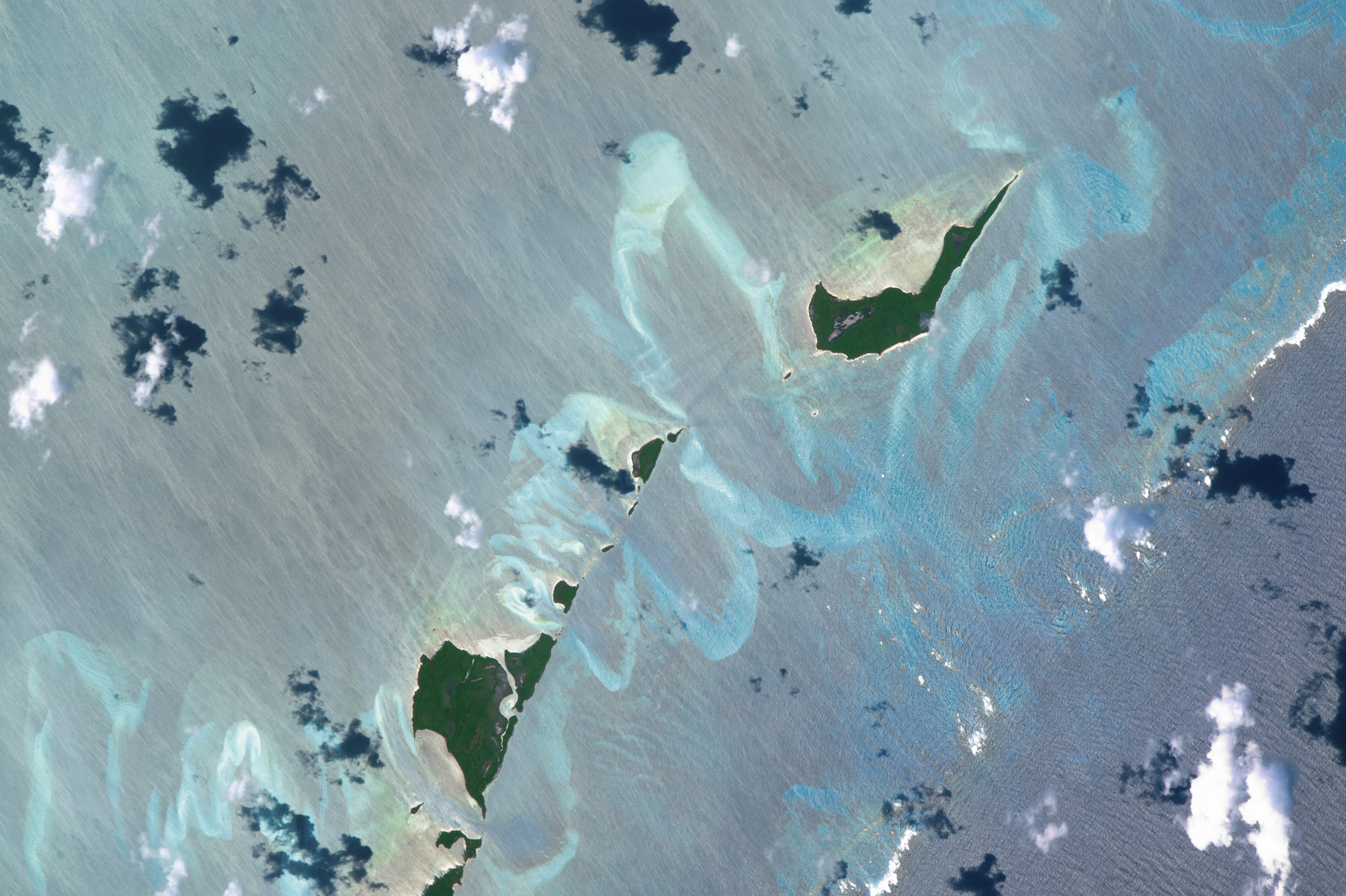


Photo center point: 27.1° N, 78.1° W
Photo center point by machine learning: 27.10° N, 78.06° W

Country or Geographic Name: | BAHAMAS |
Features: | LITTLE BAHAMA BANK, STRANGERS CAY |
| Features Found Using Machine Learning: | |
Cloud Cover Percentage: | 10 (1-10)% |
Sun Elevation Angle: | 42° |
Sun Azimuth: | 142° |
Camera: | Nikon D4 Electronic Still Camera |
Focal Length: | 1150mm |
Camera Tilt: | 33 degrees |
Format: | 4928E: 4928 x 3280 pixel CMOS sensor, 36.0mm x 23.9mm, total pixels: 16.6 million, Nikon FX format |
Film Exposure: | |
| Additional Information | |
| Width | Height | Annotated | Cropped | Purpose | Links |
|---|---|---|---|---|---|
| 4928 pixels | 3280 pixels | No | No | NASA's Earth Observatory web site | Download Image |
| 720 pixels | 480 pixels | Yes | No | NASA's Earth Observatory web site | Download Image |
| 4928 pixels | 3280 pixels | No | No | Download Image | |
| 640 pixels | 426 pixels | No | No | Download Image |
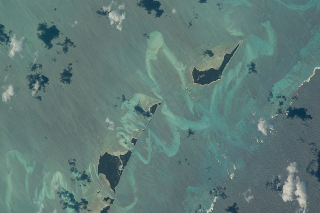
This detailed image, taken by an astronaut aboard the International Space Station with a long lens, is one of the favorite places for spacefarers to photograph. The Bahama Islands, just east of the US's Florida Peninsula, are one of the most recognizable places on Earth for astronauts because of large areas of shallow sea, known as banks, that appear as an unusual, and attractive light blue (at image center and left). The straight edge of the Little Bahama Bank shown here in the northern Bahamas is marked by the straight line of a coral reef. A thin line of white breakers (at image right and lower margins) is breaking on the seaward edge of the reef. The sea floor rapidly deepens north of this line, expressed in the image as a zone that appears as a darker blue (at image lower right).
This long-lens view of the Little Bahama Bank shows all kinds of detail in the shallow water. The brightest swirls are shelly sands molded into sweeping shapes that give a strong sense of the flow of water moved repeatedly onto and off the bank (lower left to upper right). The largest sand feature (U-shape at image center) lies opposite the widest break in the coral reef where the tidal flow is strongest. The gap in the line of white breakers shows the opening. The small island known as Strangers Cay is 3.6 km (2.25 mi.) long, giving an idea of the large distances on the sea floor affected by the tides on this shallow bank. Other black shapes are the shadows of clouds (at image top left).
Regular patterns of swells appear in the deeper water (at image lower right). The quieter shallow water in the center of the image, protected from the open sea by the reef, is streaked by a brisk wind from the northeast (bottom of the image) on the day this view was taken.
