ISS046-E-3395
| NASA Photo ID | ISS046-E-3395 |
| Focal Length | 1150mm |
| Date taken | 2015.12.28 |
| Time taken | 16:43:26 GMT |
1000 x 666 pixels 540 x 360 pixels 4928 x 3280 pixels 720 x 480 pixels 4928 x 3280 pixels 640 x 426 pixels
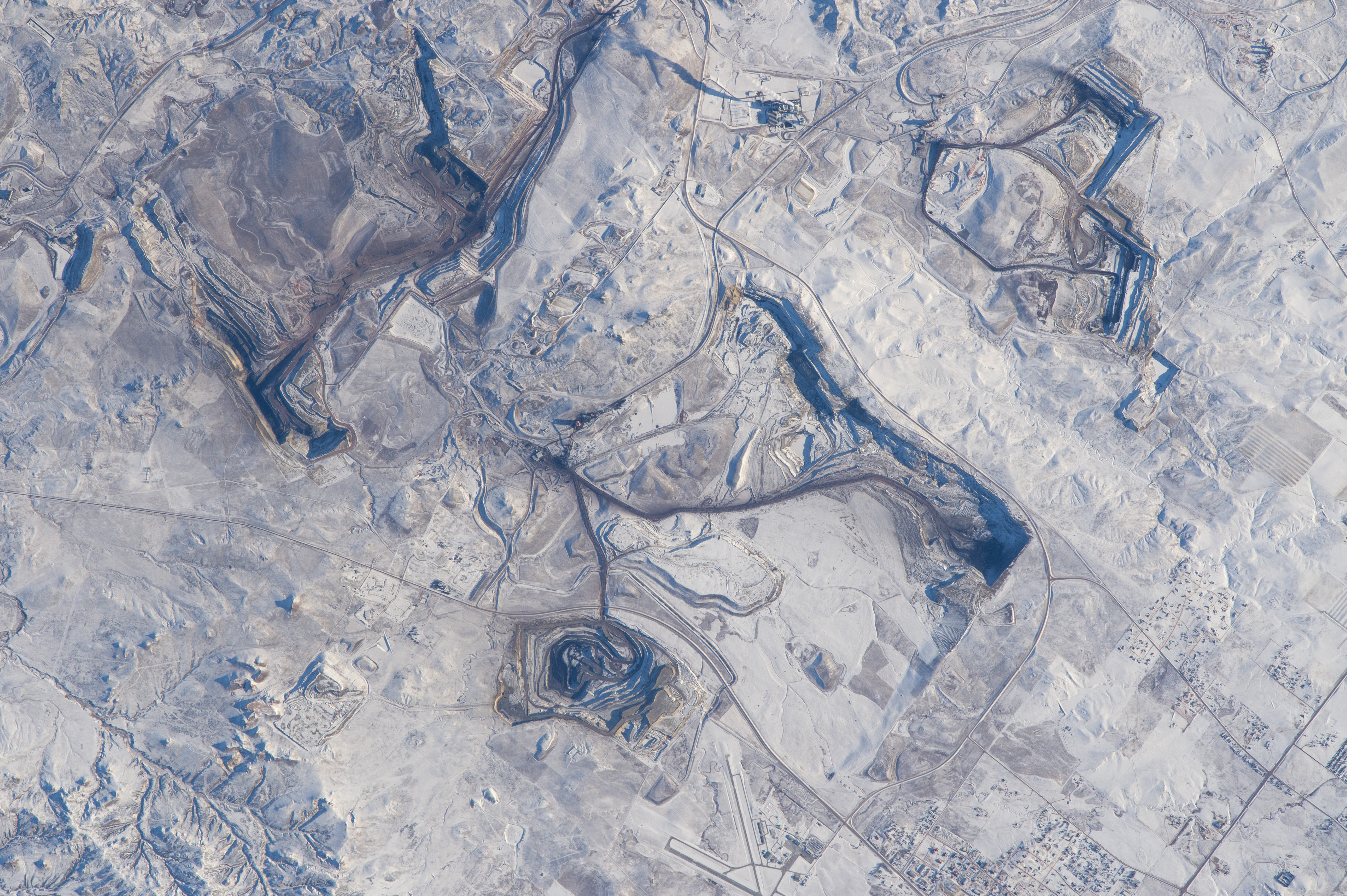


Photo center point: 44.4° N, 105.5° W
Photo center point by machine learning:
Country or Geographic Name: | USA-WYOMING |
Features: | OPEN CAST COAL MINES, GILLETTE, SNOW |
| Features Found Using Machine Learning: | |
Cloud Cover Percentage: | 0 (no clouds present) |
Sun Elevation Angle: | 16° |
Sun Azimuth: | 148° |
Camera: | Nikon D4 Electronic Still Camera |
Focal Length: | 1150mm |
Camera Tilt: | 15 degrees |
Format: | 4928E: 4928 x 3280 pixel CMOS sensor, 36.0mm x 23.9mm, total pixels: 16.6 million, Nikon FX format |
Film Exposure: | |
| Additional Information | |
| Width | Height | Annotated | Cropped | Purpose | Links |
|---|---|---|---|---|---|
| 1000 pixels | 666 pixels | No | No | Earth From Space collection | Download Image |
| 540 pixels | 360 pixels | Yes | No | Earth From Space collection | Download Image |
| 4928 pixels | 3280 pixels | No | No | NASA's Earth Observatory web site | Download Image |
| 720 pixels | 480 pixels | Yes | No | NASA's Earth Observatory web site | Download Image |
| 4928 pixels | 3280 pixels | No | No | Download Image | |
| 640 pixels | 426 pixels | No | No | Download Image |
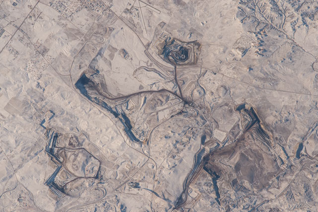
Orbiting over the Pacific Ocean towards the west coast of the US, an astronaut aboard the International Space Station took this detailed image using the longest lens available (1150 mm) on the Space Station--camera, lens and teleconverter weigh 13.4 lbs (6.24 kg) on the ground, but nothing in the weightless environment aboard the ISS, allowing freer handling by the astronaut. The image shows angular gashes in the snow-covered landscape of northeastern Wyoming. The features that caught the astronaut's eye are the open-cast pits of the several coal mines that operate out of the small town of Gillette, in a region known as the Powder River Basin, situated between the Bighorn Mountains and the Black Hills. The Powder River Basin is now the major source of US low-sulfur coal, making Wyoming the largest coal-producer in the US. With other mines (not shown in this image), the county where Gillette is situated has the highest average income in the state of Wyoming--although employment in the energy industry has started to decline slightly in the last few years.
The outskirts of Gillette appear at image lower right. The coal lies at very shallow depth, making it economic to mine. The steep walls of the overlying rocks cast strong shadows in this snowy scene. Wind distributes coal dust so that the pits appear much darker, especially the largest pit in the view (image upper left). For scale, the longer arm of the Gillette airport (lower margin center) measures 0.9 miles (1.43 km). A summer view of another coal mine nearby in the arid landscapes of the Powder River Basin can be seen here.
