ISS045-E-56257

| NASA Photo ID | ISS045-E-56257 |
| Focal Length | 1150mm |
| Date taken | 2015.10.12 |
| Time taken | 02:24:52 GMT |
Resolutions offered for this image:
1000 x 666 pixels 540 x 360 pixels 4928 x 3280 pixels 720 x 480 pixels 4928 x 3280 pixels 640 x 426 pixels
1000 x 666 pixels 540 x 360 pixels 4928 x 3280 pixels 720 x 480 pixels 4928 x 3280 pixels 640 x 426 pixels

Spacecraft nadir point: 17.4° S, 149.6° E
Photo center point: 19.7° S, 149.2° E
Photo center point by machine learning:
Photo center point: 19.7° S, 149.2° E
Photo center point by machine learning:
Nadir to Photo Center: South
Spacecraft Altitude: 218 nautical miles (404km)
Country or Geographic Name: | AUSTRALIA |
Features: | GREAT BARRIER REEF |
| Features Found Using Machine Learning: | |
Cloud Cover Percentage: | 10 (1-10)% |
Sun Elevation Angle: | 77° |
Sun Azimuth: | 317° |
Camera: | Nikon D4 Electronic Still Camera |
Focal Length: | 1150mm |
Camera Tilt: | 33 degrees |
Format: | 4928E: 4928 x 3280 pixel CMOS sensor, 36.0mm x 23.9mm, total pixels: 16.6 million, Nikon FX format |
Film Exposure: | |
| Additional Information | |
| Width | Height | Annotated | Cropped | Purpose | Links |
|---|---|---|---|---|---|
| 1000 pixels | 666 pixels | No | No | Earth From Space collection | Download Image |
| 540 pixels | 360 pixels | Yes | No | Earth From Space collection | Download Image |
| 4928 pixels | 3280 pixels | No | No | NASA's Earth Observatory web site | Download Image |
| 720 pixels | 480 pixels | Yes | No | NASA's Earth Observatory web site | Download Image |
| 4928 pixels | 3280 pixels | No | No | Download Image | |
| 640 pixels | 426 pixels | No | No | Download Image |
Download Packaged File
Download a Google Earth KML for this Image
View photo footprint information
Download a GeoTIFF for this photo
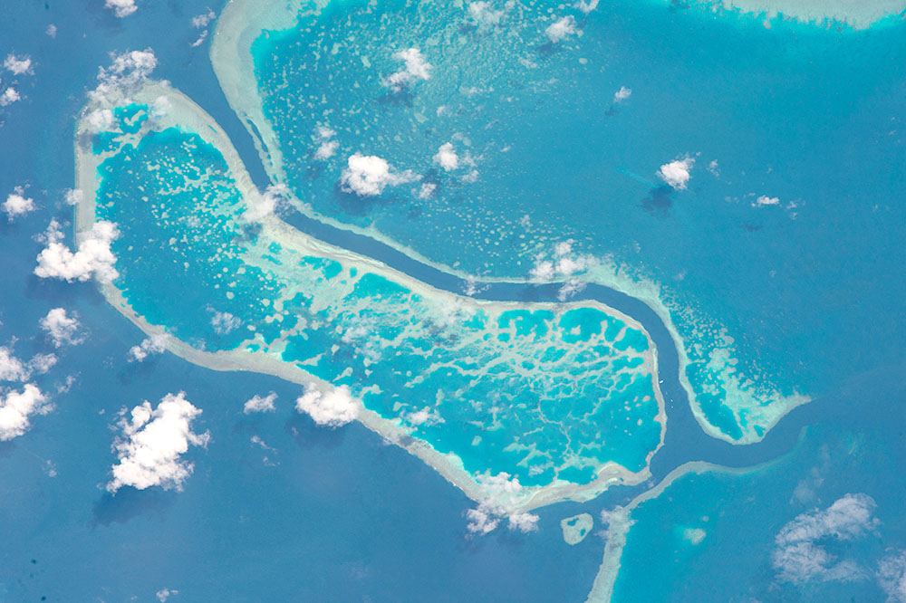
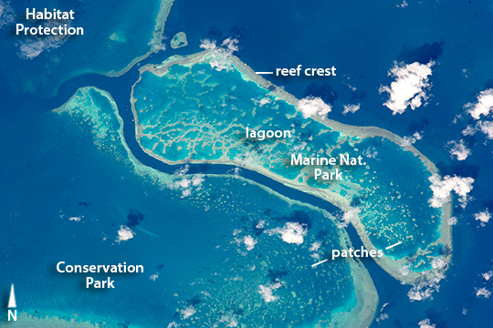
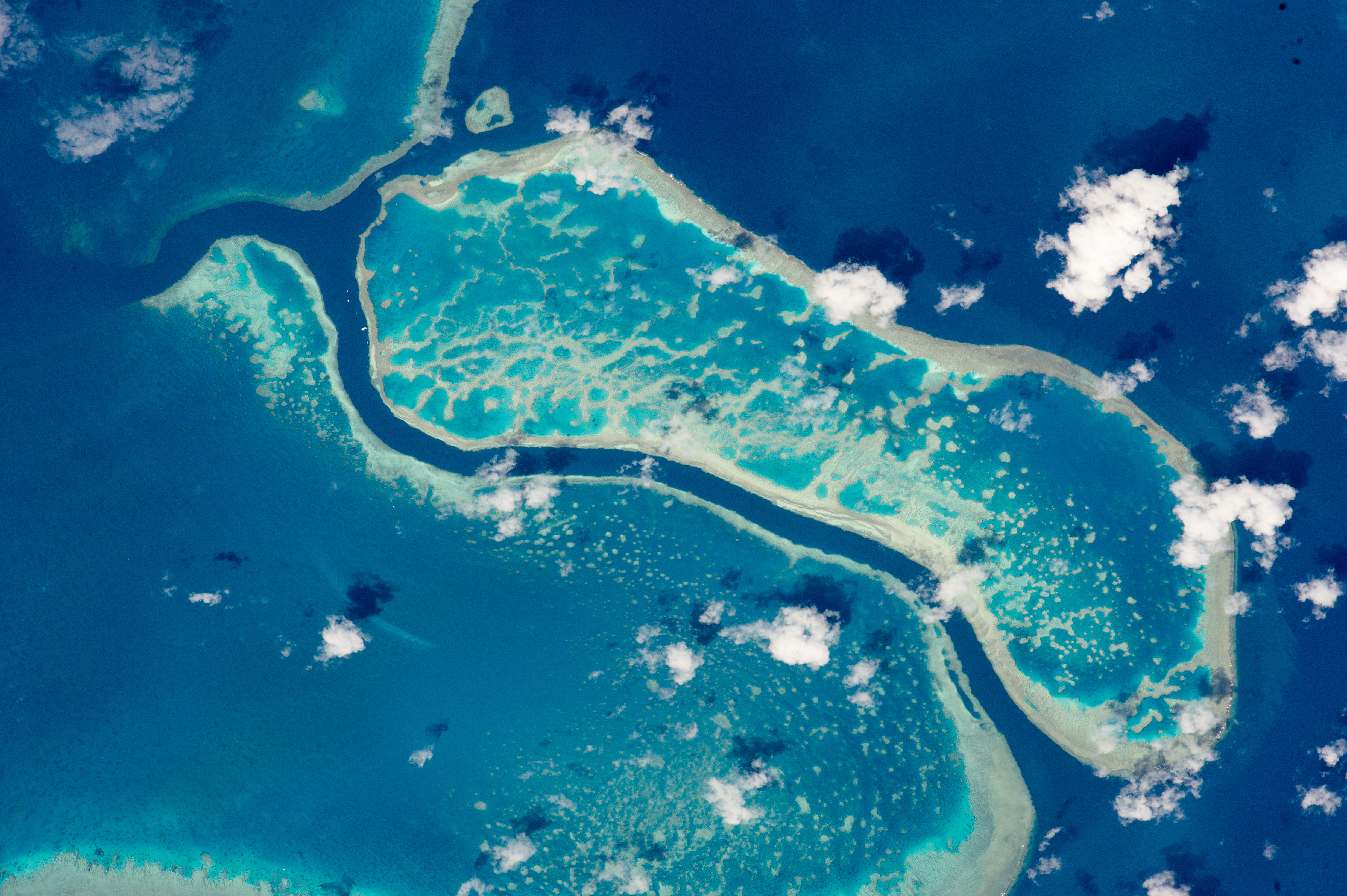
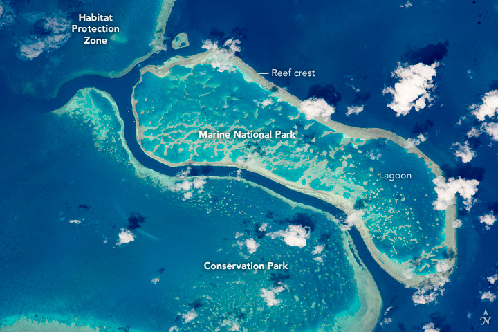
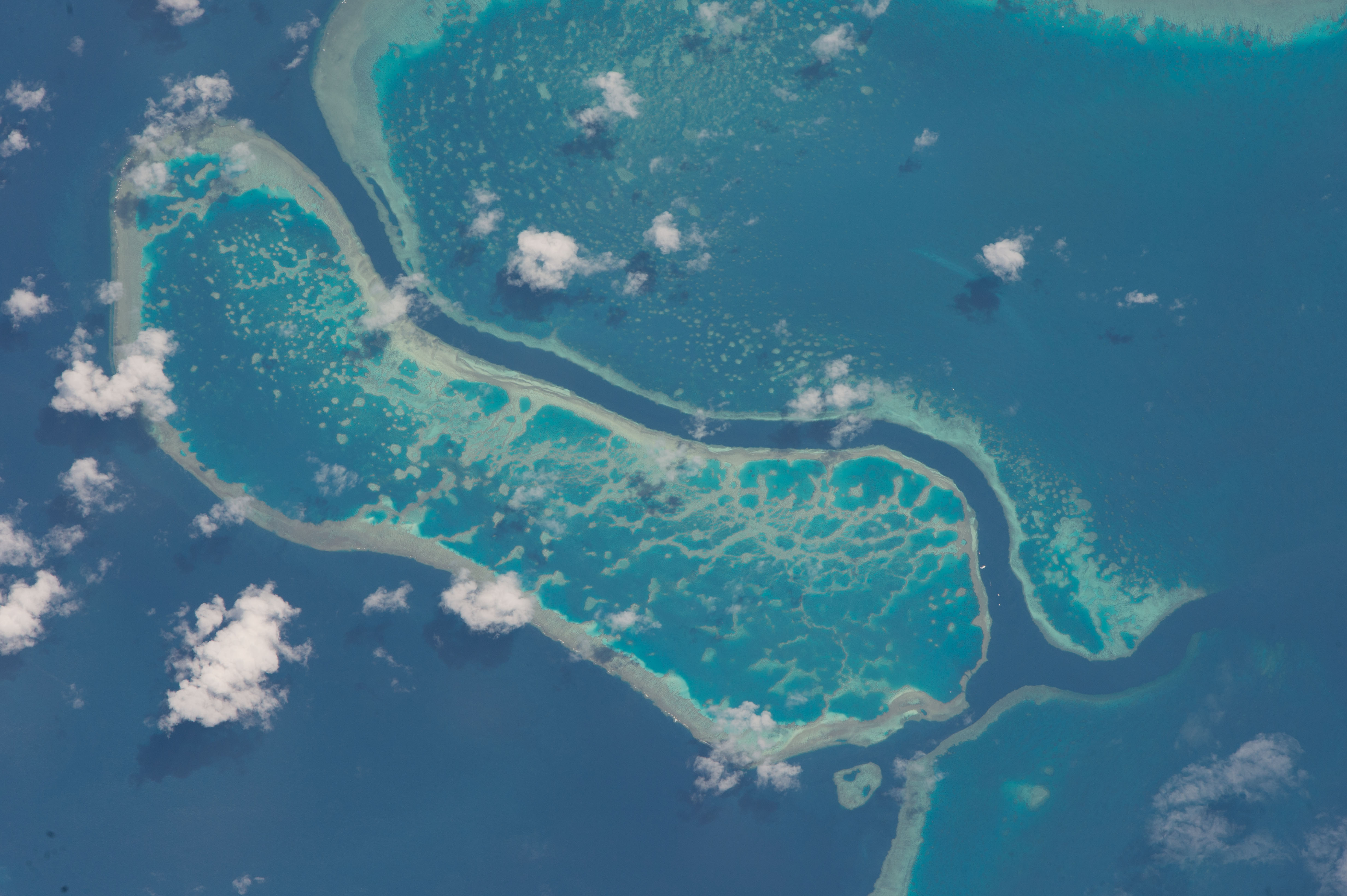
Image Caption: Great Barrier Reef, Queensland, Australia
These three reefs in Australia's Great Barrier Reef (GBR) were photographed by an astronaut aboard the International Space Station. Taken with a powerful lens, this image shows 15 km (10 miles) of the 2300 km (1700 miles) of the GBR. Reefs are easy to find from space, because iridescent blues of shallow water in lagoons contrast at a sharp line with the dark blue tone of deep water. The GBR is the largest reef system on Earth with more than 3000 separate reefs and coral cays. It is one of the most complex natural ecosystems, with 600 types of corals, and thousands of species of animals, from tiny plankton to whales.
Corals look like plants but are in fact colonies of very small animals known as coral polyps--closely related to jellyfish. The color differences in the image relate to different habitats for coral growth within the reef, habitats strongly related to two sources of energy and nutrient. Agitated water, as in the surface zone where waves break against the reef, provides more plankton nutrient to the corals than still water. The best developed reef crests face the open ocean (right side of the image) for this reason--especially reefs like these that lie 75 km (45 miles) from the Queensland coastline, far from land sources of nutrient. The dark narrow channels between the lagoons also allow deeper, nutrient-rich water to reach the reef-crest corals. But waves are also destructive, so that only robust types of coral live within the breaker zone. The other source of energy is the sun which is needed by symbiotic, single-cell organisms that provide most of the nutrient for coral growth. The dark blues in the image are zones where too little light penetrates. Tropical corals disappear where the light fades away around 60 meters (200 feet) below the sea surface. By contrast, shallow water within the lagoons (especially at image center) has the strongest light supply and displays numerous patches of coral. Although lagoons are protected from the full force of waves they lack the plankton supply from constant wave agitation. This limits the amount of living coral within the lagoon, as seen in the empty zones. But the lagoons have so many micro-habitats that they boast the greatest number of species in the reef ecosystem, with mollusks, worms and crustaceans often dominating the visible fauna.
The GBR is now protected in a Marine Park. The three reefs captured here--part of the Planning Area for the Whitsunday group of islands 900 km (560 miles) north of Brisbane in Queensland--have different types of protected status. The reef at image top left is a Habitat Protection zone (controlling potentially damaging activities such as trawling), the reef at image lower left is a Conservation Park (limited fishing), and the reef at the center of the image as a Marine National Park (no fishing or collecting.)
