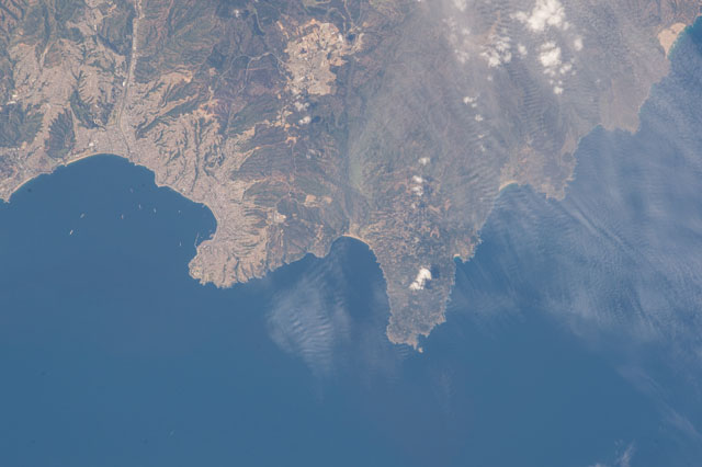
ISS045-E-24760
| NASA Photo ID | ISS045-E-24760 |
| Focal Length | 400mm |
| Date taken | 2015.09.22 |
| Time taken | 15:51:59 GMT |

Spacecraft nadir point: 33.2° S, 70.8° W
Photo center point: 33.1° S, 71.7° W
Photo center point by machine learning:
Photo center point: 33.1° S, 71.7° W
Photo center point by machine learning:
Nadir to Photo Center: West
Spacecraft Altitude: 220 nautical miles (407km)
Country or Geographic Name: | CHILE |
Features: | PACIFIC O., PT. CURAUMILLA, VALPARAISO, LAGUNA VERDE, CITIES, FOR., HILLS |
| Features Found Using Machine Learning: | |
Cloud Cover Percentage: | 50 (26-50)% |
Sun Elevation Angle: | 55° |
Sun Azimuth: | 19° |
Camera: | Nikon D4 Electronic Still Camera |
Focal Length: | 400mm |
Camera Tilt: | 14 degrees |
Format: | 4928E: 4928 x 3280 pixel CMOS sensor, 36.0mm x 23.9mm, total pixels: 16.6 million, Nikon FX format |
Film Exposure: | |
| Additional Information | |
| Width | Height | Annotated | Cropped | Purpose | Links |
|---|---|---|---|---|---|
| 4928 pixels | 3280 pixels | No | No | Download Image | |
| 640 pixels | 426 pixels | No | No | Download Image |
Download Packaged File
Download a Google Earth KML for this Image
View photo footprint information
Download a GeoTIFF for this photo
Georeferenced by human interaction - exported 2016-08-17-012528-UTCGeoreferenced by human interaction - exported 2016-08-24-022022-UTC
Georeferenced by human interaction - exported 2018-01-16-173338-UTC
An explanation of the georeference file(s) above
Image Caption: none
