ISS044-E-885
| NASA Photo ID | ISS044-E-885 |
| Focal Length | 1150mm |
| Date taken | 2015.06.11 |
| Time taken | 05:20:49 GMT |
1000 x 666 pixels 540 x 360 pixels 2464 x 1640 pixels 720 x 480 pixels 4928 x 3280 pixels 640 x 426 pixels
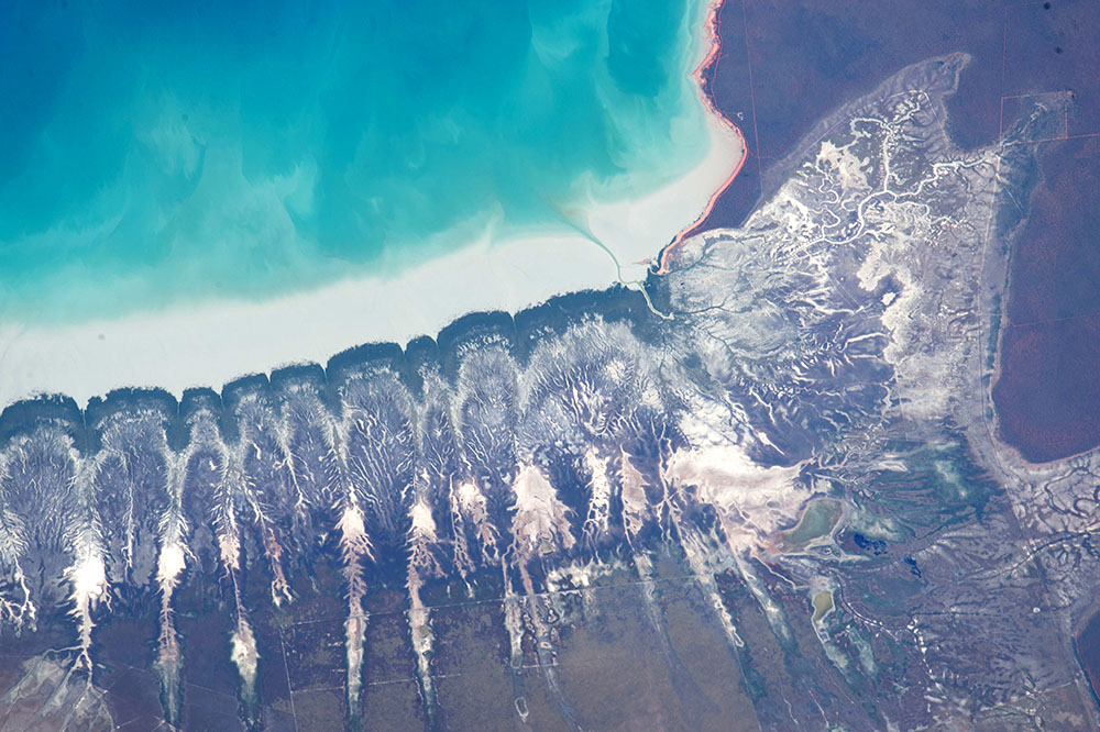


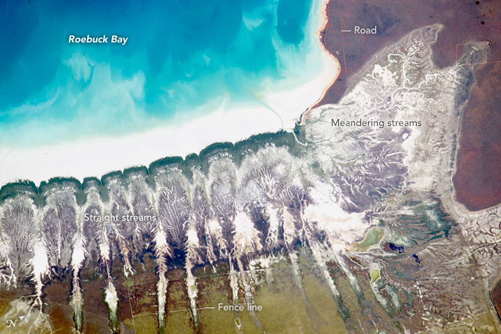
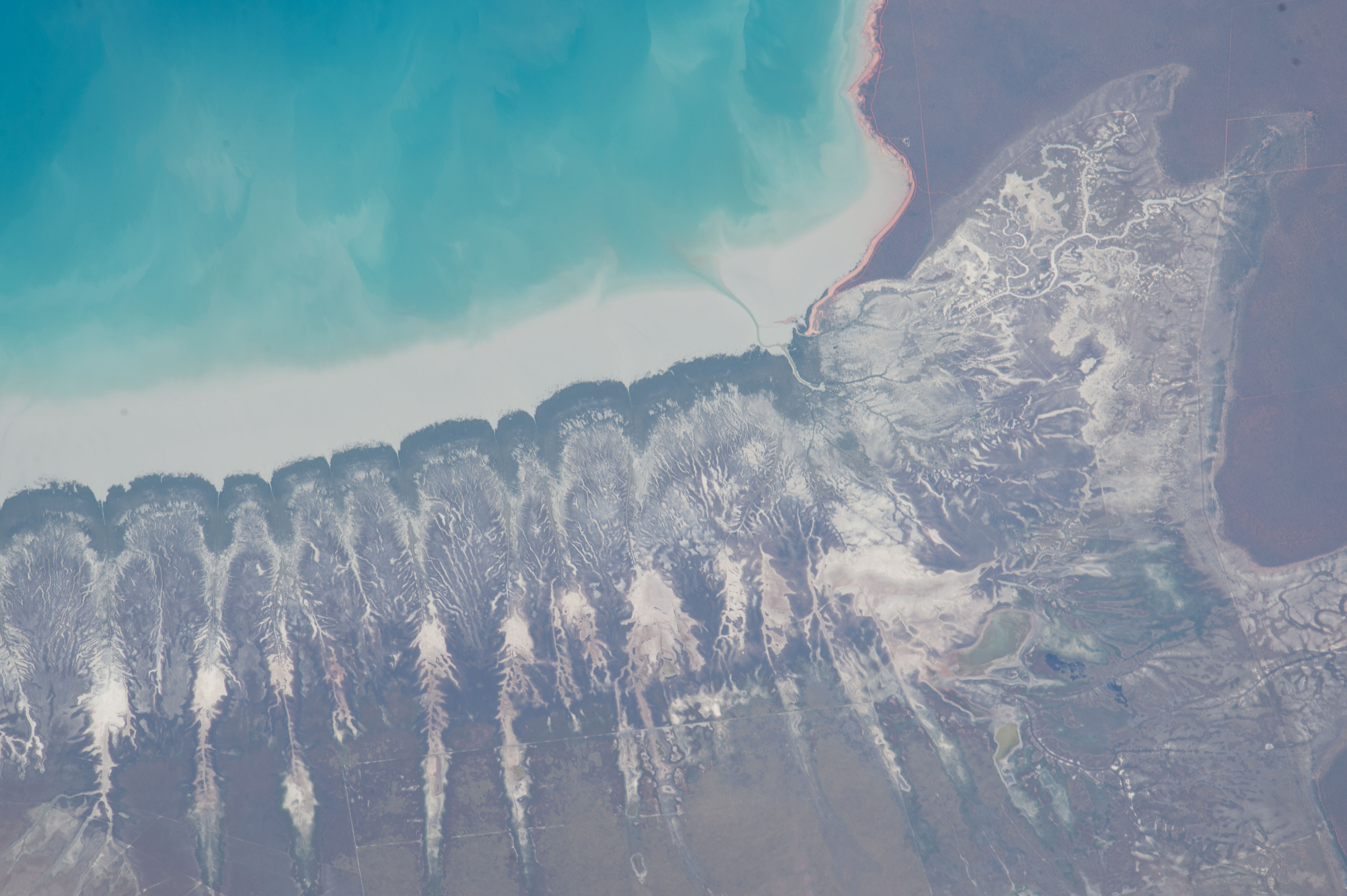


Photo center point: 18.0° S, 122.4° E
Photo center point by machine learning:
Country or Geographic Name: | AUSTRALIA-WA |
Features: | ROEBUCK B., PARALLEL COASTAL STREAMS |
| Features Found Using Machine Learning: | |
Cloud Cover Percentage: | 10 (1-10)% |
Sun Elevation Angle: | 44° |
Sun Azimuth: | 335° |
Camera: | Nikon D4 Electronic Still Camera |
Focal Length: | 1150mm |
Camera Tilt: | 44 degrees |
Format: | 4928E: 4928 x 3280 pixel CMOS sensor, 36.0mm x 23.9mm, total pixels: 16.6 million, Nikon FX format |
Film Exposure: | |
| Additional Information | |
| Width | Height | Annotated | Cropped | Purpose | Links |
|---|---|---|---|---|---|
| 1000 pixels | 666 pixels | No | No | Earth From Space collection | Download Image |
| 540 pixels | 360 pixels | Yes | No | Earth From Space collection | Download Image |
| 2464 pixels | 1640 pixels | No | No | NASA's Earth Observatory web site | Download Image |
| 720 pixels | 480 pixels | Yes | No | NASA's Earth Observatory web site | Download Image |
| 4928 pixels | 3280 pixels | No | No | Download Image | |
| 640 pixels | 426 pixels | No | No | Download Image |
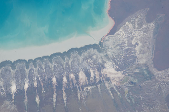
This detailed image taken by an astronaut aboard the International Space Station shows strikingly regular shoreline patterns at Roebuck Bay on the coast of the desert country of Western Australia. The indents along the shoreline (image center and left) are points where small straight streams reach the bay. Even smaller tributaries give a feathered appearance to this shoreline. By contrast, more typical meandering channel patterns of coastal wetlands appear top right. Almost no human-built patterns can be seen even though the town of Broome lies just outside the image top right. Fence lines cross the straight streams in the bottom third of the image.
Looking for an explanation of the regularity of the stream pattern, geologists searched more widely in the surrounding area. They found several inland dunefields that show the same straight pattern of parallel "linear dunes." Interestingly, the dunes are spaced generally the same distance apart as between the straight streams. Dunes and the straight streams are also all aligned with the dominant easterly wind. It seems likely that dunes produced by the same winds once occupied the bay shore, and even though they are not visible today, may have controlled the spacing and linearity on the straight streams. The phenomenon of streams forming in the parallel lows between the linear dunes is well known in desert landscapes.
This detailed image of Roebuck Bay shows fifteen km of coastline. The bay can be located on the lower left corner of the panoramic astronaut view ISS040-E-89959.
