ISS043-E-83229

| NASA Photo ID | ISS043-E-83229 |
| Focal Length | 290mm |
| Date taken | 2015.04.02 |
| Time taken | 13:37:43 GMT |
1000 x 666 pixels 540 x 360 pixels 2464 x 1640 pixels 720 x 480 pixels 4928 x 3280 pixels 640 x 426 pixels
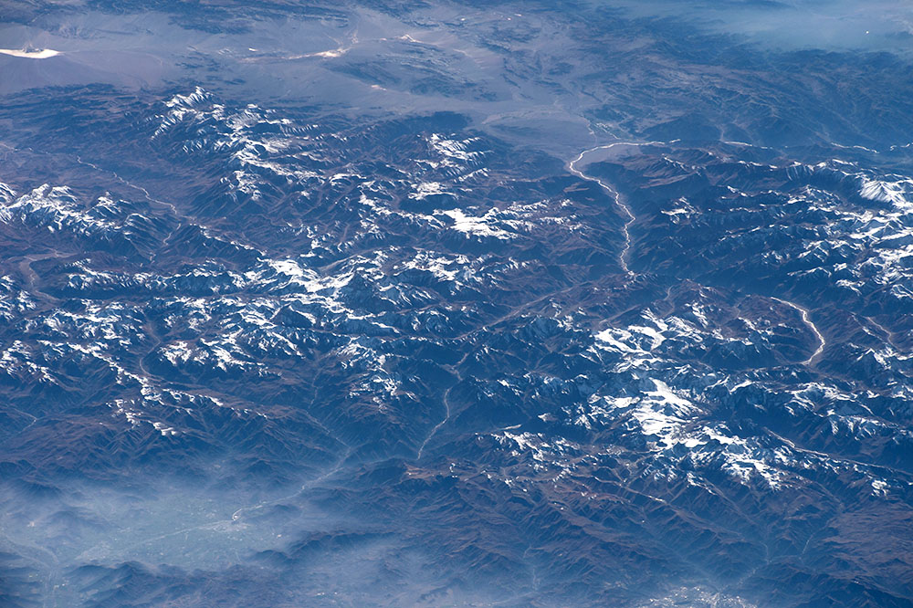
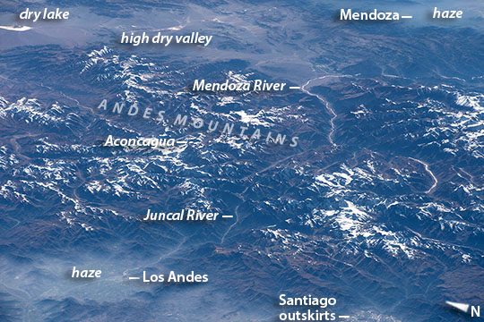
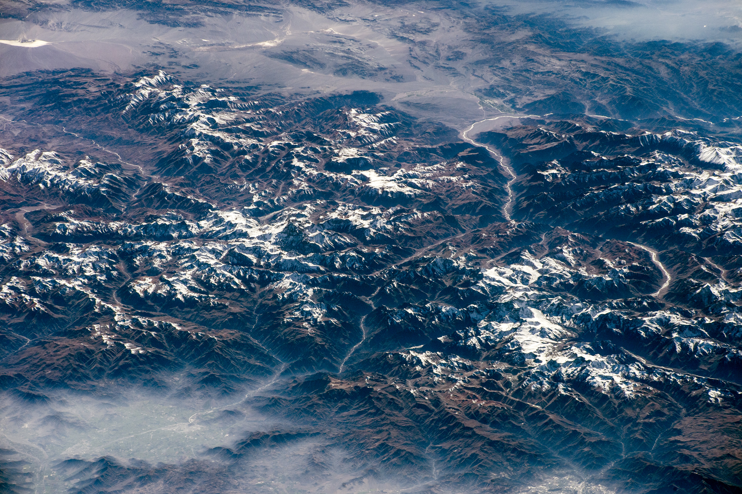
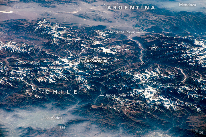
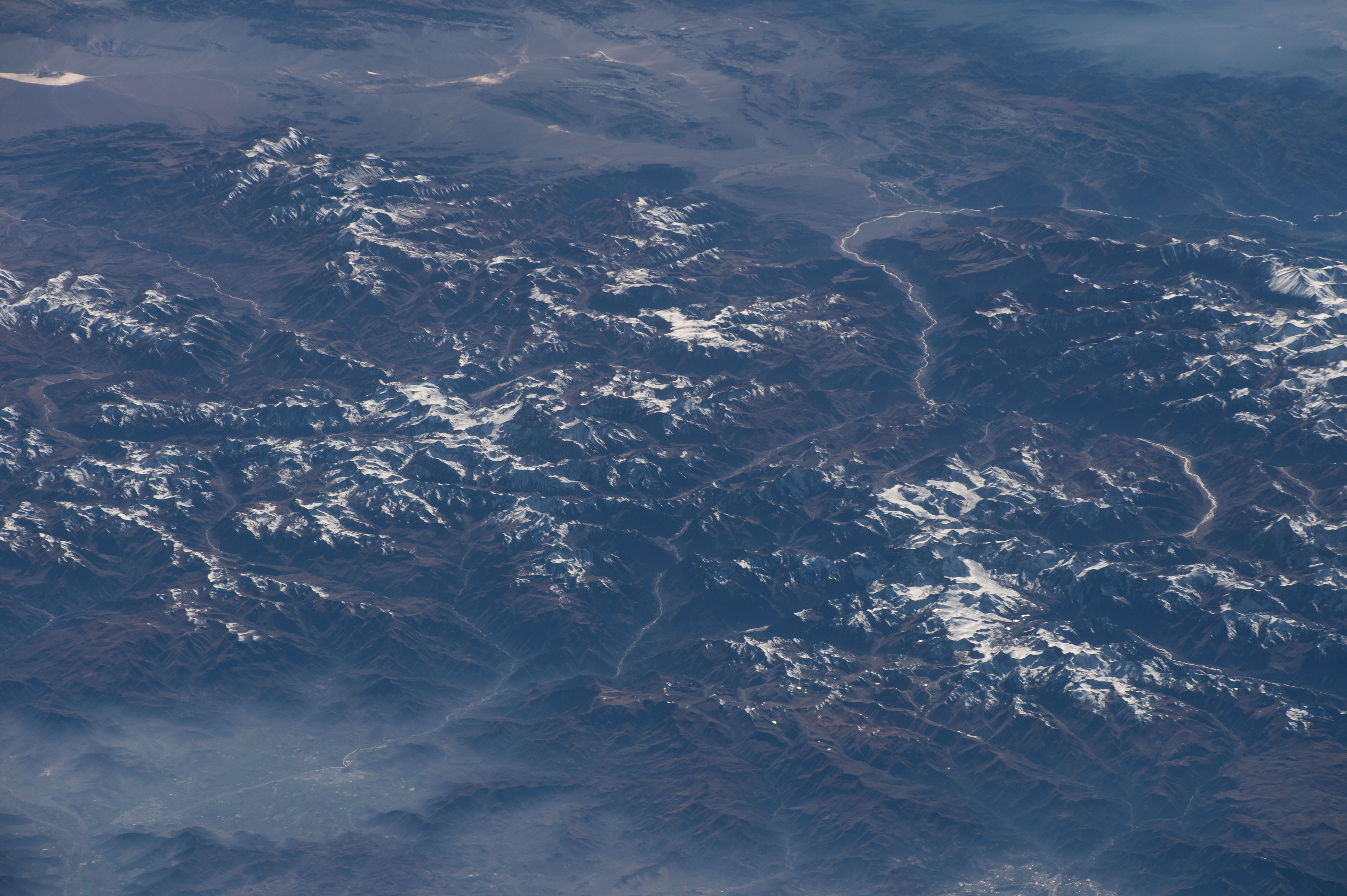


Photo center point: 32.8° S, 70.0° W
Photo center point by machine learning:
Country or Geographic Name: | ARGENTINA |
Features: | ANDES MTS., HAZE, MENDOZA R., SANTIAGO |
| Features Found Using Machine Learning: | |
Cloud Cover Percentage: | 10 (1-10)% |
Sun Elevation Angle: | 25° |
Sun Azimuth: | 62° |
Camera: | Nikon D4 Electronic Still Camera |
Focal Length: | 290mm |
Camera Tilt: | High Oblique |
Format: | 4928E: 4928 x 3280 pixel CMOS sensor, 36.0mm x 23.9mm, total pixels: 16.6 million, Nikon FX format |
Film Exposure: | |
| Additional Information | |
| Width | Height | Annotated | Cropped | Purpose | Links |
|---|---|---|---|---|---|
| 1000 pixels | 666 pixels | No | No | Earth From Space collection | Download Image |
| 540 pixels | 360 pixels | Yes | No | Earth From Space collection | Download Image |
| 2464 pixels | 1640 pixels | No | No | NASA's Earth Observatory web site | Download Image |
| 720 pixels | 480 pixels | Yes | No | NASA's Earth Observatory web site | Download Image |
| 4928 pixels | 3280 pixels | No | No | Download Image | |
| 640 pixels | 426 pixels | No | No | Download Image |
From 700 km distance over the Pacific Ocean, an astronaut aboard the International Space Station took this oblique image of a part of the Andes Mountains. The mountain ranges cross the entire image and form the border between in Chile in the foreground and Argentina's wine country (across the top of the image). This view is unusual because it reveals precisely the canyons and valleys followed by the Pan America Highway: the spacecraft and sun were in just the right positions for the sun's reflection to reveal the thin bright rivers in the deep valleys followed by the highway. The pass over the Andes is the main route between Chile's capital Santiago, whose outskirts appear at image lower right, and Mendoza, the heart of Argentina's winemaking industry. Mendoza's basin lies under haze at image top right corner.
The highway route over the Andes starts just north of Chile's capital city Santiago at the small town of Los Andes (at image lower left), snaking its way up the forested Juncal River valley where it passes close to Aconcagua, the highest mountain peak in the Western Hemisphere (6959 m, 22,830 feet)(at image left center). Near Aconcagua the highway crosses the international boundary into the Mendoza River valley where it passes through a high, treeless desert valley (with a dry lake at image top left corner). Then the highway bends southeast and descends to the Mendoza basin, marked here by a blanket of haze. Haze, a variable mix of smoke, dust and fog, is a typical winter phenomenon on windless days, as seen also in the basins in Chile where Santiago and Los Andes are located.
The Pan-American Highway is an almost continuous road, 30,000 kilometers (19,000 mi) long, that joins seventeen countries in the Americas, from southernmost South America up through North America to the Arctic Ocean.
Despite frequent haze, the Santiago region of Chile is a favorite target for photographers in space (ISS040-E-10803, ISS022-E-75457).
