ISS043-E-2274
| NASA Photo ID | ISS043-E-2274 |
| Focal Length | 50mm |
| Date taken | 2015.03.14 |
| Time taken | 17:25:59 GMT |


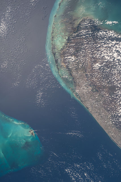
Spacecraft nadir point: 25.6° N, 79.8° W
Photo center point: 25.5° N, 80.0° W
Photo center point by machine learning:
Photo center point: 25.5° N, 80.0° W
Photo center point by machine learning:
Nadir to Photo Center:
Spacecraft Altitude: 213 nautical miles (394km)
Country or Geographic Name: | USA-FLORIDA |
Features: | PUBLIC INPUTS (from public image detectives, not NASA): MIAMI FL,MAIMI,BISCAYNE BAY,KEY LARGO,MIAMI INTERNATIONAL AIRPORT (KMIA),BIMINI ISLANDS,ALICE TOWN ISLAND,FLORIDA KEYS,EVERGLADES |
| Features Found Using Machine Learning: | |
Cloud Cover Percentage: | 25 (11-25)% |
Sun Elevation Angle: | 62° |
Sun Azimuth: | 179° |
Camera: | Nikon D4 Electronic Still Camera |
Focal Length: | 50mm |
Camera Tilt: | 04 degrees |
Format: | 4928E: 4928 x 3280 pixel CMOS sensor, 36.0mm x 23.9mm, total pixels: 16.6 million, Nikon FX format |
Film Exposure: | |
| Additional Information | |
This photo is one of the photos used to create this time-lapse video:
| Width | Height | Annotated | Cropped | Purpose | Links |
|---|---|---|---|---|---|
| 3280 pixels | 4928 pixels | No | No | Download Image | |
| 426 pixels | 640 pixels | No | No | Download Image |
Download Packaged File
Download a Google Earth KML for this Image
View photo footprint information
Download a GeoTIFF for this photo
Image Caption: none
