ISS042-E-16183
| NASA Photo ID | ISS042-E-16183 |
| Focal Length | 17mm |
| Date taken | 2014.11.26 |
| Time taken | 06:31:47 GMT |
Resolutions offered for this image:
1000 x 1022 pixels 540 x 552 pixels 3280 x 3280 pixels 720 x 720 pixels 3280 x 4928 pixels 426 x 640 pixels
1000 x 1022 pixels 540 x 552 pixels 3280 x 3280 pixels 720 x 720 pixels 3280 x 4928 pixels 426 x 640 pixels

Spacecraft nadir point: 25.7° N, 10.7° E
Photo center point: 24.5° N, 14.5° E
Photo center point by machine learning:
Photo center point: 24.5° N, 14.5° E
Photo center point by machine learning:
Nadir to Photo Center: East
Spacecraft Altitude: 220 nautical miles (407km)
Country or Geographic Name: | LIBYA |
Features: | MARZUQ SAND SEA, TIBESTI MTS. |
| Features Found Using Machine Learning: | PAN- |
Cloud Cover Percentage: | 10 (1-10)% |
Sun Elevation Angle: | 9° |
Sun Azimuth: | 119° |
Camera: | Nikon D4 Electronic Still Camera |
Focal Length: | 17mm |
Camera Tilt: | 47 degrees |
Format: | 4928E: 4928 x 3280 pixel CMOS sensor, 36.0mm x 23.9mm, total pixels: 16.6 million, Nikon FX format |
Film Exposure: | |
| Additional Information | |
| Width | Height | Annotated | Cropped | Purpose | Links |
|---|---|---|---|---|---|
| 1000 pixels | 1022 pixels | No | Yes | Earth From Space collection | Download Image |
| 540 pixels | 552 pixels | Yes | Yes | Earth From Space collection | Download Image |
| 3280 pixels | 3280 pixels | No | No | NASA's Earth Observatory web site | Download Image |
| 720 pixels | 720 pixels | Yes | Yes | NASA's Earth Observatory web site | Download Image |
| 3280 pixels | 4928 pixels | No | No | Download Image | |
| 426 pixels | 640 pixels | No | No | Download Image |
Download Packaged File
Download a Google Earth KML for this Image
View photo footprint information
Download a GeoTIFF for this photo
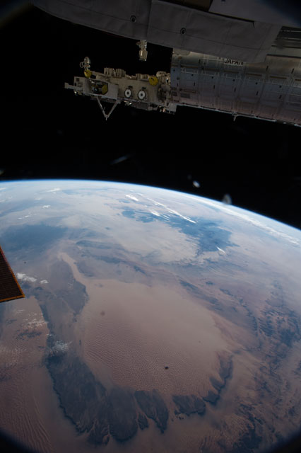
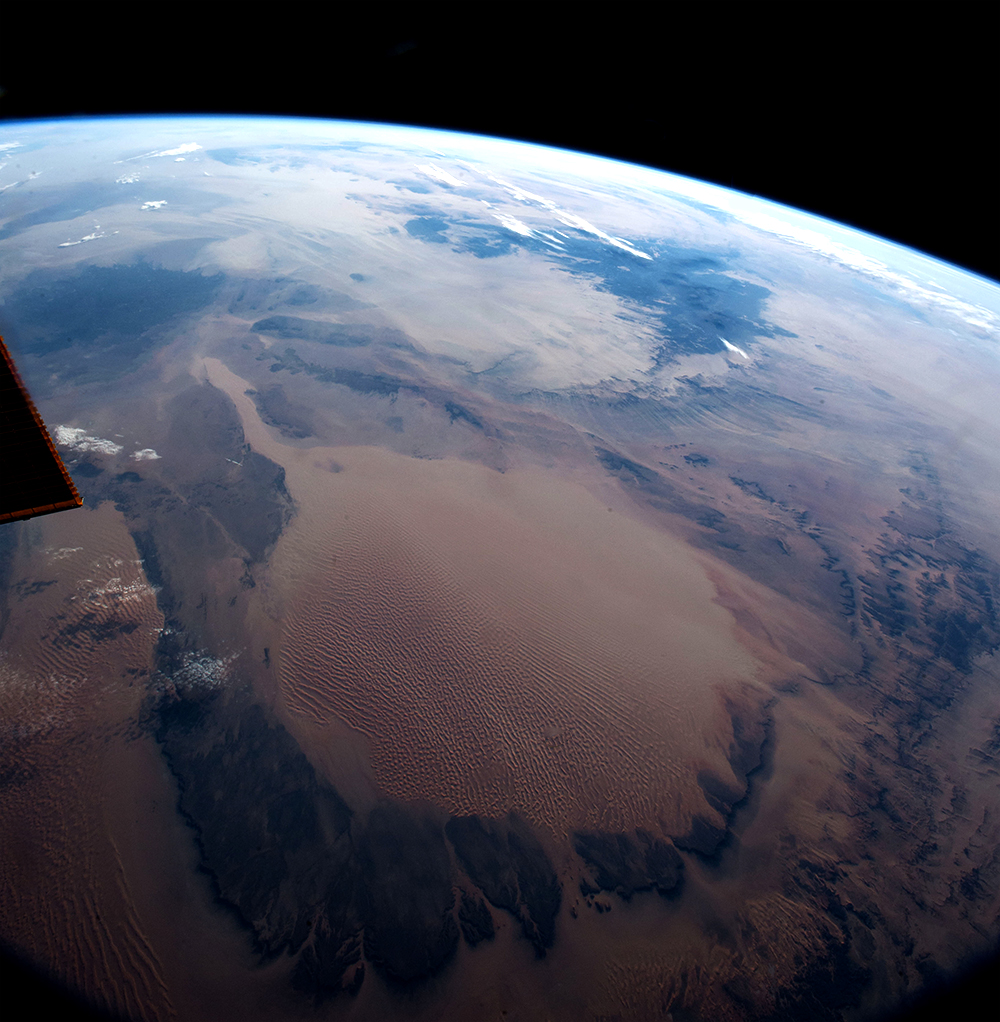
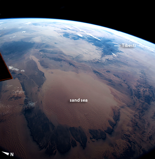
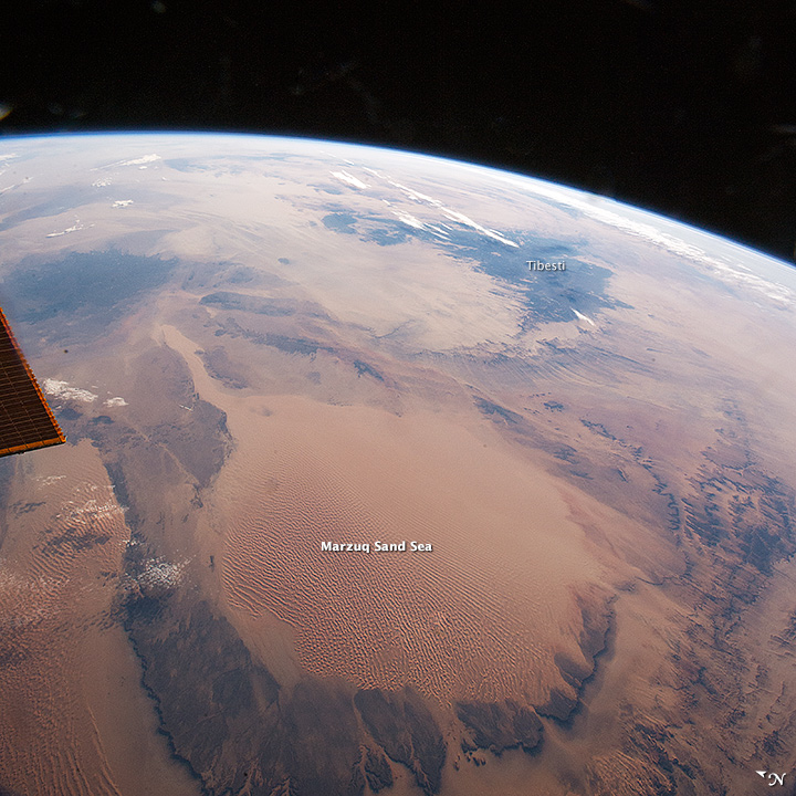
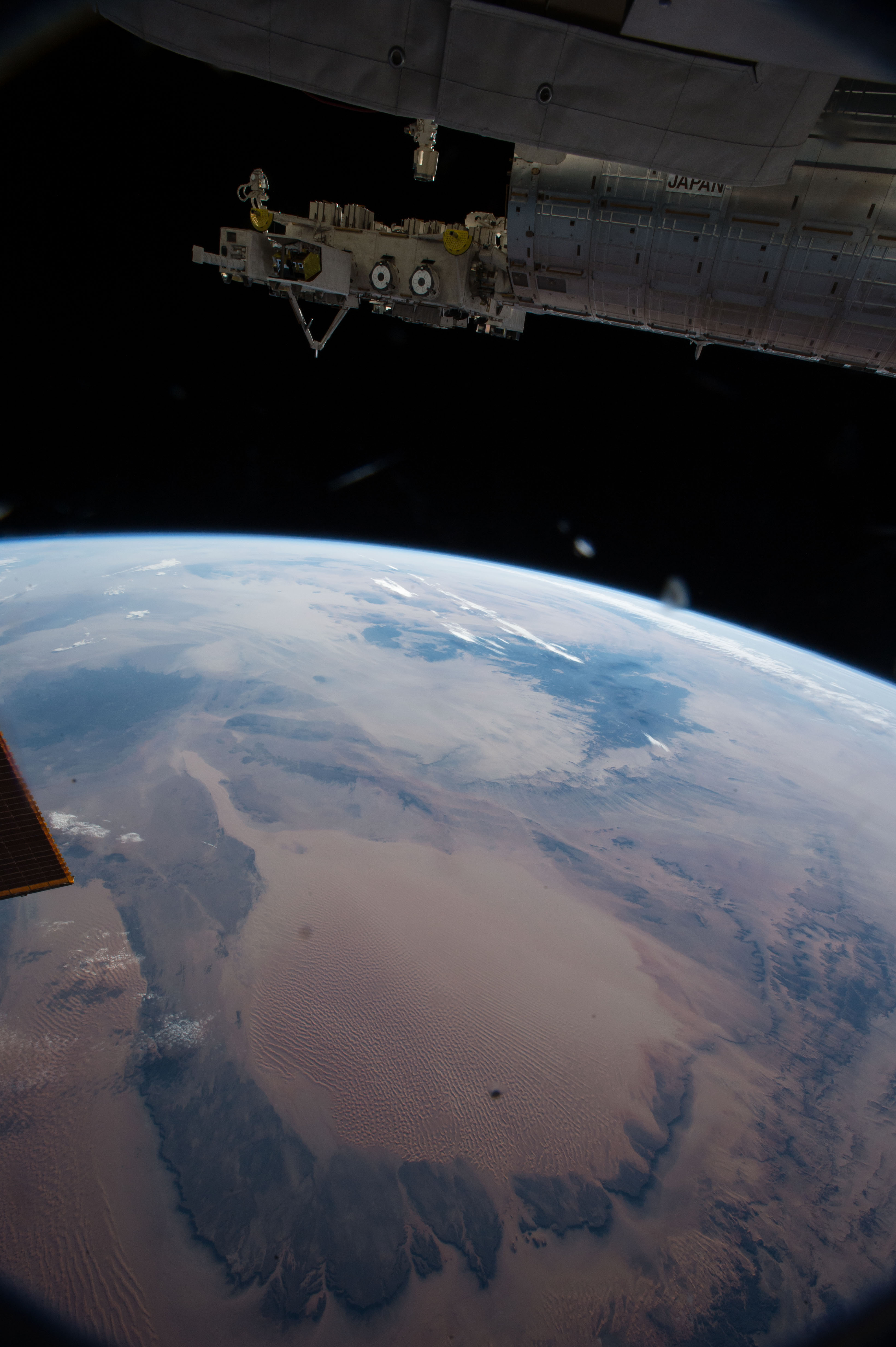
Image Caption: Marzuq Sand Sea, Libya
This picture of the central Sahara Desert was taken from the International Space Station shortly after sunrise. Tan colors of the vast, circular Marzuq Sand Sea in the foreground (300 km across, or 190 miles) contrast with the black lavas of the Tibesti Mountains near the horizon. The Sand Sea is one of the most recognizable features for orbiting astronauts, partly because they see it often under the cloudless Saharan skies.
Taken with a 17 mm lens, this view replicates closely what the human eye sees--unlike the detailed images commonly taken by Space Station crews for scientists. This lens gives a strong three dimensional sense--because the Earth curves away visibly toward the horizon, and the few clouds cast shadows toward the camera. The lens even captures the effect of different sun elevation in one view. The eastern Sahara on the horizon is in full daylight but the Sand Sea in the foreground is darker where sun is just rising.
