ISS041-E-105523

| NASA Photo ID | ISS041-E-105523 |
| Focal Length | 800mm |
| Date taken | 2014.10.30 |
| Time taken | 15:29:24 GMT |
Resolutions offered for this image:
1000 x 666 pixels 540 x 360 pixels 4928 x 3280 pixels 720 x 480 pixels 4928 x 3280 pixels 640 x 426 pixels
1000 x 666 pixels 540 x 360 pixels 4928 x 3280 pixels 720 x 480 pixels 4928 x 3280 pixels 640 x 426 pixels


Spacecraft nadir point: 37.0° N, 86.8° W
Photo center point: 35.1° N, 90.0° W
Photo center point by machine learning:
Photo center point: 35.1° N, 90.0° W
Photo center point by machine learning:
Nadir to Photo Center: Southwest
Spacecraft Altitude: 220 nautical miles (407km)
Country or Geographic Name: | USA-TENNESSEE |
Features: | MEMPHIS, MISSISSIPPI R., AGR. |
| Features Found Using Machine Learning: | |
Cloud Cover Percentage: | 10 (1-10)% |
Sun Elevation Angle: | 32° |
Sun Azimuth: | 145° |
Camera: | Nikon D4 Electronic Still Camera |
Focal Length: | 800mm |
Camera Tilt: | 45 degrees |
Format: | 4928E: 4928 x 3280 pixel CMOS sensor, 36.0mm x 23.9mm, total pixels: 16.6 million, Nikon FX format |
Film Exposure: | |
| Additional Information | |
| Width | Height | Annotated | Cropped | Purpose | Links |
|---|---|---|---|---|---|
| 1000 pixels | 666 pixels | No | No | Earth From Space collection | Download Image |
| 540 pixels | 360 pixels | No | No | Earth From Space collection | Download Image |
| 4928 pixels | 3280 pixels | No | No | NASA's Earth Observatory web site | Download Image |
| 720 pixels | 480 pixels | Yes | No | NASA's Earth Observatory web site | Download Image |
| 4928 pixels | 3280 pixels | No | No | Download Image | |
| 640 pixels | 426 pixels | No | No | Download Image |
Download Packaged File
Download a Google Earth KML for this Image
View photo footprint information
Download a GeoTIFF for this photo
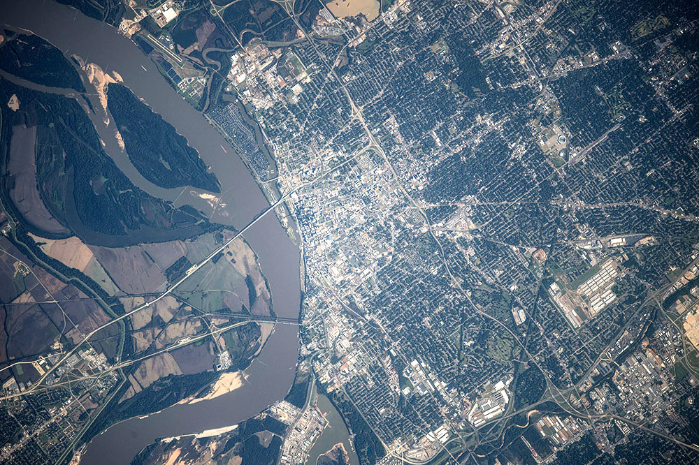
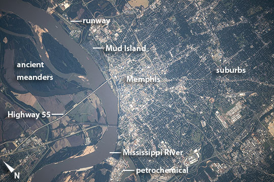
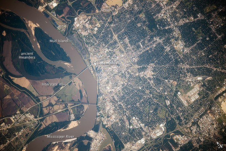
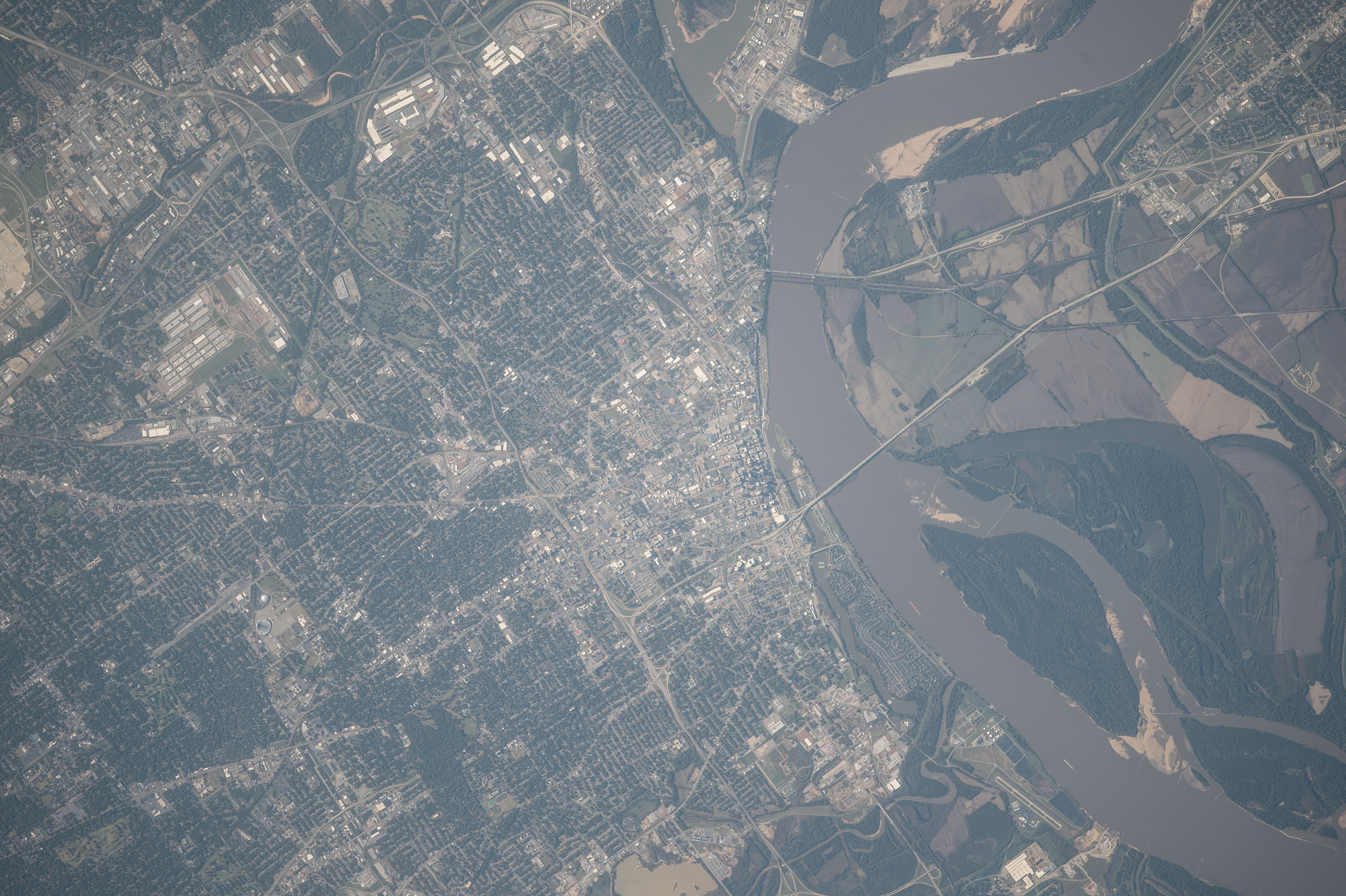
Image Caption: Memphis, Tennessee
Astronauts aboard the International Space Station took this detailed image of the city known as
Bluff City because of its location on high bluffs well above flood levels of the Mississippi River. The city center appears as a light gray tone facing a broad bend of the brown Mississippi River. Surrounding suburbs are green and distinctly darker. Cutting the grid of the city street pattern are major roads that radiate from the city center. The runway of a local airport appears top left next to the river.
Memphis lies where Tennessee adjoins Arkansas and Mississippi, and the population of greater Memphis (1.34 million) sprawls into these neighboring states, well beyond the area shown in this image. The city is a major regional transportation hub, with barge traffic on the river (barges can be seen in this image opposite Mud Island) and several Interstate highways passing through it. Bridges for two interstates cross the river, and their shadows even appear in this detailed view (for scale, the Interstate 55 bridge is 0.7 miles long). The low country opposite the city center is dominated by agricultural fields and the broad sweep of ancient meanders of the Mississippi River. Little Rock, Arkansas is a city on the opposite side of the Mississippi valley with a similar location on bluffs overlooking meander scars of the Arkansas River, a major tributary of the Mississippi River.
