ISS040-E-788

| NASA Photo ID | ISS040-E-788 |
| Focal Length | 80mm |
| Date taken | 2014.05.20 |
| Time taken | 11:11:18 GMT |
Resolutions offered for this image:
1000 x 665 pixels 540 x 359 pixels 4256 x 2832 pixels 720 x 480 pixels 4256 x 2832 pixels 640 x 426 pixels
1000 x 665 pixels 540 x 359 pixels 4256 x 2832 pixels 720 x 480 pixels 4256 x 2832 pixels 640 x 426 pixels

Spacecraft nadir point: 26.8° N, 12.3° W
Photo center point: 27.5° N, 13.0° W
Photo center point by machine learning:
Photo center point: 27.5° N, 13.0° W
Photo center point by machine learning:
Nadir to Photo Center: Northwest
Spacecraft Altitude: 223 nautical miles (413km)
Country or Geographic Name: | MOROCCO |
Features: | COASTLINE, WIND STREAKS, RAILROAD |
| Features Found Using Machine Learning: | |
Cloud Cover Percentage: | 10 (1-10)% |
Sun Elevation Angle: | 67° |
Sun Azimuth: | 102° |
Camera: | Nikon D3S Electronic Still Camera |
Focal Length: | 80mm |
Camera Tilt: | 15 degrees |
Format: | 4256E: 4256 x 2832 pixel CMOS sensor, 36.0mm x 23.9mm, total pixels: 12.87 million, Nikon FX format |
Film Exposure: | |
| Additional Information | |
| Width | Height | Annotated | Cropped | Purpose | Links |
|---|---|---|---|---|---|
| 1000 pixels | 665 pixels | No | No | Earth From Space collection | Download Image |
| 540 pixels | 359 pixels | Yes | No | Earth From Space collection | Download Image |
| 4256 pixels | 2832 pixels | No | No | Download Image | |
| 720 pixels | 480 pixels | Yes | No | NASA's Earth Observatory web site | Download Image |
| 4256 pixels | 2832 pixels | No | No | Download Image | |
| 640 pixels | 426 pixels | No | No | Download Image |
Download Packaged File
Download a Google Earth KML for this Image
View photo footprint information
Download a GeoTIFF for this photo
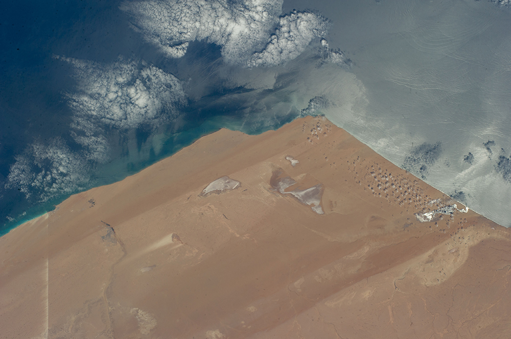
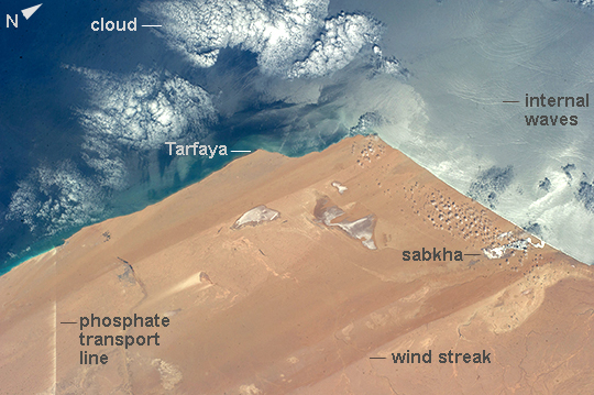
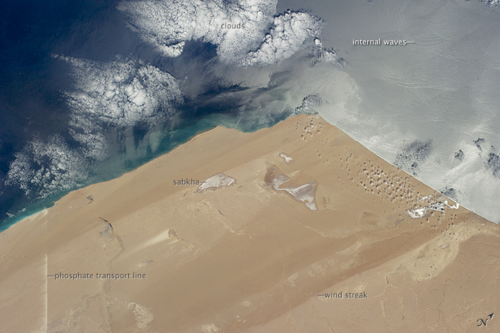
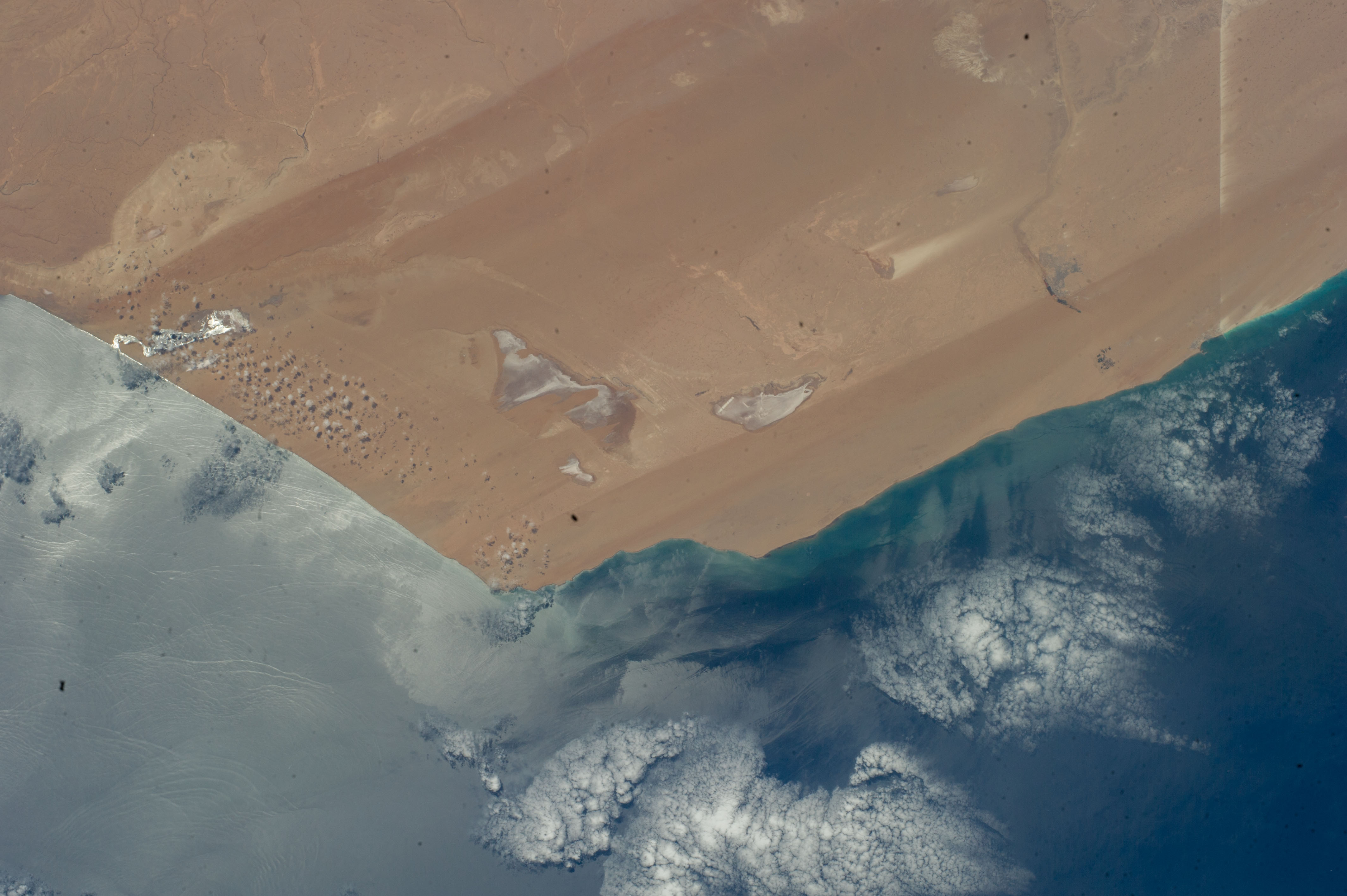
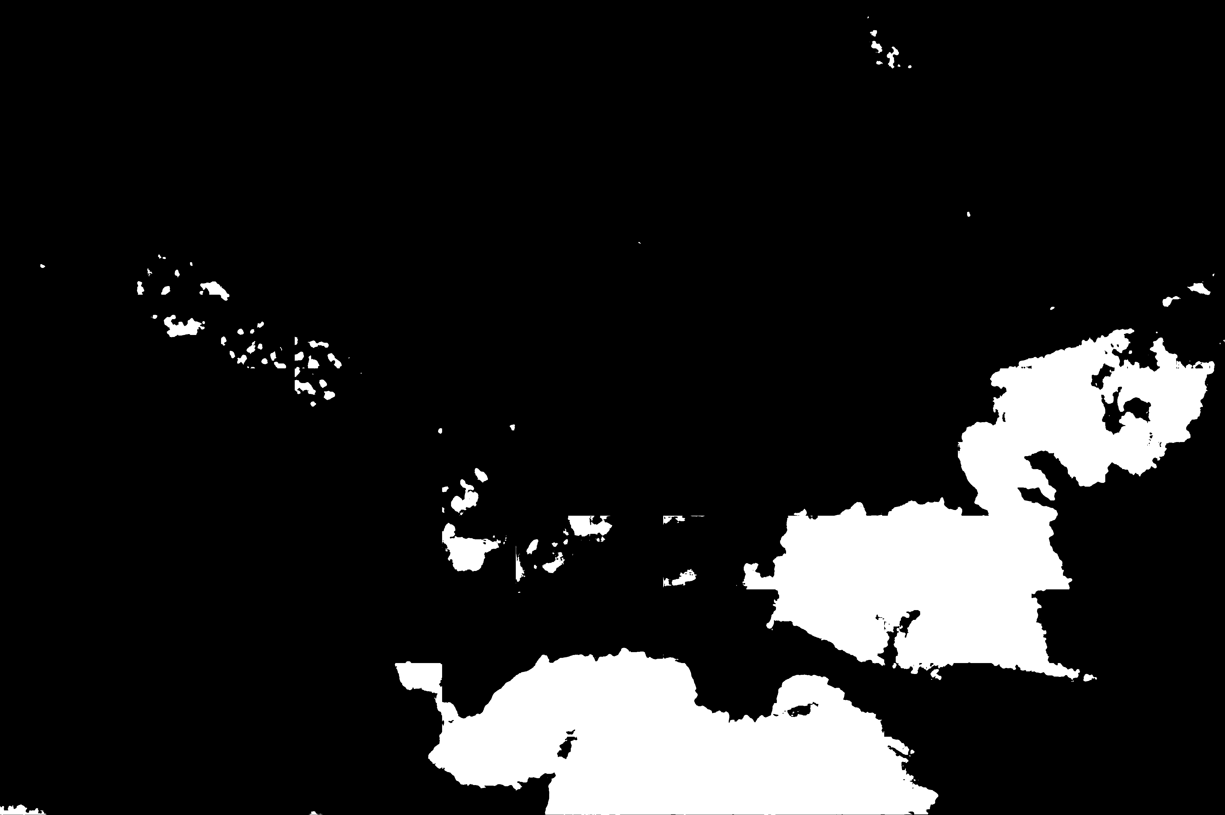
Image Caption: Desert coast--Morocco, Western Sahara
Recently tweeted from the International Space Station, this image of the extremely arid West African coast of the Atlantic Ocean looks otherworldly. The image shows 215 km (134 mi) of the Saharan coastline. The main patterns seen from orbit are the straight lines produced by strong northerly winds that blow parallel to the coast, producing wind streaks of sand and sand-free surfaces. The sun's rays are reflected off salty lagoons known as sabkhas near the coast. Sediment from wave erosion of the coastline makes a green-tinged margin to the land. Less prominent than the bright puffy clouds (image bottom) are subtle sunglint features known as "internal waves" that move in groups towards the coastline (image lower left).
The bright straight line at image upper right is a transport corridor of roads, railroads and conveyor belt systems that transport phosphates 100 km from inland mines to the coast. Strong northerly winds blow dust and phosphate into the desert, giving a jagged edge to this line on its south side. The features in this image--unfamiliar to many--are common in other west coast deserts such as the Namib Desert of Namibia and the Atacama Desert of Chile and Peru.
