ISS039-E-11773

| NASA Photo ID | ISS039-E-11773 |
| Focal Length | 80mm |
| Date taken | 2014.04.14 |
| Time taken | 06:45:30 GMT |
Resolutions offered for this image:
1000 x 617 pixels 540 x 329 pixels 4256 x 2832 pixels 720 x 480 pixels 4256 x 2832 pixels 640 x 426 pixels
1000 x 617 pixels 540 x 329 pixels 4256 x 2832 pixels 720 x 480 pixels 4256 x 2832 pixels 640 x 426 pixels


Spacecraft nadir point: 41.5° N, 156.7° E
Photo center point: 45.0° N, 146.5° E
Photo center point by machine learning:
Photo center point: 45.0° N, 146.5° E
Photo center point by machine learning:
Nadir to Photo Center: West
Spacecraft Altitude: 220 nautical miles (407km)
Country or Geographic Name: | RUSSIAN FEDERATION |
Features: | OKHOTSK SEA, KURIL ISLANDS, ICE, HAZE |
| Features Found Using Machine Learning: | PAN- |
Cloud Cover Percentage: | 10 (1-10)% |
Sun Elevation Angle: | 15° |
Sun Azimuth: | 269° |
Camera: | Nikon D3S Electronic Still Camera |
Focal Length: | 80mm |
Camera Tilt: | High Oblique |
Format: | 4256E: 4256 x 2832 pixel CMOS sensor, 36.0mm x 23.9mm, total pixels: 12.87 million, Nikon FX format |
Film Exposure: | |
| Additional Information | |
| Width | Height | Annotated | Cropped | Purpose | Links |
|---|---|---|---|---|---|
| 1000 pixels | 617 pixels | No | Yes | Earth From Space collection | Download Image |
| 540 pixels | 329 pixels | Yes | Yes | Earth From Space collection | Download Image |
| 4256 pixels | 2832 pixels | No | No | Download Image | |
| 720 pixels | 480 pixels | Yes | Yes | NASA's Earth Observatory web site | Download Image |
| 4256 pixels | 2832 pixels | No | No | Download Image | |
| 640 pixels | 426 pixels | No | No | Download Image |
Download Packaged File
Download a Google Earth KML for this Image
View photo footprint information
Download a GeoTIFF for this photo
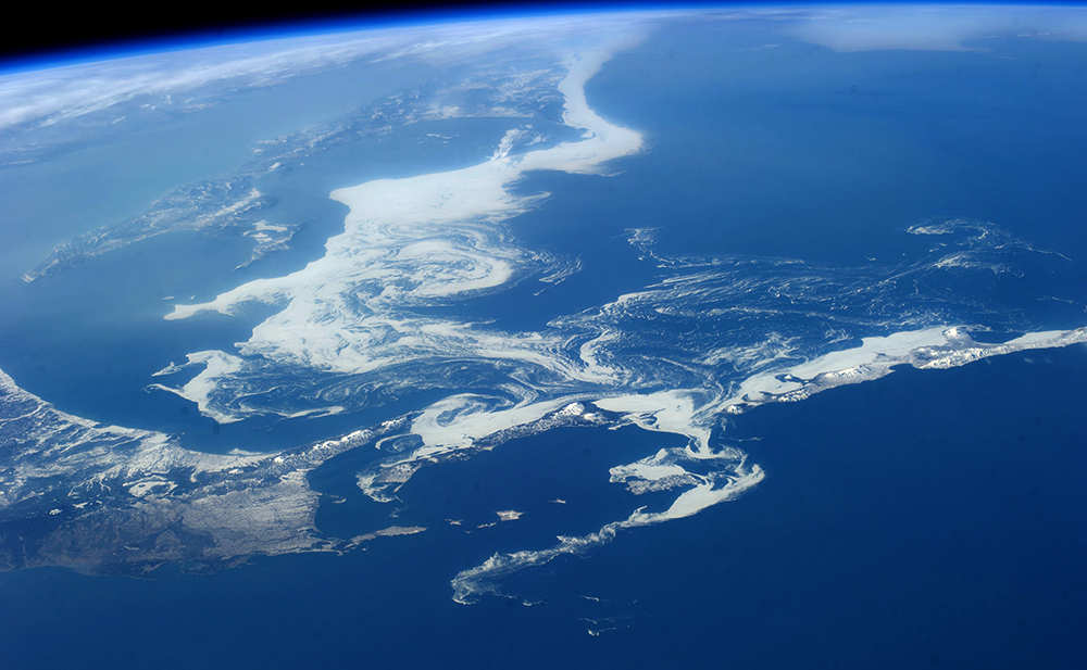
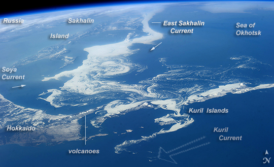
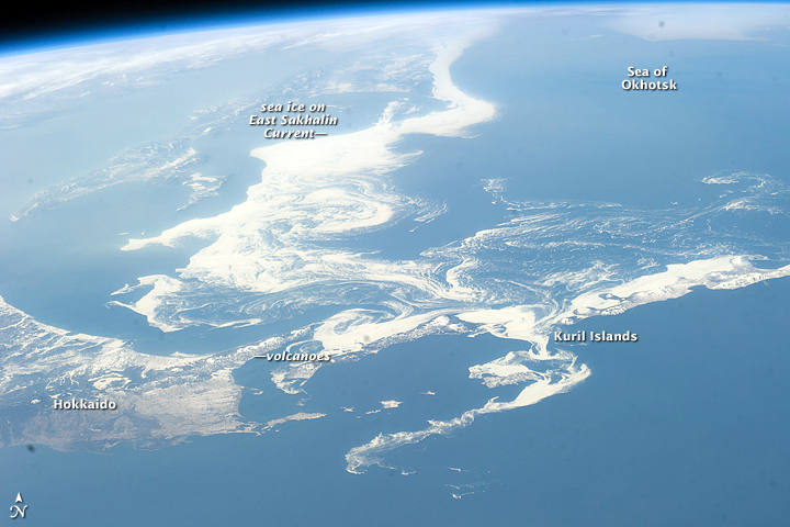
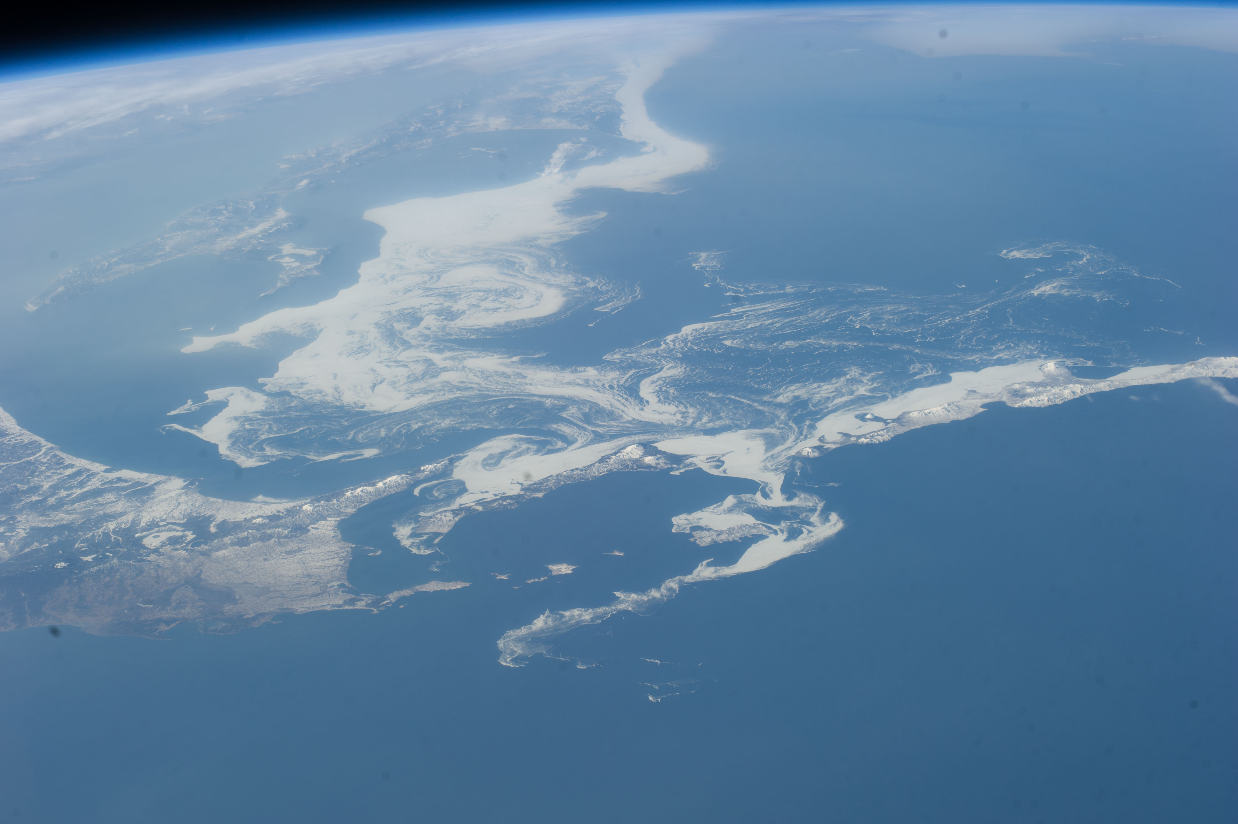
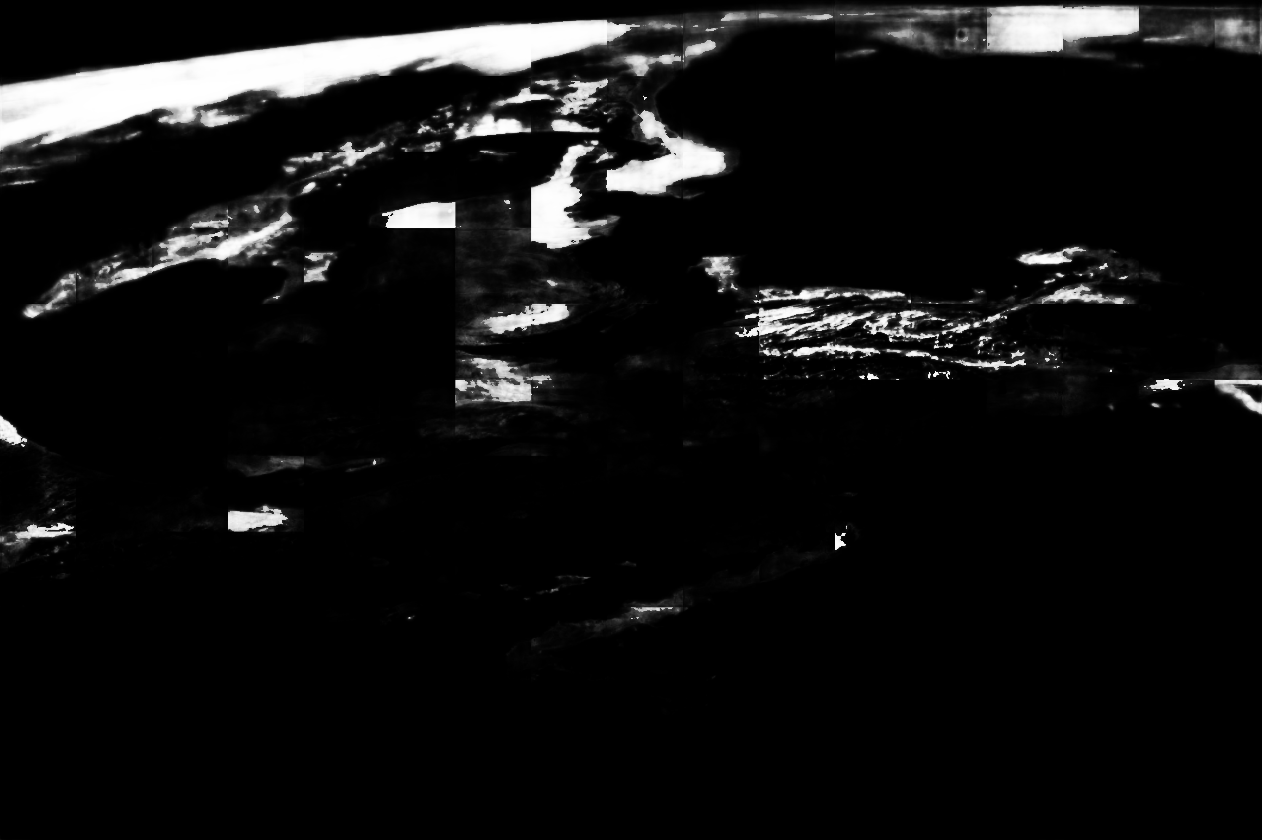
Image Caption: Sea of Okhotsk ice, Northern Japan
Patterns of sea ice in a spring panorama of the Sea of Okhotsk are featured in this image from the International Space Station. The image reveals dynamics of ocean currents that are otherwise difficult to visualize. Here we see nearly 1000 km of the East Sakhalin Current carrying winter ice south toward Japan's Hokkaido Island. The current is indicated by the narrow corridor of dense ice that hugs the coast of Sakhalin Island--slightly obscured under haze at image top left. Reaching the barrier of Hokkaido, the ice patterns show a series of eddies and swirls (image center). The current then turns and transports ice along the Kuril Island chain. Some ice spills through gaps where it is swept southwest by the Kuril Current (image lower right).
The East Sakhalin Current dies back in summer when the Soya Current (arrow far left) begins to enter the Sea of Okhotsk. This inrush of summer water starts in April (when this image was taken) and probably appears in the image as the ice pattern bulging to the east (between the small arrows).
Volcanic cones can be seen along the Kuril Islands (image bottom right), a continuation of the volcanic line of Hokkaido. Atmospheric haze (top left and upper margin) is likely industrial smog from China and Japan, made more visible at the top of the image by the oblique viewing angle.
