ISS038-E-23651
| NASA Photo ID | ISS038-E-23651 |
| Focal Length | 1000mm |
| Date taken | 2013.12.26 |
| Time taken | 19:22:21 GMT |
Resolutions offered for this image:
1000 x 667 pixels 540 x 360 pixels 1440 x 960 pixels 720 x 480 pixels 6048 x 4032 pixels 640 x 427 pixels
1000 x 667 pixels 540 x 360 pixels 1440 x 960 pixels 720 x 480 pixels 6048 x 4032 pixels 640 x 427 pixels


Spacecraft nadir point: 42.8° N, 105.4° W
Photo center point: 44.2° N, 99.6° W
Photo center point by machine learning:
Photo center point: 44.2° N, 99.6° W
Photo center point by machine learning:
Nadir to Photo Center: East
Spacecraft Altitude: 222 nautical miles (411km)
Country or Geographic Name: | USA-SOUTH DAKOTA |
Features: | LAKE SHARPE, MISSOURI RIVER, AGRICULTURAL FIELDS, MEANDER BEND, SNOW |
| Features Found Using Machine Learning: | |
Cloud Cover Percentage: | 10 (1-10)% |
Sun Elevation Angle: | 24° |
Sun Azimuth: | 185° |
Camera: | Nikon D3X Electronic Still Camera |
Focal Length: | 1000mm |
Camera Tilt: | High Oblique |
Format: | 6048E: 6048 x 4032 pixel CMOS sensor, 35.9mm x 24.0mm, total pixels: 25.72 million, Nikon FX format |
Film Exposure: | |
| Additional Information | |
| Width | Height | Annotated | Cropped | Purpose | Links |
|---|---|---|---|---|---|
| 1000 pixels | 667 pixels | No | Yes | Earth From Space collection | Download Image |
| 540 pixels | 360 pixels | Yes | Yes | Earth From Space collection | Download Image |
| 1440 pixels | 960 pixels | No | No | NASA's Earth Observatory web site | Download Image |
| 720 pixels | 480 pixels | Yes | Yes | NASA's Earth Observatory web site | Download Image |
| 6048 pixels | 4032 pixels | No | No | Download Image | |
| 640 pixels | 427 pixels | No | No | Download Image |
Download Packaged File
Download a Google Earth KML for this Image
View photo footprint information
Download a GeoTIFF for this photo
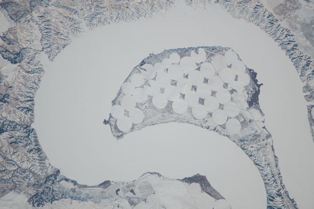
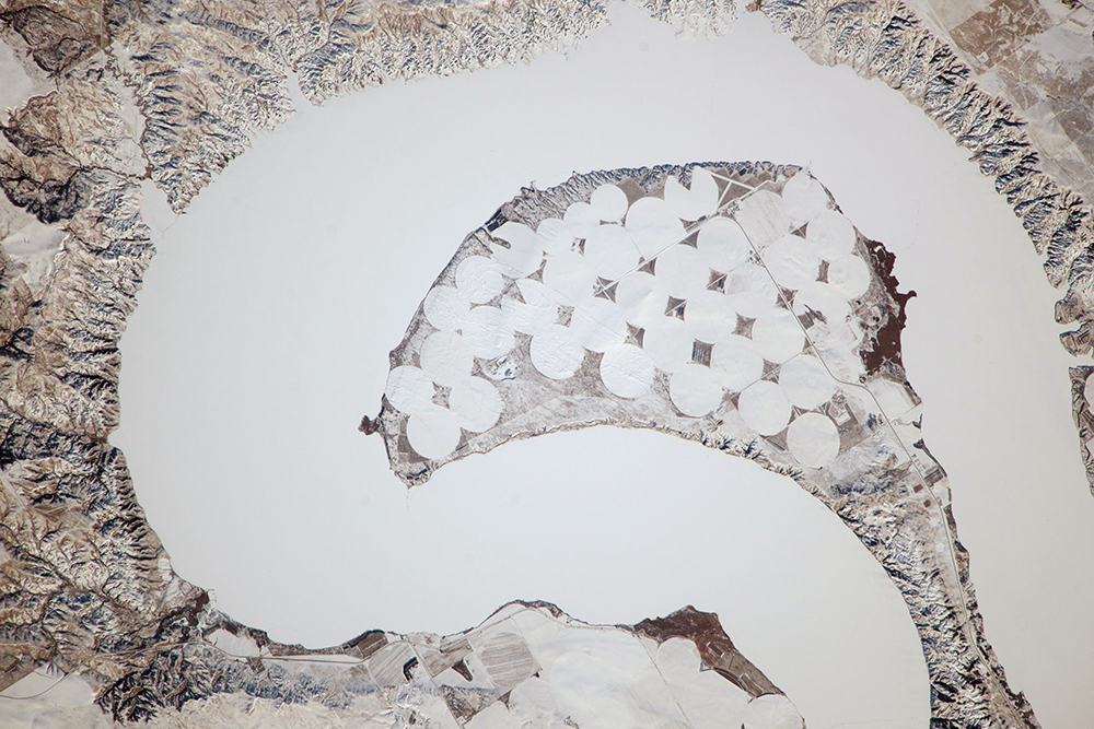
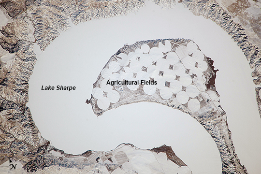
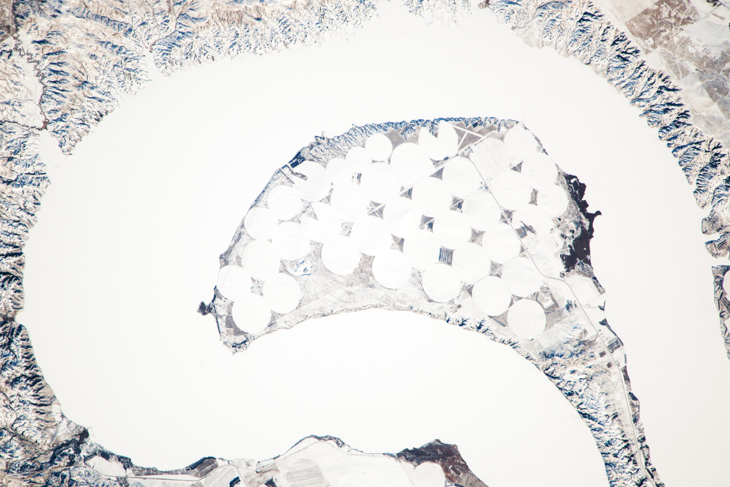
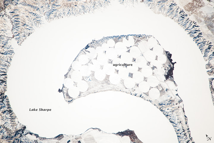
Image Caption: Lake Sharpe near Lower Brule, South Dakota
The Missouri River rises in the Rocky Mountains of western Montana, and flows generally to the southeast for approximately 3,767 km (2,341 miles) to its confluence with the Mississippi River north of St. Louis, Missouri - making it the longest river in North America. The river does not follow a straight southeasterly course along this distance, but includes may meander bends such as illustrated in this astronaut photograph from the International Space Station. This particular bend is occupied by Lake Sharpe, an approximately 130 km (80 miles) long reservoir formed behind the Big Bend Dam on the Missouri River. The lake surface is frozen and covered with snow, presenting a uniform white appearance in the image.
As meander bends develop, they tend to assume a distinctive U-shape when viewed from above. Over time, the river channel can continue to cut into the ends of the "U", eventually bringing them so close together that the river then cuts across the gap to achieve a shorter flow path, essentially short-circuiting or cutting off the meander bend. When this happens and the meander ceases to be part of the active river channel, it may become an oxbow lake. The distance across the narrow neck of land (image lower right) associated with this meander near Lower Brule, South Dakota is approximately 1 km (0.62 miles); however, as the river flow is controlled by the Big Bend Dam downstream, the natural process of meander cutoff has been significantly slowed.
The snow cover also highlights circular agricultural fields on the small peninsula within the meander bend. This type of field indicates center-pivot irrigation, where water is distributed from a central point radially outwards using sprinklers to cover the field area. Crops grown here include corn and soybeans according to data from the US Department of Agriculture.
