ISS037-E-719
| NASA Photo ID | ISS037-E-719 |
| Focal Length | 400mm |
| Date taken | 2013.09.13 |
| Time taken | 07:33:04 GMT |
Resolutions offered for this image:
1000 x 665 pixels 540 x 359 pixels 1440 x 960 pixels 720 x 480 pixels 4256 x 2832 pixels 640 x 426 pixels
1000 x 665 pixels 540 x 359 pixels 1440 x 960 pixels 720 x 480 pixels 4256 x 2832 pixels 640 x 426 pixels


Spacecraft nadir point: 38.6° N, 67.0° E
Photo center point: 39.6° N, 66.9° E
Photo center point by machine learning:
Photo center point: 39.6° N, 66.9° E
Photo center point by machine learning:
Nadir to Photo Center: North
Spacecraft Altitude: 221 nautical miles (409km)
Country or Geographic Name: | UZBEKISTAN |
Features: | SAMARKAND, ZERVASHAN R., JOMBOY |
| Features Found Using Machine Learning: | |
Cloud Cover Percentage: | 10 (1-10)% |
Sun Elevation Angle: | 55° |
Sun Azimuth: | 182° |
Camera: | Nikon D3S Electronic Still Camera |
Focal Length: | 400mm |
Camera Tilt: | 15 degrees |
Format: | 4256E: 4256 x 2832 pixel CMOS sensor, 36.0mm x 23.9mm, total pixels: 12.87 million, Nikon FX format |
Film Exposure: | |
| Additional Information | |
| Width | Height | Annotated | Cropped | Purpose | Links |
|---|---|---|---|---|---|
| 1000 pixels | 665 pixels | No | Yes | Earth From Space collection | Download Image |
| 540 pixels | 359 pixels | Yes | Yes | Earth From Space collection | Download Image |
| 1440 pixels | 960 pixels | No | No | NASA's Earth Observatory web site | Download Image |
| 720 pixels | 480 pixels | Yes | No | NASA's Earth Observatory web site | Download Image |
| 4256 pixels | 2832 pixels | No | No | Download Image | |
| 640 pixels | 426 pixels | No | No | Download Image |
Download Packaged File
Download a Google Earth KML for this Image
View photo footprint information
Download a GeoTIFF for this photo
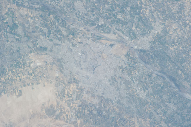
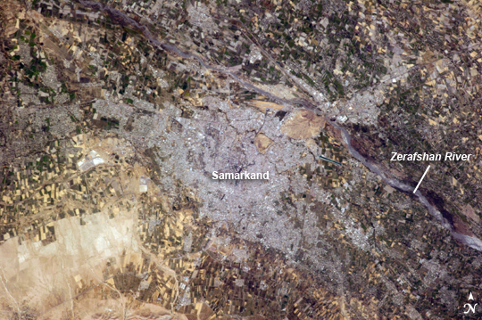
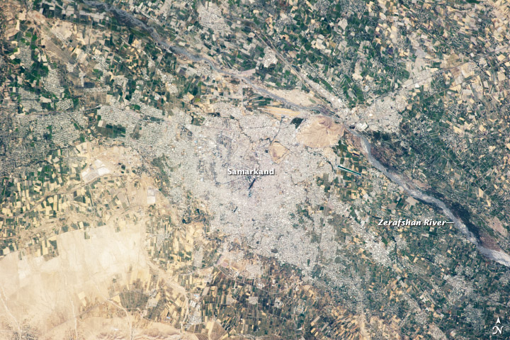
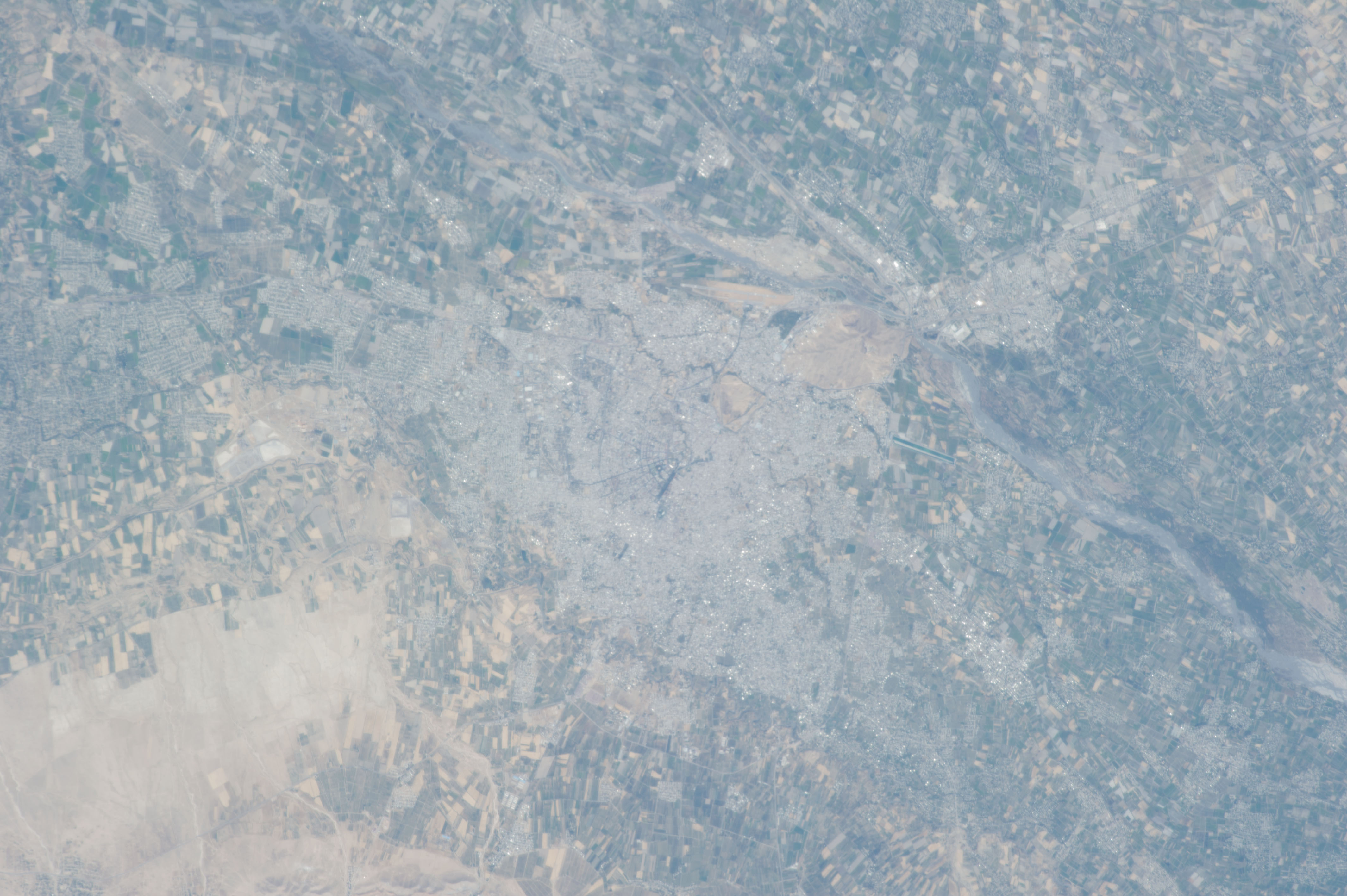
Image Caption: Samarkand, Uzbekistan
The historical Silk Road - or as some scholars prefer, Silk Routes (as there were several "roads") - provided trade routes between Asia and Europe from 206 BC; parts of the Silk Road are still used for transport of goods today. The city of Samarkand, featured in this astronaut photograph from the International Space Station, is one of the oldest and historically most important cities along the Road, occupying a central position between China and the Western nations of Europe. The city is thought to have been founded around 700 BC. In addition to its continual role as a trade center, many events have occurred in the city's long history, including conquering by Alexander the Great(329 BC) and Genghis Khan (1220); becoming the capital city of the empire of Tamerlane, or Timur (1370); the capital city of the Uzbek Soviet Socialist Republic from 1925-1930; and being added to the UNESCO World Heritage List in 2001.
Today, Samarkand is the second largest city in the Republic of Uzbekistan (formed in 1991). The urban area (image center) is located within a large oasis situated in the Zerafshan River Valley of southeastern Uzbekistan. Historical accounts of Samarkand describe it as a "paradise", and this favorable climate today still supports extensive agriculture; field are particularly evident to the southwest of the city (green - active; tan - fallow at image lower left). In keeping with its status as a World Heritage site, the city attracts many international visitors due to its preservation of historical and cultural monuments. As the capital of the Samarkand Province, it also serves as the regional government administrative center.
