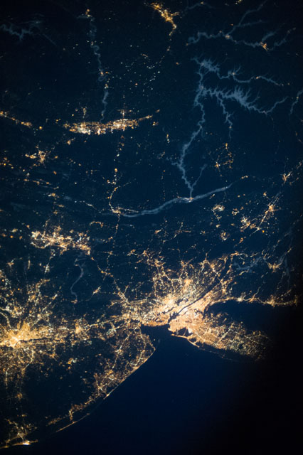
ISS037-E-1793
| NASA Photo ID | ISS037-E-1793 |
| Focal Length | 50mm |
| Date taken | 2013.09.20 |
| Time taken | 07:52:00 GMT |

Cloud masks available for this image:
Spacecraft nadir point: 40.9° N, 77.5° W
Photo center point: 41.0° N, 75.0° W
Photo center point by machine learning:
Photo center point: 41.0° N, 75.0° W
Photo center point by machine learning:
Nadir to Photo Center: East
Spacecraft Altitude: 220 nautical miles (407km)
Country or Geographic Name: | USA-NEW JERSEY |
Features: | NEW YORK-BALTIMORE, SCRANTON-WILKS-BARRE, EASTON AREAS AT NIGHT |
| Features Found Using Machine Learning: | |
Cloud Cover Percentage: | 10 (1-10)% |
Sun Elevation Angle: | -33° |
Sun Azimuth: | 53° |
Camera: | Nikon D3S Electronic Still Camera |
Focal Length: | 50mm |
Camera Tilt: | 34 degrees |
Format: | 4256E: 4256 x 2832 pixel CMOS sensor, 36.0mm x 23.9mm, total pixels: 12.87 million, Nikon FX format |
Film Exposure: | |
| Additional Information | |
| Width | Height | Annotated | Cropped | Purpose | Links |
|---|---|---|---|---|---|
| 2832 pixels | 4256 pixels | No | No | Download Image | |
| 426 pixels | 640 pixels | No | No | Download Image |
Download Packaged File
Download a Google Earth KML for this Image
View photo footprint information
Download a GeoTIFF for this photo
Image Caption: ISS037-E-001793 (20 Sept. 2013) --- One of three Expedition 37 crew members aboard the International Space Station on Sept. 20 photographed this night image showing several major cities and communities on the east coast and points west, toward the Great Lakes area. Long Island, NY is a tell-tale identifier in the lower right corner as it juts out into the Atlantic (partially obstructed by a close-up part of the orbital outpost), forming the estuary known as Long Island Sound. The New York metropolitan area is largely visible below the center of the frame.
