ISS036-E-39778
| NASA Photo ID | ISS036-E-39778 |
| Focal Length | 400mm |
| Date taken | 2013.09.03 |
| Time taken | 09:02:33 GMT |
Resolutions offered for this image:
1000 x 665 pixels 540 x 359 pixels 1440 x 960 pixels 720 x 480 pixels 4256 x 2832 pixels 640 x 426 pixels
1000 x 665 pixels 540 x 359 pixels 1440 x 960 pixels 720 x 480 pixels 4256 x 2832 pixels 640 x 426 pixels


Spacecraft nadir point: 44.0° N, 11.9° E
Photo center point: 42.2° N, 12.2° E
Photo center point by machine learning:
Photo center point: 42.2° N, 12.2° E
Photo center point by machine learning:
Nadir to Photo Center: South
Spacecraft Altitude: 220 nautical miles (407km)
Country or Geographic Name: | ITALY |
Features: | LAKE BRACCIANO, LAKE VICO, CAPRANICA, RONCIGLIONE, SUNGLINT |
| Features Found Using Machine Learning: | |
Cloud Cover Percentage: | 10 (1-10)% |
Sun Elevation Angle: | 44° |
Sun Azimuth: | 133° |
Camera: | Nikon D3S Electronic Still Camera |
Focal Length: | 400mm |
Camera Tilt: | 26 degrees |
Format: | 4256E: 4256 x 2832 pixel CMOS sensor, 36.0mm x 23.9mm, total pixels: 12.87 million, Nikon FX format |
Film Exposure: | |
| Additional Information | |
| Width | Height | Annotated | Cropped | Purpose | Links |
|---|---|---|---|---|---|
| 1000 pixels | 665 pixels | No | Yes | Earth From Space collection | Download Image |
| 540 pixels | 359 pixels | Yes | Yes | Earth From Space collection | Download Image |
| 1440 pixels | 960 pixels | No | No | NASA's Earth Observatory web site | Download Image |
| 720 pixels | 480 pixels | Yes | No | NASA's Earth Observatory web site | Download Image |
| 4256 pixels | 2832 pixels | No | No | Download Image | |
| 640 pixels | 426 pixels | No | No | Download Image |
Download Packaged File
Download a Google Earth KML for this Image
View photo footprint information
Download a GeoTIFF for this photo
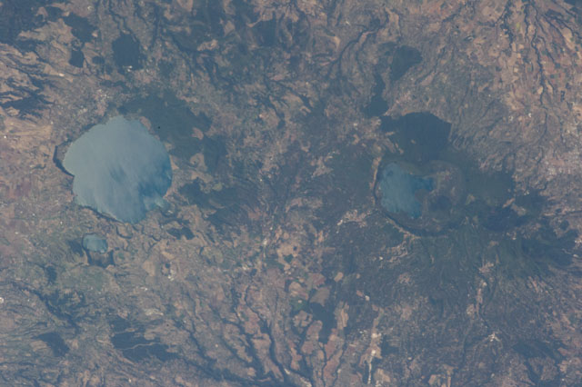
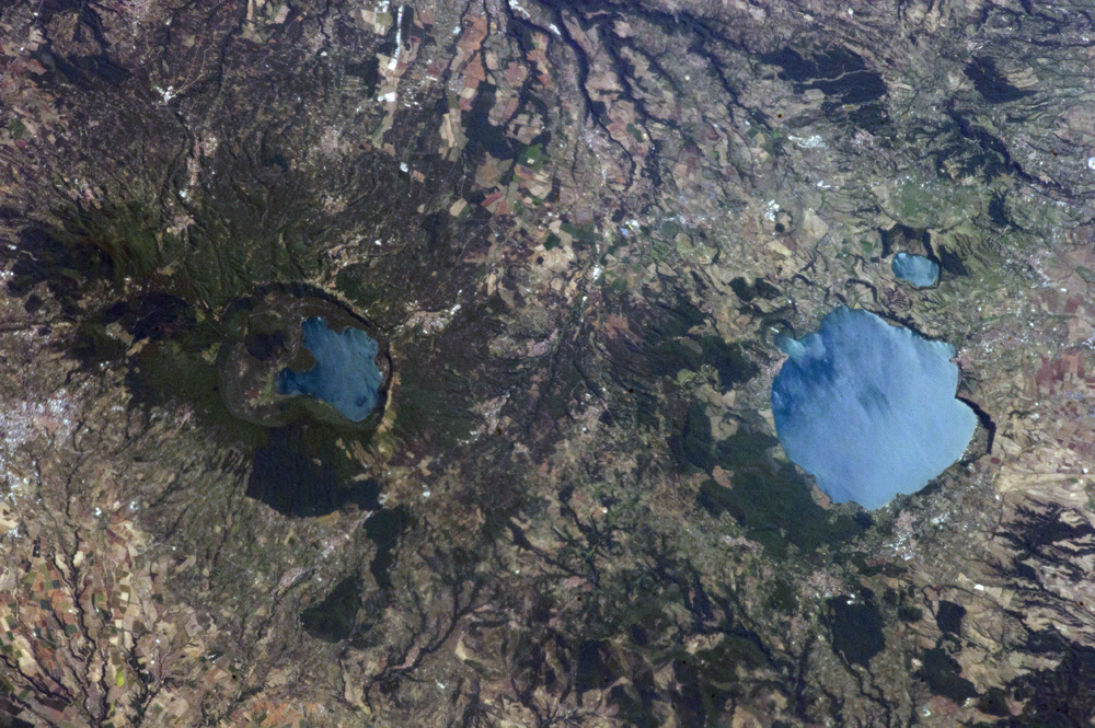
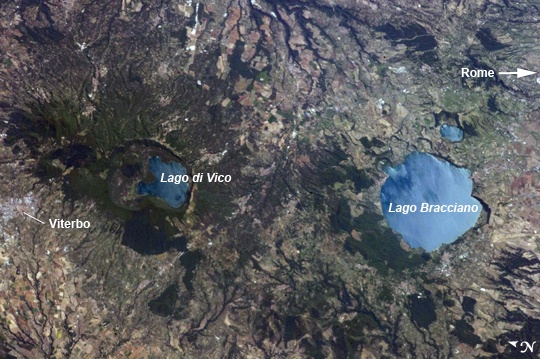
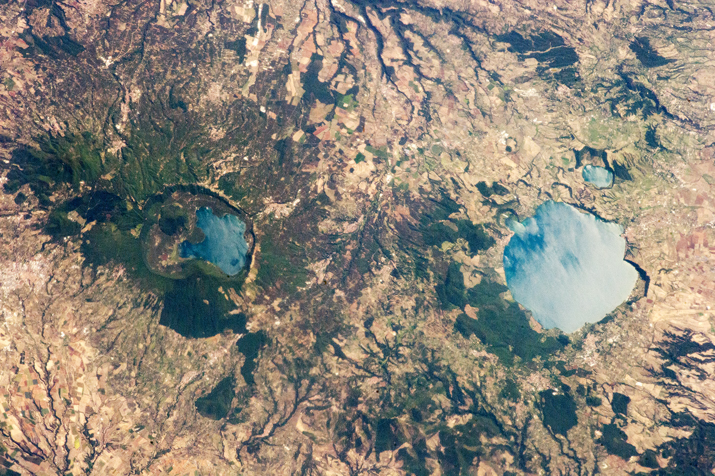
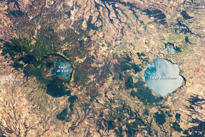
Image Caption: Caldera Lakes to the North of Rome, Italy
Note: This caption refers to the image versions labeled "NASA's Earth Observatory web site".
The Lazio region of central Italy has many landforms of volcanic origin, including several large lakes that mark the locations of ancient volcanoes. This astronaut photograph from the International Space Station highlights two such lakes, Lago di Vico and Lago Bracciano, located to the northwest of the capital city of Rome. Both lakes are located within calderas, large depressions that form after violent explosive eruptions empty a volcano's underlying magma chamber. Any remnants of the volcanic edifice can then collapse into the newly-formed void space, leading to the creation of large depressions. These depressions can then fill partially or completely with water, forming permanent lakes.
Lago Bracciano (image right) is the larger of the two lakes highlighted in the image; it is approximately 8 km wide at its widest point, and is located 32 km northwest of Rome. The volcanic activity that led to the formation of Lago Bracciano began approximately 600,000 years ago and continued to approximately 40,000 years ago as part of the formation of the Sabatini volcanic complex. While part of the lake formation was due to caldera collapse of part of a large magma chamber, the current depression was also formed by movement along numerous faults in the area- a process known as volcano-tectonic collapse.
Located approximately 24 km to the north-northwest of Lago Bracciano, Lago di Vico (image left) occupies part of a caldera associated with eruptive activity that began approximately 800,000 years ago and continued until approximately 90,000 years ago. The caldera formed largely by the catastrophic eruption of the ancestral Vico volcano approximately 200,000-150,000 years ago. The final phase of volcanic activity in the caldera led to the formation of a small lava cone in the NE quadrant known as Mount Venus.
The extent of the lakes of Bracciano and Vico are readily apparent in this image due to sunglint - light reflecting back towards the observer from the water surfaces. This reflection gives a mirror-like sheen to the water surfaces in the image. Dark green forested areas associated with parks are visible near both lakes, while light gray to white regions indicate built areas - such as the city of Viterbo at image left - and tilled fields (image top center).
