ISS036-E-2105
| NASA Photo ID | ISS036-E-2105 |
| Focal Length | 800mm |
| Date taken | 2013.05.18 |
| Time taken | 16:04:00 GMT |
Resolutions offered for this image:
1440 x 960 pixels 720 x 480 pixels 4256 x 2832 pixels 640 x 426 pixels
1440 x 960 pixels 720 x 480 pixels 4256 x 2832 pixels 640 x 426 pixels


Spacecraft nadir point: 49.1° N, 157.4° W
Photo center point: 55.4° N, 161.9° W
Photo center point by machine learning:
Photo center point: 55.4° N, 161.9° W
Photo center point by machine learning:
Nadir to Photo Center: Northwest
Spacecraft Altitude: 222 nautical miles (411km)
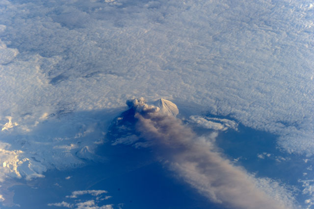
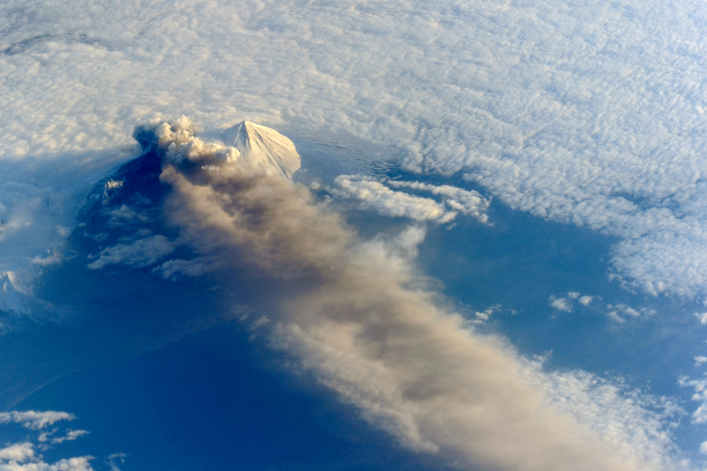
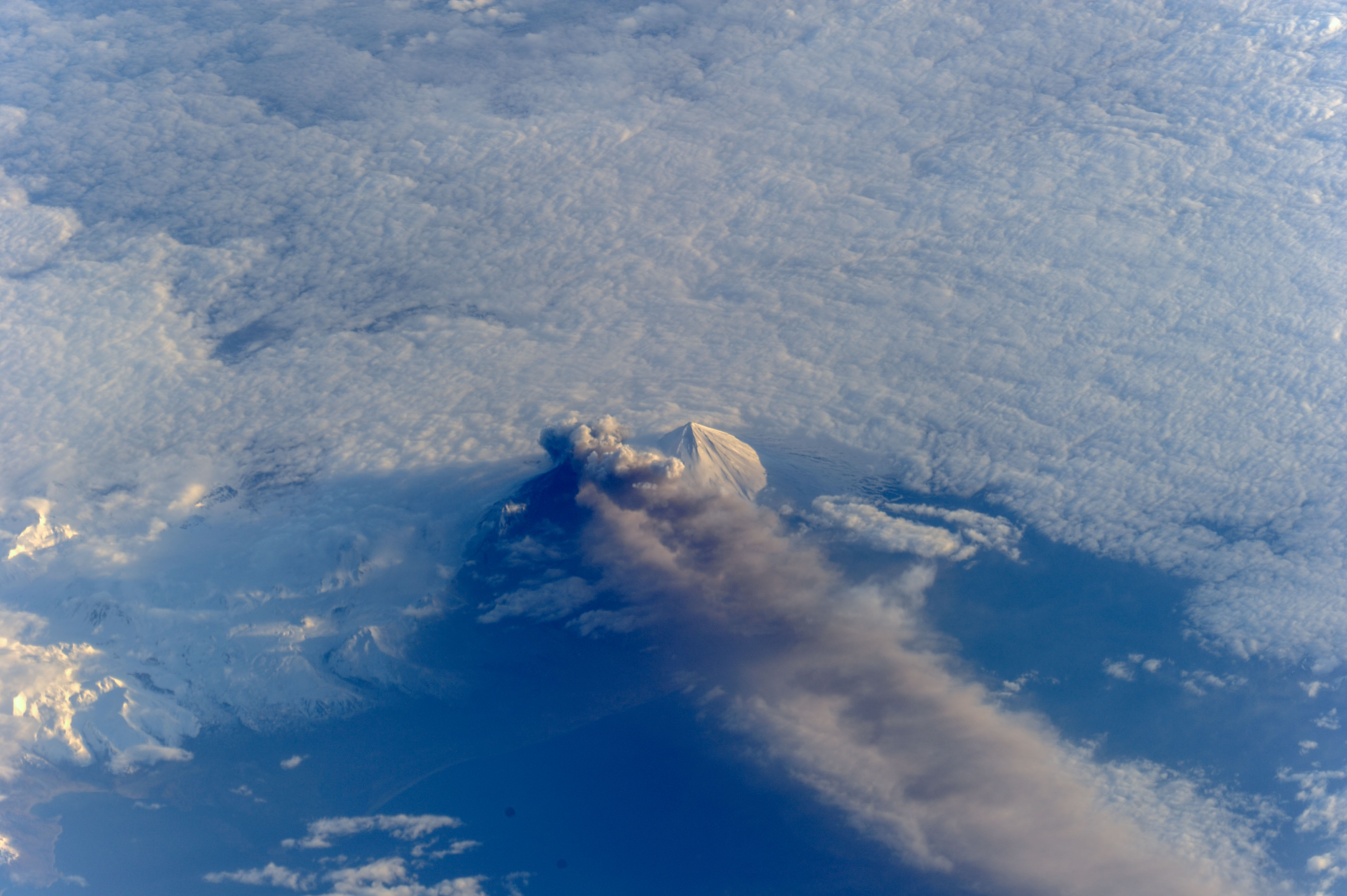
Country or Geographic Name: | USA-ALASKA |
Features: | MOUNT PAVLOF, ERUPTION PLUME, PAVLOF SISTER |
| Features Found Using Machine Learning: | |
Cloud Cover Percentage: | 10 (1-10)% |
Sun Elevation Angle: | 11° |
Sun Azimuth: | 73° |
Camera: | Nikon D3S Electronic Still Camera |
Focal Length: | 800mm |
Camera Tilt: | High Oblique |
Format: | 4256E: 4256 x 2832 pixel CMOS sensor, 36.0mm x 23.9mm, total pixels: 12.87 million, Nikon FX format |
Film Exposure: | |
| Additional Information | |
| Width | Height | Annotated | Cropped | Purpose | Links |
|---|---|---|---|---|---|
| 1440 pixels | 960 pixels | No | Yes | NASA's Earth Observatory web site | Download Image |
| 720 pixels | 480 pixels | Yes | Yes | NASA's Earth Observatory web site | Download Image |
| 4256 pixels | 2832 pixels | No | No | Download Image | |
| 640 pixels | 426 pixels | No | No | Download Image |
Download Packaged File
Download a Google Earth KML for this Image
View photo footprint information
Download a GeoTIFF for this photo
Image Caption: ISS036-E-002105 (17 May 2013) --- The second Alaska volcano to erupt in May was captured by one of the Expedition 36 crew members on the International Space Station. Pavlof volcano, in the Aleutian Islands about 625 miles (1,000 kilometers) southwest of Anchorage, Alaska, jetted lava into the air and spewed an ash cloud 20,000 feet (6,000 meters) high
