ISS035-E-18006
| NASA Photo ID | ISS035-E-18006 |
| Focal Length | 400mm |
| Date taken | 2013.04.08 |
| Time taken | 20:30:27 GMT |
Resolutions offered for this image:
1000 x 643 pixels 540 x 347 pixels 2128 x 1416 pixels 720 x 480 pixels 4256 x 2832 pixels 640 x 426 pixels
1000 x 643 pixels 540 x 347 pixels 2128 x 1416 pixels 720 x 480 pixels 4256 x 2832 pixels 640 x 426 pixels


Cloud masks available for this image:
Spacecraft nadir point: 18.8° S, 67.9° W
Photo center point: 19.1° S, 68.5° W
Photo center point by machine learning:
Photo center point: 19.1° S, 68.5° W
Photo center point by machine learning:
Nadir to Photo Center: Southwest
Spacecraft Altitude: 226 nautical miles (419km)
Country or Geographic Name: | BOLIVIA |
Features: | TATA SABAYA VOLCANO, DEBRIS AVALANCHE, SALAR DE COIPASA |
| Features Found Using Machine Learning: | |
Cloud Cover Percentage: | 10 (1-10)% |
Sun Elevation Angle: | 26° |
Sun Azimuth: | 289° |
Camera: | Nikon D3S Electronic Still Camera |
Focal Length: | 400mm |
Camera Tilt: | 10 degrees |
Format: | 4256E: 4256 x 2832 pixel CMOS sensor, 36.0mm x 23.9mm, total pixels: 12.87 million, Nikon FX format |
Film Exposure: | |
| Additional Information | |
| Width | Height | Annotated | Cropped | Purpose | Links |
|---|---|---|---|---|---|
| 1000 pixels | 643 pixels | No | Yes | Earth From Space collection | Download Image |
| 540 pixels | 347 pixels | Yes | Yes | Earth From Space collection | Download Image |
| 2128 pixels | 1416 pixels | No | Yes | NASA's Earth Observatory web site | Download Image |
| 720 pixels | 480 pixels | Yes | Yes | NASA's Earth Observatory web site | Download Image |
| 4256 pixels | 2832 pixels | No | No | Download Image | |
| 640 pixels | 426 pixels | No | No | Download Image |
Download Packaged File
Download a Google Earth KML for this Image
View photo footprint information
Download a GeoTIFF for this photo
Image Caption: Tata Sabaya Volcano, Bolivia
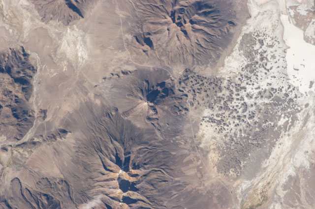
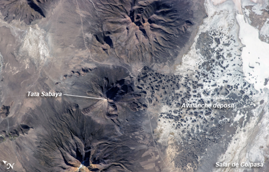
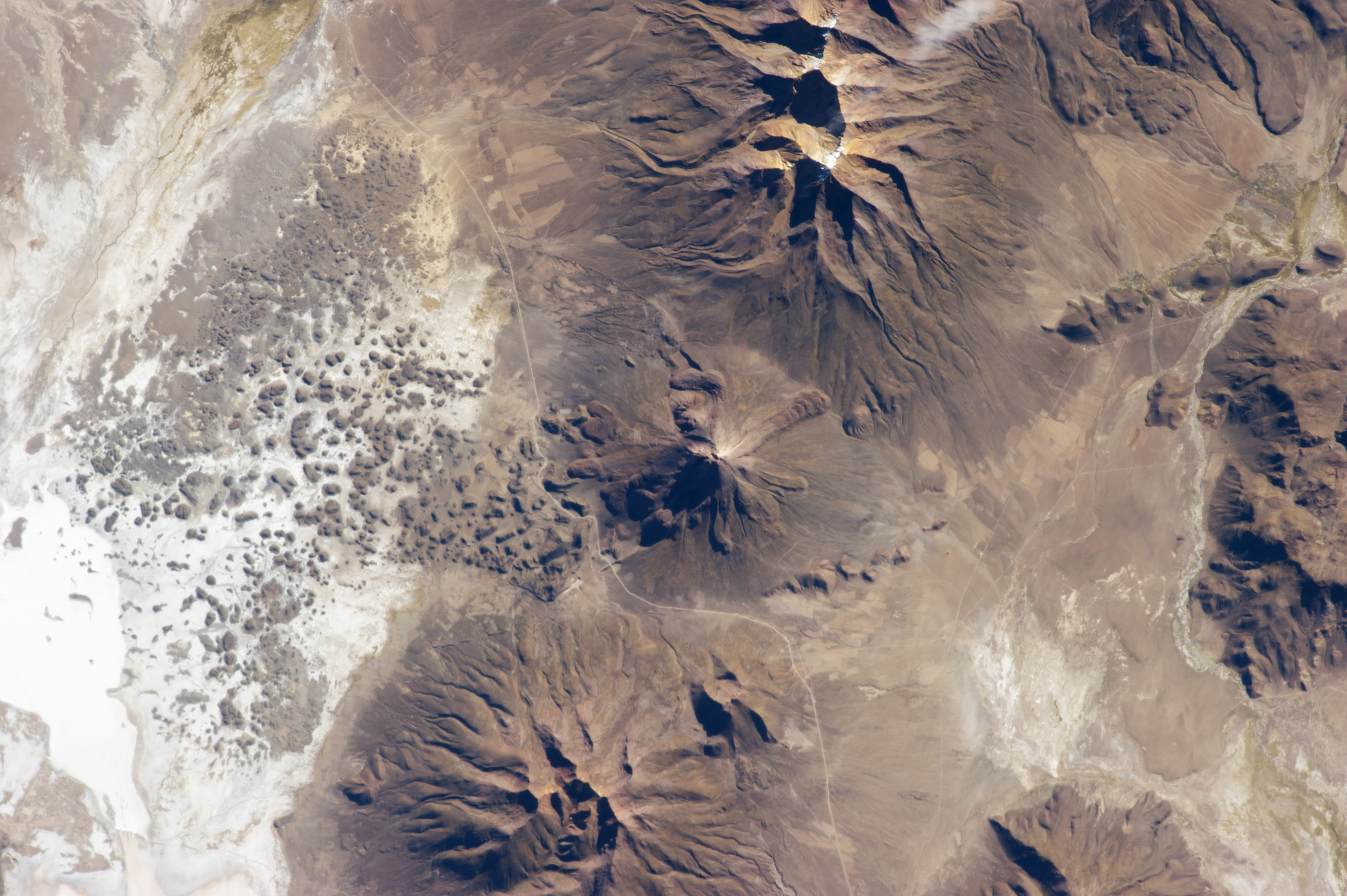
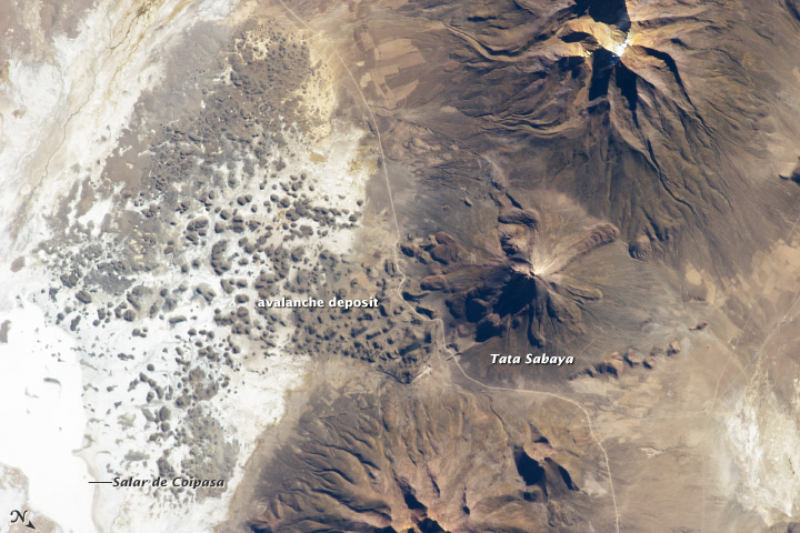
Tata Sabaya, a stratovolcano located in the Altiplano region of Bolivia, rises to a summit elevation of 5430 meters above sea level. While its current form is that of a youthful stratovolcano, the regional geological evidence indicates an older, eventful history. Prior to approximately 12,000 years ago (during the late Pleistocene Epoch) a large debris avalanche was formed by collapse of the ancestral Tata Sabaya volcano. Debris from the avalanche swept into the nearby Salar de Coipasa -at that time filled with a lake larger than today - significantly changing its northwestern coastline. Timing of the event is obtained from tufa deposits formed on debris islands during a high stand of the Coipasa lake - illustrating the geological principle of cross-cutting relationships, in that the debris avalanche had to have occurred before the tufa deposits were formed in the lake.
The Tata Sabaya stratovolcano is located at image center in this astronaut photograph from the International Space Station. Several young lava flows are visible on the northwestern and western flanks of the volcano. Peaks visible to the northeast and southwest appear to be volcanoes as well, but unlike Tata Sabaya there is no record of recent activity from either of them (according to the Smithsonian National Museum of Natural History's Global Volcanism Program). As the climate of the Altiplano became more arid and the Coipasa Lake shrank, much of the hummocky terrain of the debris avalanche became exposed over an area of more than 300 square kilometers. The hummocky terrain is clearly visible at image right. White salt deposits of the salar surround many of the individual hummocks, making them "islands" once again.
