ISS034-E-70070
| NASA Photo ID | ISS034-E-70070 |
| Focal Length | 800mm |
| Date taken | 2013.01.06 |
| Time taken | 15:14:49 GMT |
Resolutions offered for this image:
1000 x 1340 pixels 540 x 724 pixels 1440 x 960 pixels 720 x 480 pixels 720 x 640 pixels 6048 x 4032 pixels 640 x 427 pixels
1000 x 1340 pixels 540 x 724 pixels 1440 x 960 pixels 720 x 480 pixels 720 x 640 pixels 6048 x 4032 pixels 640 x 427 pixels


Cloud masks available for this image:
Spacecraft nadir point: 18.3° N, 20.7° E
Photo center point: 19.1° N, 19.2° E
Photo center point by machine learning:
Photo center point: 19.1° N, 19.2° E
Photo center point by machine learning:
Nadir to Photo Center: Northwest
Spacecraft Altitude: 216 nautical miles (400km)
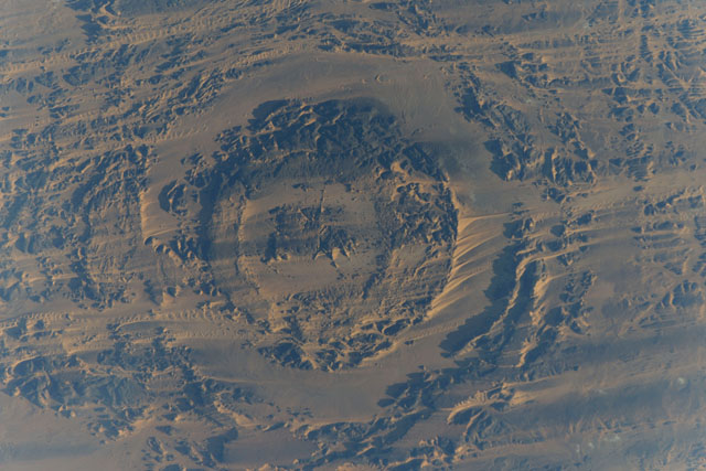
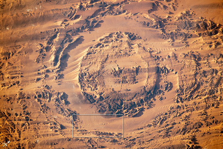
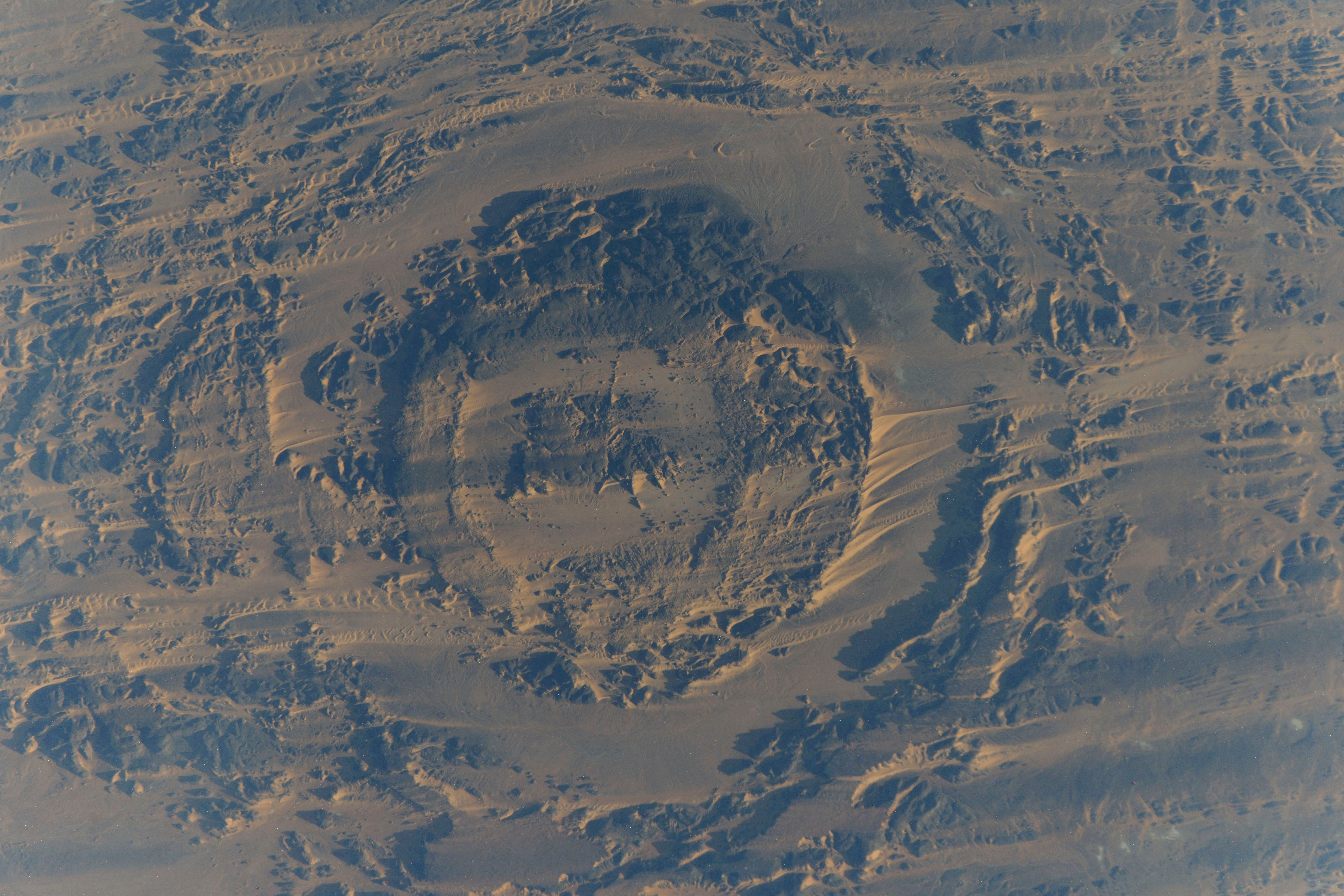
Country or Geographic Name: | CHAD |
Features: | AORUNGA CRATER, SAND DUNES, SAHARA DESERT |
| Features Found Using Machine Learning: | |
Cloud Cover Percentage: | 10 (1-10)% |
Sun Elevation Angle: | 12° |
Sun Azimuth: | 241° |
Camera: | Nikon D3X Electronic Still Camera |
Focal Length: | 800mm |
Camera Tilt: | 25 degrees |
Format: | 6048E: 6048 x 4032 pixel CMOS sensor, 35.9mm x 24.0mm, total pixels: 25.72 million, Nikon FX format |
Film Exposure: | |
| Additional Information | Russian imagery |
| Width | Height | Annotated | Cropped | Purpose | Links |
|---|---|---|---|---|---|
| 1000 pixels | 1340 pixels | Yes | Yes | Earth From Space collection | Download Image |
| 540 pixels | 724 pixels | Yes | Yes | Earth From Space collection | Download Image |
| 1440 pixels | 960 pixels | No | No | NASA's Earth Observatory web site | Download Image |
| 720 pixels | 480 pixels | Yes | No | NASA's Earth Observatory web site | Download Image |
| 720 pixels | 640 pixels | Yes | Yes | NASA's Earth Observatory web site | Download Image |
| 6048 pixels | 4032 pixels | No | No | Download Image | |
| 640 pixels | 427 pixels | No | No | Download Image |
Download Packaged File
Download a Google Earth KML for this Image
View photo footprint information
Download a GeoTIFF for this photo
Image Caption: Dune movement, Sahara Desert, Chad, 2003-2013
Note: This caption refers to the image versions labeled "NASA's Earth Observatory web site".
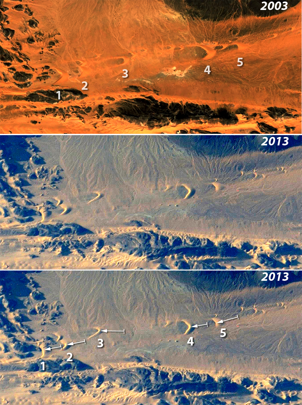
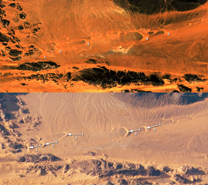
Images of the central Sahara Desert taken by crews on the International Space Station (ISS) often include sand dunes. This sequence of images features a series of horn-shaped "barchan" dunes clustered in a narrow corridor between lines of dark-toned hills, the horns pointing in the direction of dune migration, that is, from NNW to SSE, under the influence of the prevailing winds. Thick zones of small, rippled, light-toned dunes can be seen at the bottom of the images, with dry river channels in the center and upper parts.
The larger dunes maintain their shape and size well enough to be confidently identified in these images taken nine years apart. The 2003 image was obtained from Google Earth ((c) 2013 CNES/Spot Image, (c) 2013 DigitalGlobe); while the 2013 image was taken by crews on board the ISS. Comparison of the 2003 (top) and 2013 images (center and bottom) shows that five larger dunes appear to have moved, as seen against fixed points such as hills and channels. Measurements show that the dunes have moved hundreds of meters (from left to right: 1: 316m, 2: 275m, 3: 405m, 4: 318m, and 5: 381m). Arrows in the bottom image show the direction and distance of movement.
Dunes 3 and 5 have moved furthest--following to the well-known phenomenon that smaller dune size is related to faster movement. The smallest dunes move so fast that they cannot be tracked over a decade, partly because they are absorbed by larger dunes, partly because they move into hilly terrain and break up, and partly because new small dunes are "shed" from the horns of the larger dunes.
This is the kind of environmental comparison possible from comparative imagery taken over long time periods. The value of knowledge gained from such comparisons is manyfold. Where large masses of sand move across highways or into farm fields, as is common on the edges of deserts, they cause great environmental damage and cost. It is now possible to predict when dunes are likely to cause such damage so that mitigation efforts can be put in place.
Note: This caption refers to the image versions labeled "NASA's Earth Observatory web site".
Images of the central Sahara Desert taken by crews on the International Space Station (ISS) often include sand dunes. This sequence of images features a series of horn-shaped "barchan" dunes clustered in a narrow corridor between lines of dark-toned hills, the horns pointing in the direction of dune migration, that is, from NNW to SSE, under the influence of the prevailing winds. Thick zones of small, rippled, light-toned dunes can be seen at the bottom of the images, with dry river channels in the center and upper parts.
The larger dunes maintain their shape and size well enough to be confidently identified in these images taken nine years apart. The 2003 image was obtained from Google Earth ((c) 2013 CNES/Spot Image, (c) 2013 DigitalGlobe); while the 2013 image was taken by crews on board the ISS. Comparison of the 2003 (top) and 2013 images (center and bottom) shows that five larger dunes appear to have moved, as seen against fixed points such as hills and channels. Measurements show that the dunes have moved hundreds of meters (from left to right: 1: 316m, 2: 275m, 3: 405m, 4: 318m, and 5: 381m). Arrows in the bottom image show the direction and distance of movement.
Dunes 3 and 5 have moved furthest--following to the well-known phenomenon that smaller dune size is related to faster movement. The smallest dunes move so fast that they cannot be tracked over a decade, partly because they are absorbed by larger dunes, partly because they move into hilly terrain and break up, and partly because new small dunes are "shed" from the horns of the larger dunes.
This is the kind of environmental comparison possible from comparative imagery taken over long time periods. The value of knowledge gained from such comparisons is manyfold. Where large masses of sand move across highways or into farm fields, as is common on the edges of deserts, they cause great environmental damage and cost. It is now possible to predict when dunes are likely to cause such damage so that mitigation efforts can be put in place.
