ISS034-E-48455

| NASA Photo ID | ISS034-E-48455 |
| Focal Length | 400mm |
| Date taken | 2013.02.14 |
| Time taken | 21:26:23 GMT |
Resolutions offered for this image:
665 x 1000 pixels 359 x 540 pixels 1000 x 1503 pixels 720 x 1082 pixels 2832 x 4256 pixels 426 x 640 pixels
665 x 1000 pixels 359 x 540 pixels 1000 x 1503 pixels 720 x 1082 pixels 2832 x 4256 pixels 426 x 640 pixels


Cloud masks available for this image:
Spacecraft nadir point: 46.4° N, 55.3° W
Photo center point: 40.9° N, 73.1° W
Photo center point by machine learning:
Photo center point: 40.9° N, 73.1° W
Photo center point by machine learning:
Nadir to Photo Center: West
Spacecraft Altitude: 222 nautical miles (411km)
Country or Geographic Name: | USA-NEW YORK |
Features: | LONG ISLAND, CAPE COD, SUNGLINT, BLOCK ISLAND, BUZZARDS BAY, ATMOSPHERIC LIMB |
| Features Found Using Machine Learning: | PAN- |
Cloud Cover Percentage: | 25 (11-25)% |
Sun Elevation Angle: | -4° |
Sun Azimuth: | 256° |
Camera: | Nikon D3S Electronic Still Camera |
Focal Length: | 400mm |
Camera Tilt: | High Oblique |
Format: | 4256E: 4256 x 2832 pixel CMOS sensor, 36.0mm x 23.9mm, total pixels: 12.87 million, Nikon FX format |
Film Exposure: | |
| Additional Information | |
| Width | Height | Annotated | Cropped | Purpose | Links |
|---|---|---|---|---|---|
| 665 pixels | 1000 pixels | No | Yes | Earth From Space collection | Download Image |
| 359 pixels | 540 pixels | Yes | Yes | Earth From Space collection | Download Image |
| 1000 pixels | 1503 pixels | No | No | NASA's Earth Observatory web site | Download Image |
| 720 pixels | 1082 pixels | Yes | No | NASA's Earth Observatory web site | Download Image |
| 2832 pixels | 4256 pixels | No | No | Download Image | |
| 426 pixels | 640 pixels | No | No | Download Image |
Download Packaged File
Download a Google Earth KML for this Image
View photo footprint information
Download a GeoTIFF for this photo
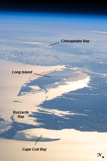
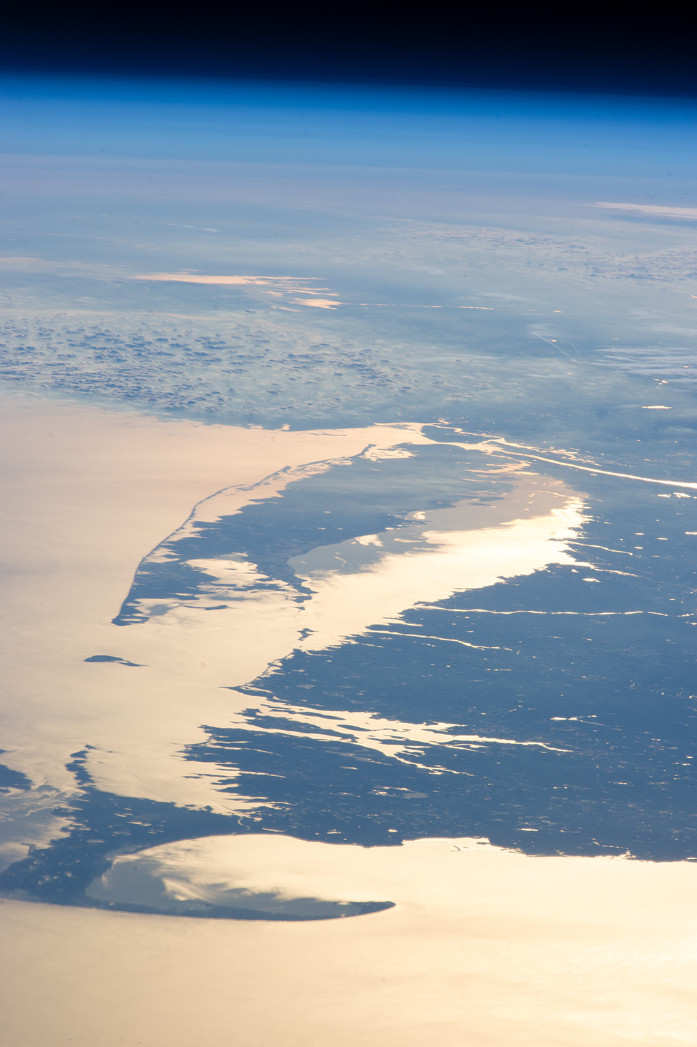
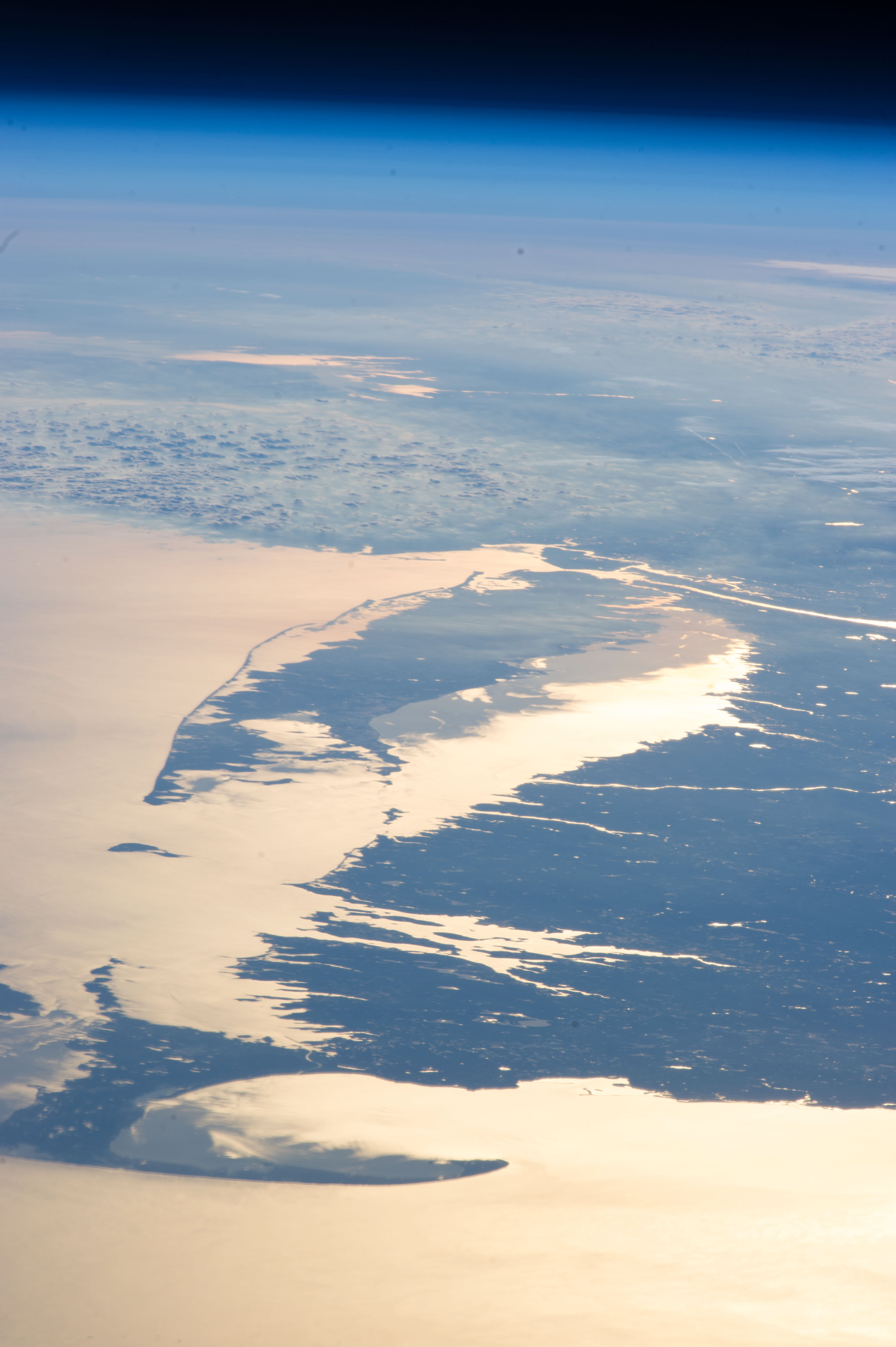
Image Caption: Northeastern USA Coastline in Sunglint
Looking out at the Earth's surface from the International Space Station (ISS), astronauts frequently observe sunglint highlighting both ocean and inland water surfaces. The Atlantic Ocean, including Cape Cod Bay and Buzzards Bay along the coastlines of the states of Massachusetts and Rhode Island has a burnished, mirror-like appearance in this image. This is due to sunlight reflected off the water surface back towards the astronaut-photographer on the ISS. The peak reflection point is towards the right side of the image, lending the waters of Long Island Sound (at image center, to the north of Long Island) and the upper Massachusetts coastline an even brighter appearance.
Sunglint also illuminates surface waters of Chesapeake Bay (image top center) located over 400 km to the southwest of the tip of Long Island. This suggests that the Sun was low on the horizon due to the observed extent of the sunglint effect. The time of image acquisition, approximately 4:26 PM Eastern Standard Time confirms that the image was taken approximately 1 hour before local sunset. There is little in the image to indicate that the region was still recovering from a major winter storm which dropped almost one meter of snow over much of the northeastern USA less than one week earlier.
The high viewing angle from the ISS also allows the Earth's curvature, or limb, to be seen; blue atmospheric layers gradually fade into the darkness of space across the top part of the image. Low clouds near Cape Cod, Long Island, and further down the Atlantic coastline cast shadows over the water surfaces, reducing the sunglint in some areas.
