ISS034-E-27139
| NASA Photo ID | ISS034-E-27139 |
| Focal Length | 180mm |
| Date taken | 2013.01.10 |
| Time taken | 05:43:48 GMT |
Resolutions offered for this image:
1000 x 665 pixels 540 x 359 pixels 1440 x 960 pixels 720 x 480 pixels 4256 x 2832 pixels 640 x 426 pixels
1000 x 665 pixels 540 x 359 pixels 1440 x 960 pixels 720 x 480 pixels 4256 x 2832 pixels 640 x 426 pixels


Cloud masks available for this image:
Spacecraft nadir point: 28.7° N, 131.5° E
Photo center point: 31.5° N, 130.8° E
Photo center point by machine learning:
Photo center point: 31.5° N, 130.8° E
Photo center point by machine learning:
Nadir to Photo Center: North
Spacecraft Altitude: 214 nautical miles (396km)
Country or Geographic Name: | JAPAN |
Features: | KYUSHU, SAKURAJIMA VOLCANO, PLUME, KAGOSHIMA BAY, KAGOSHIMA, KIRISHIMA |
| Features Found Using Machine Learning: | |
Cloud Cover Percentage: | 10 (1-10)% |
Sun Elevation Angle: | 29° |
Sun Azimuth: | 218° |
Camera: | Nikon D3S Electronic Still Camera |
Focal Length: | 180mm |
Camera Tilt: | 39 degrees |
Format: | 4256E: 4256 x 2832 pixel CMOS sensor, 36.0mm x 23.9mm, total pixels: 12.87 million, Nikon FX format |
Film Exposure: | |
| Additional Information | |
| Width | Height | Annotated | Cropped | Purpose | Links |
|---|---|---|---|---|---|
| 1000 pixels | 665 pixels | No | Yes | Earth From Space collection | Download Image |
| 540 pixels | 359 pixels | Yes | Yes | Earth From Space collection | Download Image |
| 1440 pixels | 960 pixels | No | Yes | NASA's Earth Observatory web site | Download Image |
| 720 pixels | 480 pixels | Yes | Yes | NASA's Earth Observatory web site | Download Image |
| 4256 pixels | 2832 pixels | No | No | Download Image | |
| 640 pixels | 426 pixels | No | No | Download Image |
Download Packaged File
Download a Google Earth KML for this Image
View photo footprint information
Download a GeoTIFF for this photo
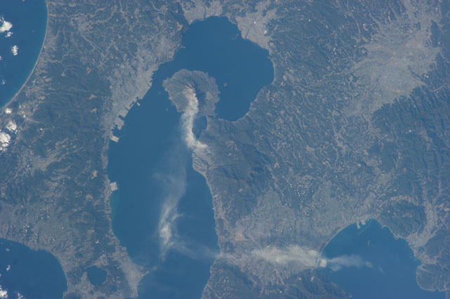
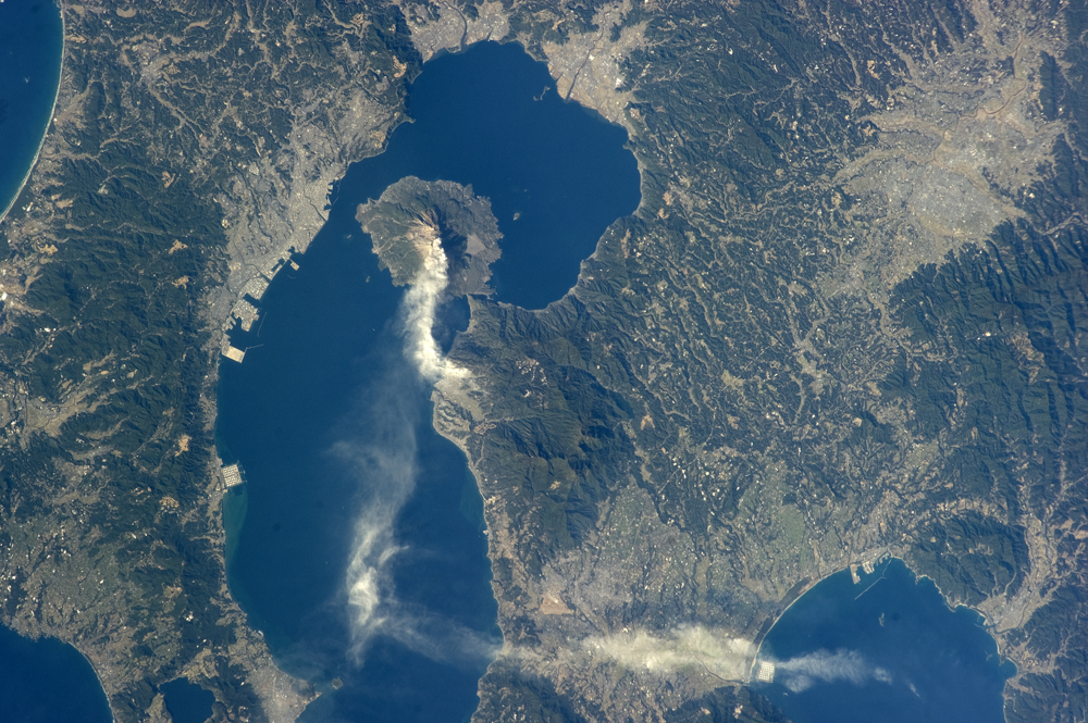
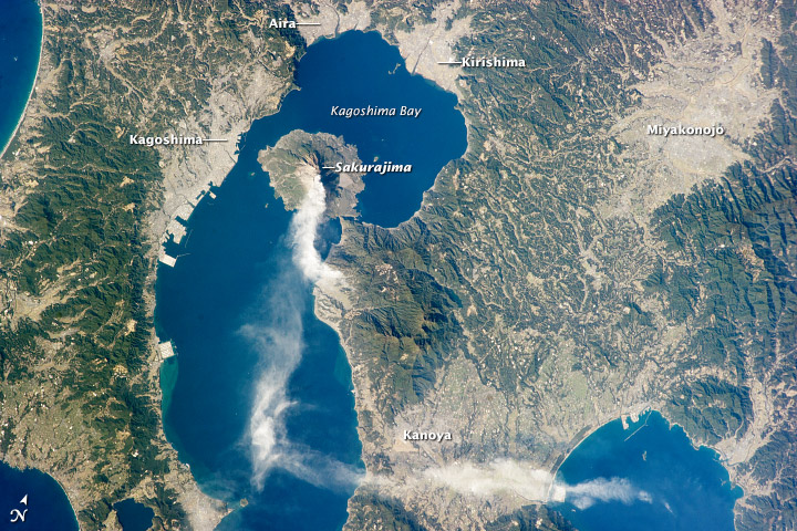
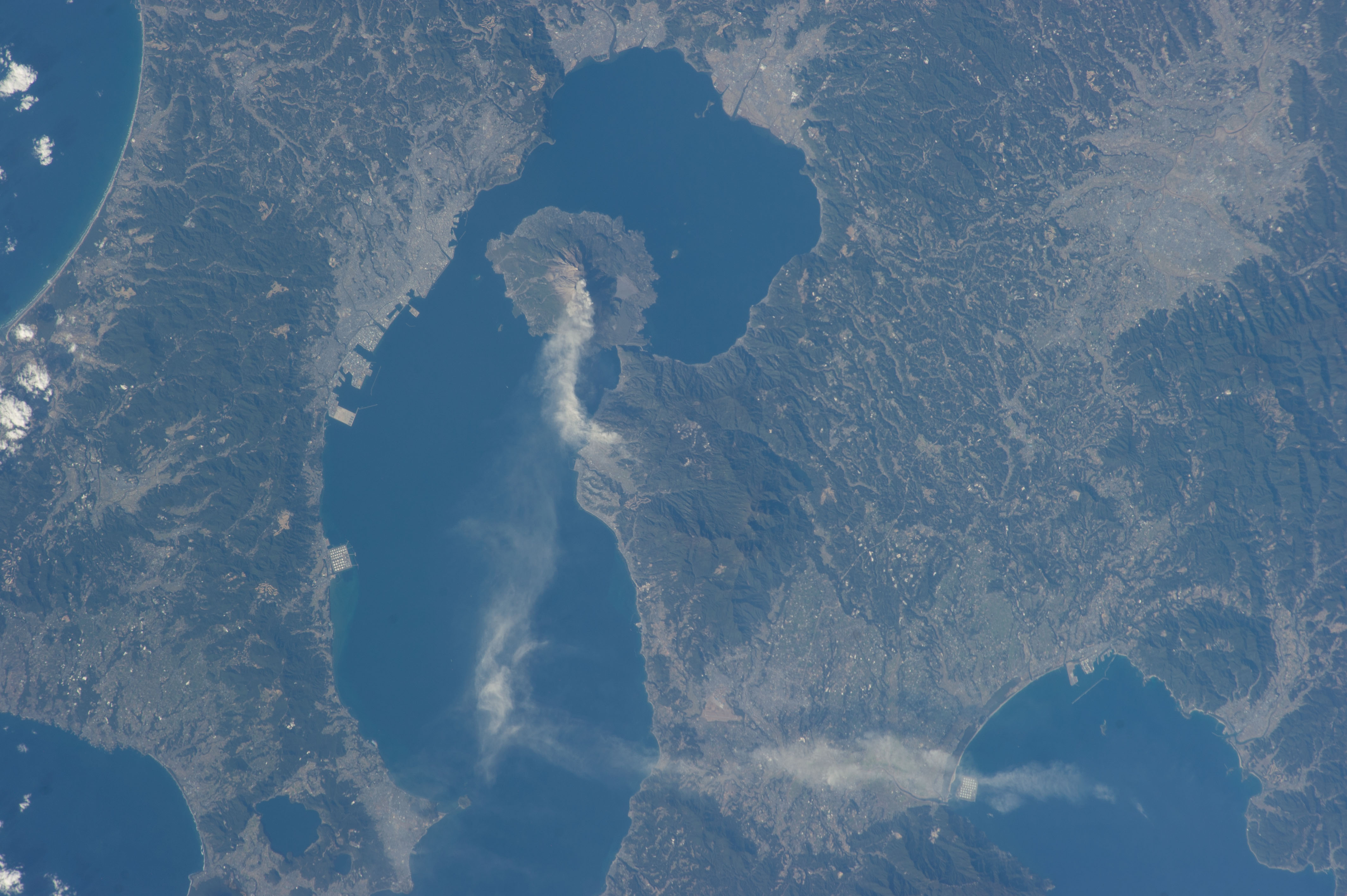
Image Caption: Sakurajima Volcano, Kyushu, Japan
This astronaut photograph taken from the International Space Station highlights Sakurajima, one of Japan's most active volcanoes (image center). There are several eruption craters near the 1,117 meter summit of Sakurajima; Kita-dake to the north last erupted approximately 5000 years ago, while Minami-dake and Showa crater to the south have been the site of frequent eruptions since at least the 8th century. The ash plume visible near the volcano summit and extending to the southeast may have originated from either Minami-dake or Showa craters. Sakurajima began forming approximately 13,000 years ago; prior to 1914, the volcano was an island in Kagoshima Bay--it was joined to the mainland by volcanic material following a major eruption in 1914.
The image highlights the proximity of several large urban areas (Aira, Kagoshima, Kanoya, Kirishima, and Miyakonojo are readily visible) to Sakurajima. This has prompted studies of potential health hazards presented by the volcanic ash (Hillman et al. 2012), which are particularly important if more powerful explosive eruptive activity resumes at the volcano. The Tokyo Volcanic Ash Advisory Center (VAAC //ds.data.jma.go.jp/svd/vaac/data/index.html) of the Japan Meteorological Agency issues advisories when eruptions occur. An advisory on the activity captured in this image was issued less than one hour before the astronaut took the photograph, by which time the plume tail had encountered northeast-trending upper-level winds (image bottom center).
Reference: Hillman, S.E., Horwell, C.J., Densmore, A.L., Damby, D.E., Fubini, B., Ishimine, Y., and Tomatis, M. (2012) Sakurajima volcano: a physico-chemical study of the health consequences of long-term exposure to volcanic ash, Bulletin of Volcanology, 74:913-930 (DOI: 10.1007/s00445-012-0575-3).
