ISS033-E-22378
| NASA Photo ID | ISS033-E-22378 |
| Focal Length | 28mm |
| Date taken | 2012.11.17 |
| Time taken | 15:47:29 GMT |
Resolutions offered for this image:
1000 x 1230 pixels 540 x 664 pixels 1440 x 1440 pixels 720 x 720 pixels 4256 x 2832 pixels 640 x 426 pixels
1000 x 1230 pixels 540 x 664 pixels 1440 x 1440 pixels 720 x 720 pixels 4256 x 2832 pixels 640 x 426 pixels

Cloud masks available for this image:
Spacecraft nadir point: 40.2° N, 76.6° W
Photo center point: 40.0° N, 77.5° W
Photo center point by machine learning:
Photo center point: 40.0° N, 77.5° W
Photo center point by machine learning:
Nadir to Photo Center: West
Spacecraft Altitude: 225 nautical miles (417km)
Country or Geographic Name: | USA-PENNSYLVANIA |
Features: | APPALACHIAN MTS., CHESAPEAKE BAY, ISS, GLINT, LAKE ERIE |
| Features Found Using Machine Learning: | |
Cloud Cover Percentage: | 10 (1-10)% |
Sun Elevation Angle: | 29° |
Sun Azimuth: | 163° |
Camera: | Nikon D3S Electronic Still Camera |
Focal Length: | 28mm |
Camera Tilt: | 14 degrees |
Format: | 4256E: 4256 x 2832 pixel CMOS sensor, 36.0mm x 23.9mm, total pixels: 12.87 million, Nikon FX format |
Film Exposure: | |
| Additional Information | |
| Width | Height | Annotated | Cropped | Purpose | Links |
|---|---|---|---|---|---|
| 1000 pixels | 1230 pixels | No | Yes | Earth From Space collection | Download Image |
| 540 pixels | 664 pixels | Yes | Yes | Earth From Space collection | Download Image |
| 1440 pixels | 1440 pixels | No | Yes | NASA's Earth Observatory web site | Download Image |
| 720 pixels | 720 pixels | Yes | Yes | NASA's Earth Observatory web site | Download Image |
| 4256 pixels | 2832 pixels | No | No | Download Image | |
| 640 pixels | 426 pixels | No | No | Download Image |
Download Packaged File
Download a Google Earth KML for this Image
View photo footprint information
Download a GeoTIFF for this photo
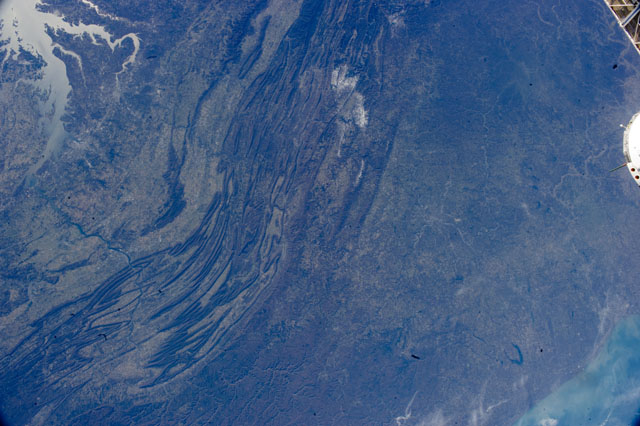
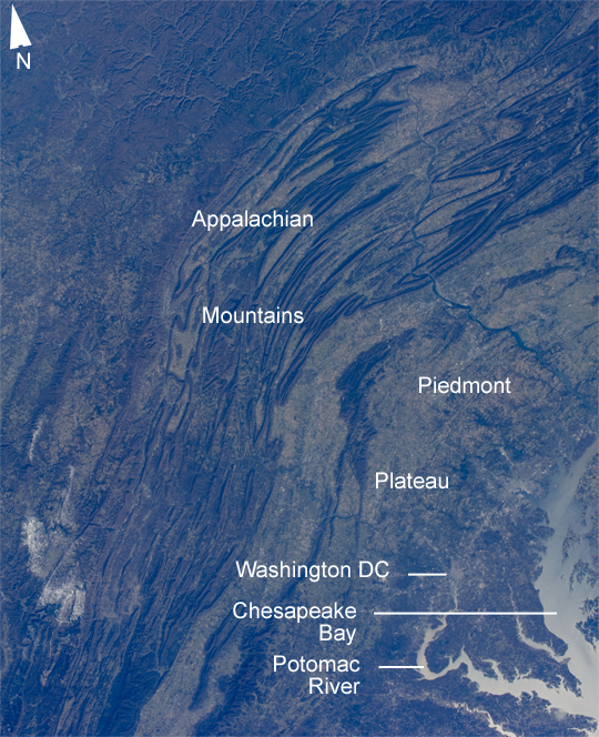
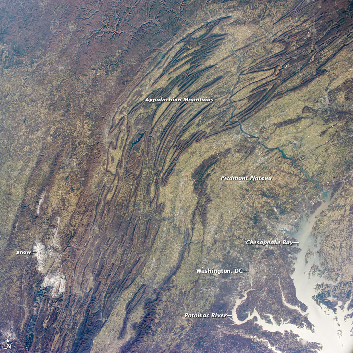
Image Caption: Appalachian Mountains, eastern USA
Note: This caption refers to the image versions labeled "NASA's Earth Observatory web site".
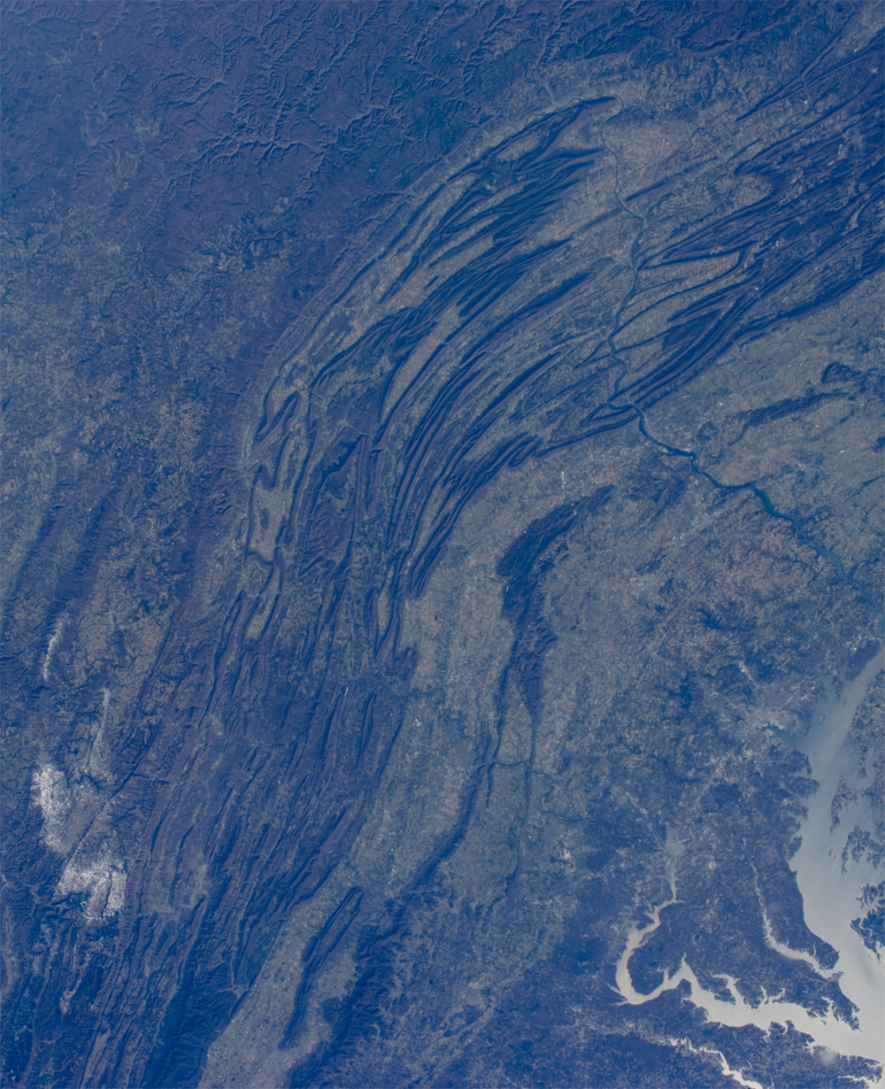
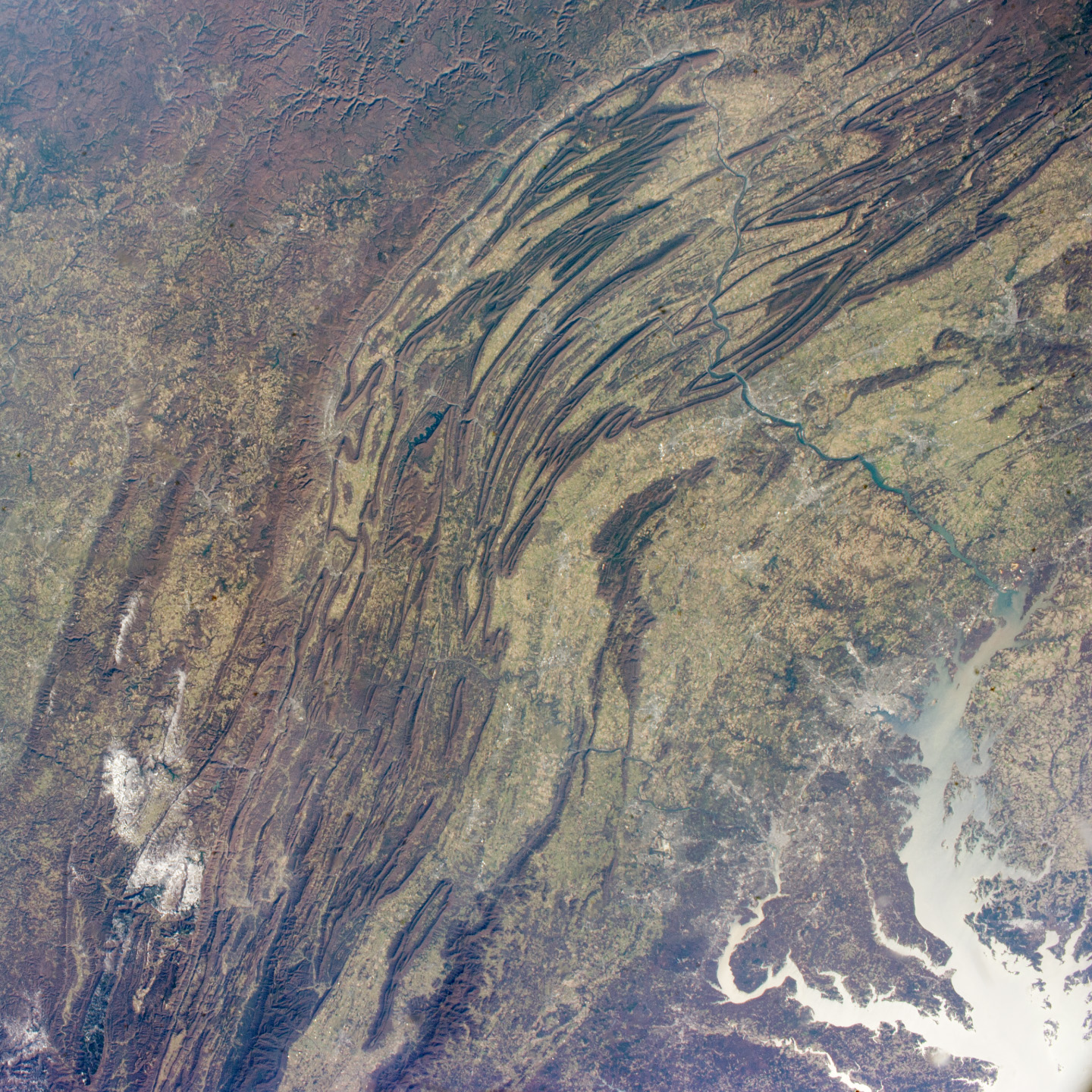
This regional view from the International Space Station shows the striking visual effect of the valley-and-ridge topography of the Appalachian Mountains as viewed from orbit. The view shows more than 300 miles (500 km) of this low mountain chain, from northeast Pennsylvania (image top right) to southern West Virginia, where a dusting of snow can be seen (image lower left). Sunglint reflections reveal detail of Chesapeake Bay and the great bend of the Potomac River. Cities are difficult to detect from space during daylight hours, so the sickle-shaped bend of the river is a good visual guide for astronauts trying to photograph the nation's capital, Washington D.C. (image lower right). The farm-dominated Piedmont Plateau is the light-toned area between the mountains and the bay.
The Appalachian Mts. appear striped because the ridges are forested, providing a dense and dark canopy cover, while the valleys are farmed with crops that generally appear as lighter-toned areas. Geologically the valleys are the softer, more erodible rock layers, much the preferred places for human settlement. Not only do the larger rivers occupy the valley floors, but all the larger rivers flow in them, soils are thicker, slopes are gentle, and valleys are better protected from winter winds.
Rocks that form the valley-and-ridge province, as it is known, are relatively old (540-300 million years old), and were laid down in horizontal layers when North America was attached to Europe as the ancient supercontinent of Laurasia. During this time Gondwanaland - an ancient supercontinent that included present-day Africa, India, South America, Australia, and Antarctica - was approaching Laurasia under the influence of plate tectonics. The northwest coastline of modern Africa was the section of Gondwanaland that "bumped up" against modern North America over a long period (320 - 260 million years ago).
The net result of the tectonic collision was the building of a major mountain chain, much higher than the present Appalachian range--in the process of which the flat-lying rock layers were crumpled up into a series of tight folds, at right angles to the advance of Gondwanaland. The collision also formed the singular supercontinent of Pangaea. Over the following 200 million years, Pangaea broke apart; the modern Atlantic Ocean formed; and erosion wore down the high mountains. What is left to see 200 million years later are the coastline of North America, and the eroded stumps of the mountain chain as the relatively low, but visually striking present-day Appalachian Mts.
Note: This caption refers to the image versions labeled "NASA's Earth Observatory web site".
This regional view from the International Space Station shows the striking visual effect of the valley-and-ridge topography of the Appalachian Mountains as viewed from orbit. The view shows more than 300 miles (500 km) of this low mountain chain, from northeast Pennsylvania (image top right) to southern West Virginia, where a dusting of snow can be seen (image lower left). Sunglint reflections reveal detail of Chesapeake Bay and the great bend of the Potomac River. Cities are difficult to detect from space during daylight hours, so the sickle-shaped bend of the river is a good visual guide for astronauts trying to photograph the nation's capital, Washington D.C. (image lower right). The farm-dominated Piedmont Plateau is the light-toned area between the mountains and the bay.
The Appalachian Mts. appear striped because the ridges are forested, providing a dense and dark canopy cover, while the valleys are farmed with crops that generally appear as lighter-toned areas. Geologically the valleys are the softer, more erodible rock layers, much the preferred places for human settlement. Not only do the larger rivers occupy the valley floors, but all the larger rivers flow in them, soils are thicker, slopes are gentle, and valleys are better protected from winter winds.
Rocks that form the valley-and-ridge province, as it is known, are relatively old (540-300 million years old), and were laid down in horizontal layers when North America was attached to Europe as the ancient supercontinent of Laurasia. During this time Gondwanaland - an ancient supercontinent that included present-day Africa, India, South America, Australia, and Antarctica - was approaching Laurasia under the influence of plate tectonics. The northwest coastline of modern Africa was the section of Gondwanaland that "bumped up" against modern North America over a long period (320 - 260 million years ago).
The net result of the tectonic collision was the building of a major mountain chain, much higher than the present Appalachian range--in the process of which the flat-lying rock layers were crumpled up into a series of tight folds, at right angles to the advance of Gondwanaland. The collision also formed the singular supercontinent of Pangaea. Over the following 200 million years, Pangaea broke apart; the modern Atlantic Ocean formed; and erosion wore down the high mountains. What is left to see 200 million years later are the coastline of North America, and the eroded stumps of the mountain chain as the relatively low, but visually striking present-day Appalachian Mts.
