ISS033-E-18010
| NASA Photo ID | ISS033-E-18010 |
| Focal Length | 800mm |
| Date taken | 2012.11.03 |
| Time taken | 02:11:24 GMT |
Resolutions offered for this image:
1000 x 573 pixels 540 x 309 pixels 1440 x 960 pixels 720 x 480 pixels 4256 x 2832 pixels 640 x 426 pixels
1000 x 573 pixels 540 x 309 pixels 1440 x 960 pixels 720 x 480 pixels 4256 x 2832 pixels 640 x 426 pixels


Spacecraft nadir point: 51.1° N, 152.8° E
Photo center point: 56.0° N, 160.5° E
Photo center point by machine learning:
Photo center point: 56.0° N, 160.5° E
Photo center point by machine learning:
Nadir to Photo Center: Northeast
Spacecraft Altitude: 225 nautical miles (417km)
Country or Geographic Name: | RUSSIAN FEDERATION |
Features: | KAMEN VOLCANO, TOBALCHIK VOLCANO, USHKOVSKY VOLCANO, BEZYMIANNY VOLCANO, PLUME |
| Features Found Using Machine Learning: | |
Cloud Cover Percentage: | 75 (51-75)% |
Sun Elevation Angle: | 23° |
Sun Azimuth: | 190° |
Camera: | Nikon D3S Electronic Still Camera |
Focal Length: | 800mm |
Camera Tilt: | High Oblique |
Format: | 4256E: 4256 x 2832 pixel CMOS sensor, 36.0mm x 23.9mm, total pixels: 12.87 million, Nikon FX format |
Film Exposure: | |
| Additional Information | |
| Width | Height | Annotated | Cropped | Purpose | Links |
|---|---|---|---|---|---|
| 1000 pixels | 573 pixels | No | Yes | Earth From Space collection | Download Image |
| 540 pixels | 309 pixels | Yes | Yes | Earth From Space collection | Download Image |
| 1440 pixels | 960 pixels | No | Yes | NASA's Earth Observatory web site | Download Image |
| 720 pixels | 480 pixels | Yes | Yes | NASA's Earth Observatory web site | Download Image |
| 4256 pixels | 2832 pixels | No | No | Download Image | |
| 640 pixels | 426 pixels | No | No | Download Image |
Download Packaged File
Download a Google Earth KML for this Image
View photo footprint information
Download a GeoTIFF for this photo
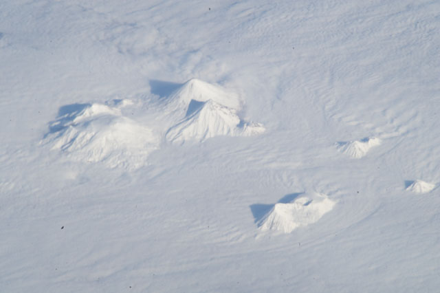
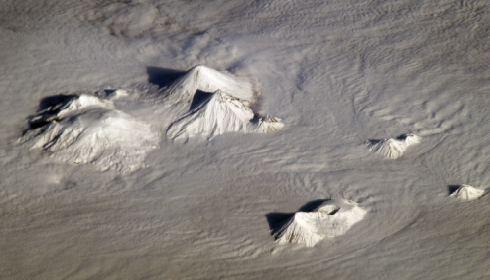
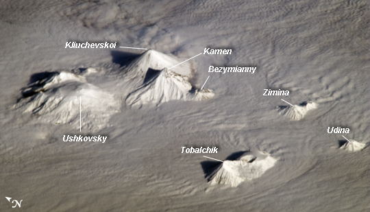
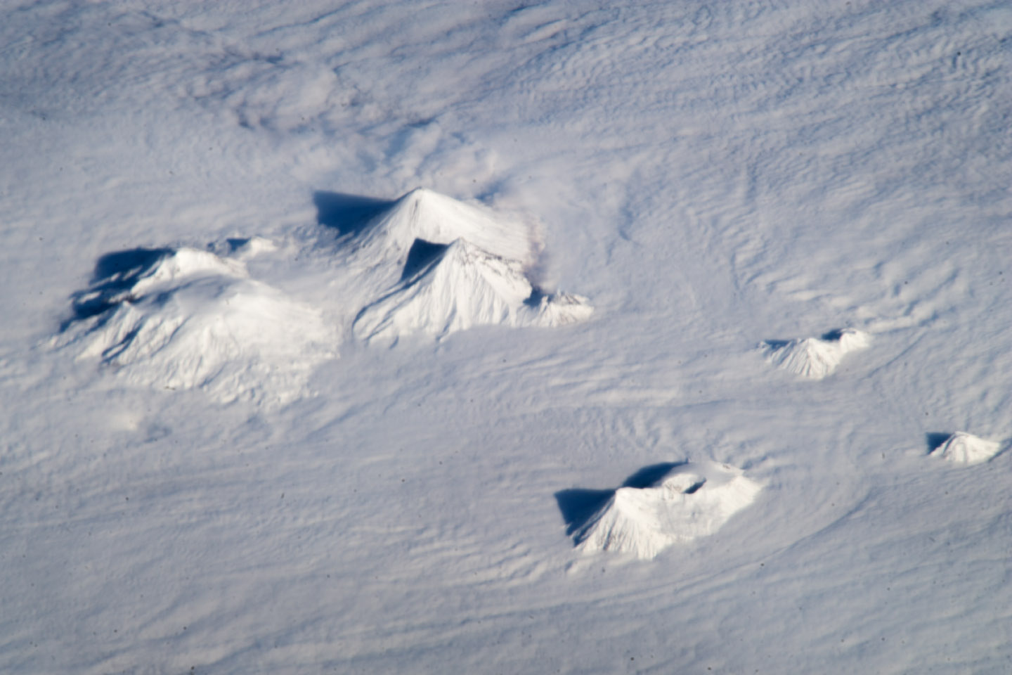
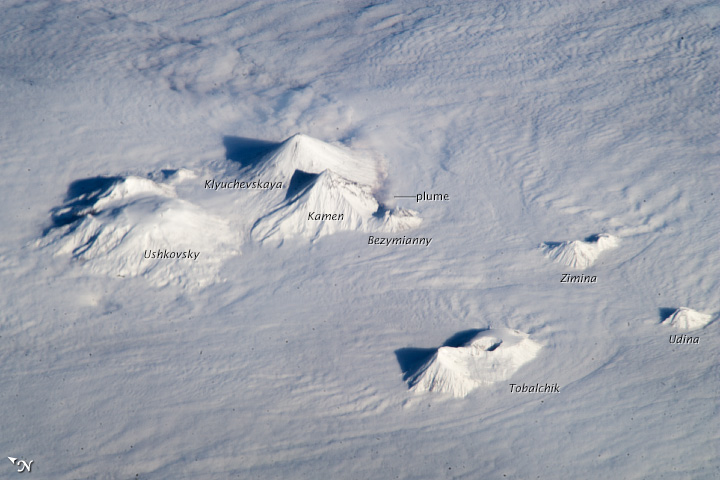
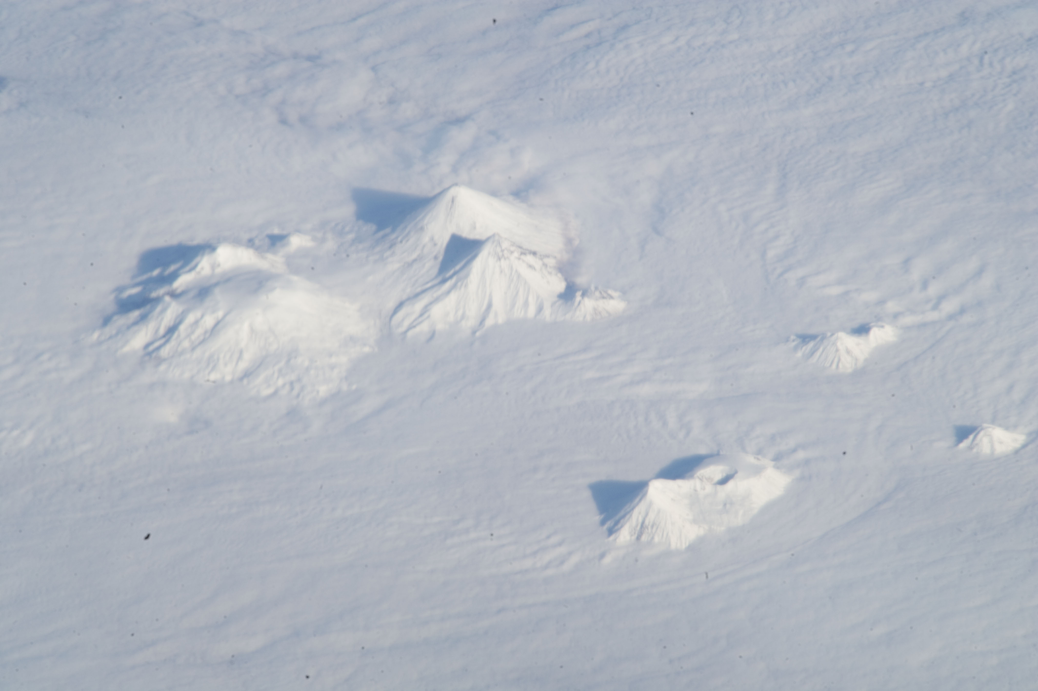
Image Caption: Central Kamchatka Volcanoes, Russian Federation
The snow-covered peaks of several volcanoes of the central Kamchatka Peninsula are visible standing above a fairly uniform cloud deck that obscures the surrounding lowlands. In addition to the rippled cloud patterns caused by interactions of air currents and the volcanoes, a steam and ash plume is visible at image center extending north-northeast from the relatively low summit (2882 meters above sea level, or asl) of Bezymianny volcano. Volcanic activity in this part of Russia is relatively frequent, and well monitored by Russia's Kamchatka Volcanic Eruption Response Team (KVERT).
Directly to the north and northeast of Bezymianny, the much larger and taller stratovolcanoes Kamen (4585 m asl) and Kliuchevskoi (4835 m asl) are visible. Kliuchevskoi, Kamchatka's most active volcano, last erupted in 2011 whereas neighboring Kamen has not erupted during the recorded history of the region. An explosive eruption from the summit of the large volcanic massif of Ushkovsky (3943 m asl; image left) northwest of Bezymianny occurred in 1890; this is the most recent activity at this volcano.
To the south of Bezymianny, the peaks of Zimina (3081 m asl) and Udina volcanoes are just visible above the cloud deck; no historical eruptions are known from either volcanic center. While the large Tobalchik volcano to the southwest (image bottom center) is largely formed from a basaltic shield volcano, its highest peak (3682 m asl) is formed from an older stratovolcano. Tobalchik last erupted in 1976.
While this image may look like it was taken from a passenger jet, in fact it was taken from the considerably higher altitude of low earth orbit from the International Space Station (ISS). At the time the image was taken, the ISS was located approximately 417 kilometers above the southeastern Sea of Okhotsk; projected downwards to the Earth's surface, the ISS was located over 700 kilometers to the southwest of the volcanoes in the image. The combination of low viewing angle from the ISS, shadows, and height and distance from the volcanoes contributes to the appearance of topographic relief visible in the image.
