ISS032-E-10482

| NASA Photo ID | ISS032-E-10482 |
| Focal Length | 180mm |
| Date taken | 2012.07.29 |
| Time taken | 14:38:13 GMT |
Resolutions offered for this image:
1000 x 606 pixels 540 x 327 pixels 1440 x 960 pixels 720 x 480 pixels 4288 x 2848 pixels 640 x 425 pixels
1000 x 606 pixels 540 x 327 pixels 1440 x 960 pixels 720 x 480 pixels 4288 x 2848 pixels 640 x 425 pixels


Cloud masks available for this image:
Spacecraft nadir point: 42.1° N, 122.0° W
Photo center point: 39.3° N, 121.9° W
Photo center point by machine learning:
Photo center point: 39.3° N, 121.9° W
Photo center point by machine learning:
Nadir to Photo Center: South
Spacecraft Altitude: 215 nautical miles (398km)
Country or Geographic Name: | USA-CALIFORNIA |
Features: | SUTTER BUTTES, OROVILLE, COLUSA, WILLIAMS, AGRICULTURAL FIELDS |
| Features Found Using Machine Learning: | |
Cloud Cover Percentage: | 10 (1-10)% |
Sun Elevation Angle: | 17° |
Sun Azimuth: | 80° |
Camera: | Nikon D2Xs Electronic Still Camera |
Focal Length: | 180mm |
Camera Tilt: | 38 degrees |
Format: | 4288E: 4288 x 2848 pixel CMOS sensor, RGBG imager color filter |
Film Exposure: | |
| Additional Information | |
| Width | Height | Annotated | Cropped | Purpose | Links |
|---|---|---|---|---|---|
| 1000 pixels | 606 pixels | No | Yes | Earth From Space collection | Download Image |
| 540 pixels | 327 pixels | Yes | Yes | Earth From Space collection | Download Image |
| 1440 pixels | 960 pixels | No | Yes | NASA's Earth Observatory web site | Download Image |
| 720 pixels | 480 pixels | Yes | Yes | NASA's Earth Observatory web site | Download Image |
| 4288 pixels | 2848 pixels | No | No | Download Image | |
| 640 pixels | 425 pixels | No | No | Download Image |
Download Packaged File
Download a Google Earth KML for this Image
View photo footprint information
Download a GeoTIFF for this photo
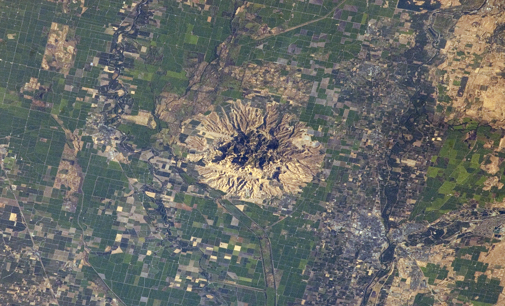
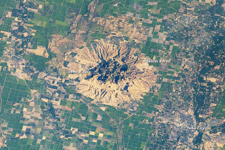
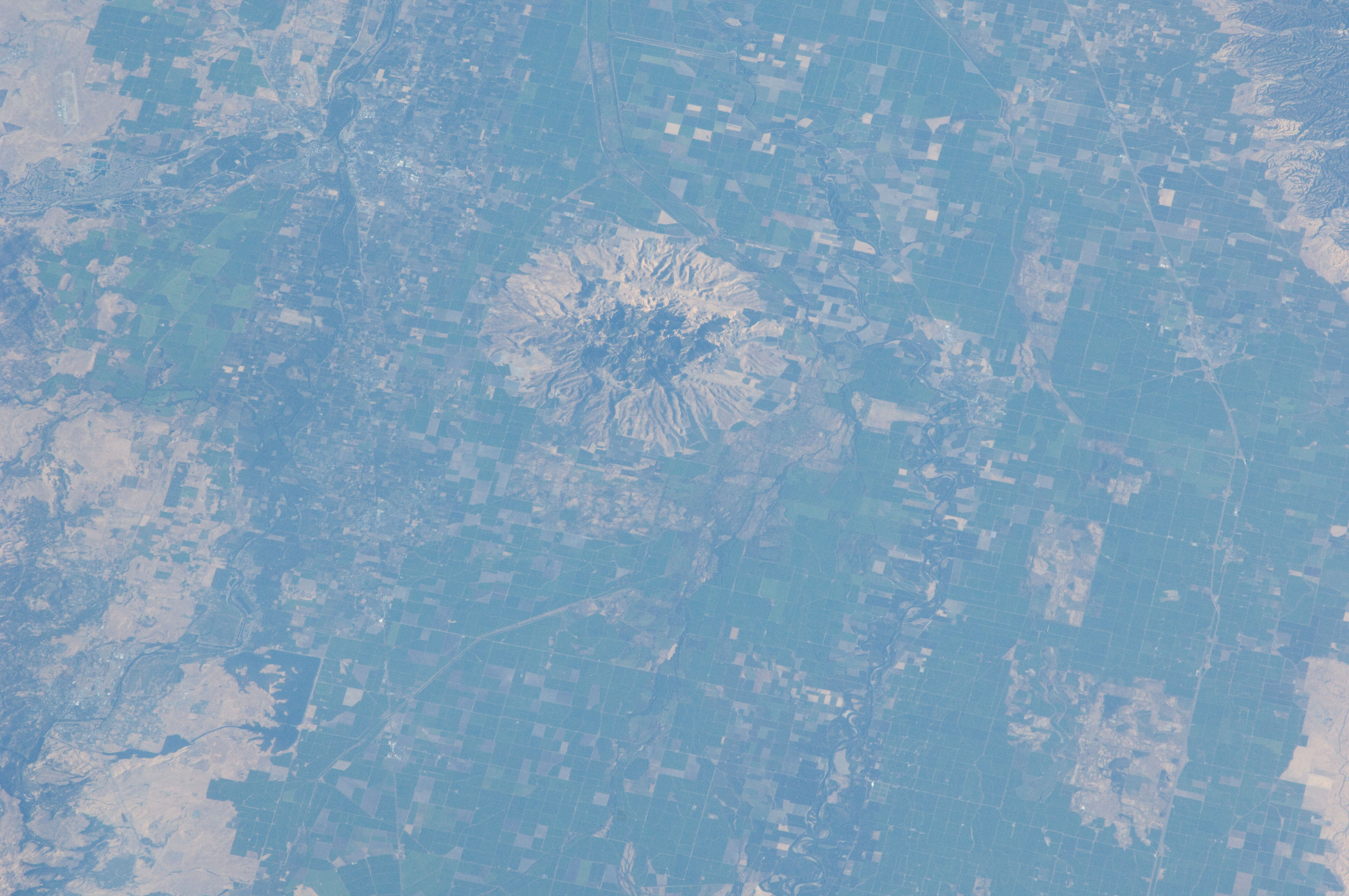
Image Caption: Sutter Buttes, California
Note: This caption refers to the image versions labeled "NASA's Earth Observatory web site".
Sometimes called the "smallest mountain range in the world", the Sutter Buttes rise almost 610 meters above the surrounding flat agricultural fields of the Great Valley of central California. The Sutter Buttes are remnants of a volcano that was active approximately 1.6 - 1.4 million years ago during the Pleistocene Epoch. The central core of the Buttes is characterized by lava domes -piles of viscous lava that erupted onto the surface, building higher with each successive layer. Today, these lava domes form the high central hills of the Buttes; shadows cast by the hills are visible at image center.
Surrounding the central core is an apron of fragmental material created by occasional eruptions of the lava domes - this apron extends roughly 18 km east-west and 16 km north-south. The volcanic material was transported outwards from the central core during eruptions by hot gasses (pyroclastic flows) or by cooler water-driven flows (lahars). Later stream erosion of the debris apron is evident from the radial drainage pattern surrounding the central core. A third geomorphic region of valleys known as the "moat" is present between the core and the debris apron, and was formed from erosion of older, exposed sedimentary rocks that underlie the volcanic rocks.
The Sutter Buttes present a striking visual contrast with the surrounding green agricultural fields--here mostly rice, with some sunflower, winter wheat, tomato, and almonds--of the Great Valley. Urban areas such as Yuba City, CA (located 18 km to the southeast) appear as light to dark gray stippled regions. Sacramento, CA (not shown) is located approximately 80 km to the south-southeast. The image appears slightly distorted (oblique) due to the viewing angle from the International Space Station.
