ISS031-E-30896
| NASA Photo ID | ISS031-E-30896 |
| Focal Length | 180mm |
| Date taken | 2012.05.11 |
| Time taken | 05:06:38 GMT |
Resolutions offered for this image:
1000 x 664 pixels 540 x 359 pixels 720 x 480 pixels 4288 x 2848 pixels 640 x 425 pixels
1000 x 664 pixels 540 x 359 pixels 720 x 480 pixels 4288 x 2848 pixels 640 x 425 pixels


Cloud masks available for this image:
Spacecraft nadir point: 46.4° N, 56.9° E
Photo center point: 44.9° N, 53.7° E
Photo center point by machine learning:
Photo center point: 44.9° N, 53.7° E
Photo center point by machine learning:
Nadir to Photo Center: West
Spacecraft Altitude: 214 nautical miles (396km)
Country or Geographic Name: | KAZAKHSTAN |
Features: | SOR KAYDAK MARSH, OIL WELLS, PIPELINE |
| Features Found Using Machine Learning: | |
Cloud Cover Percentage: | 10 (1-10)% |
Sun Elevation Angle: | 43° |
Sun Azimuth: | 112° |
Camera: | Nikon D2Xs Electronic Still Camera |
Focal Length: | 180mm |
Camera Tilt: | 45 degrees |
Format: | 4288E: 4288 x 2848 pixel CMOS sensor, RGBG imager color filter |
Film Exposure: | |
| Additional Information | |
| Width | Height | Annotated | Cropped | Purpose | Links |
|---|---|---|---|---|---|
| 1000 pixels | 664 pixels | No | Yes | Earth From Space collection | Download Image |
| 540 pixels | 359 pixels | Yes | Yes | Earth From Space collection | Download Image |
| 720 pixels | 480 pixels | Yes | No | NASA's Earth Observatory web site | Download Image |
| 4288 pixels | 2848 pixels | No | No | Download Image | |
| 640 pixels | 425 pixels | No | No | Download Image |
Download Packaged File
Download a Google Earth KML for this Image
View photo footprint information
Download a GeoTIFF for this photo
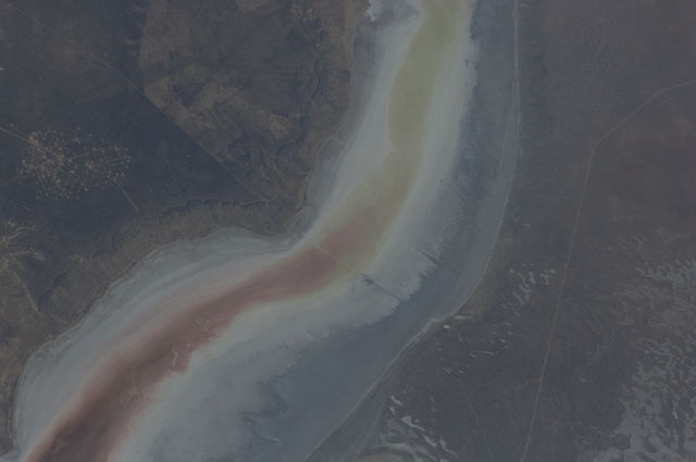
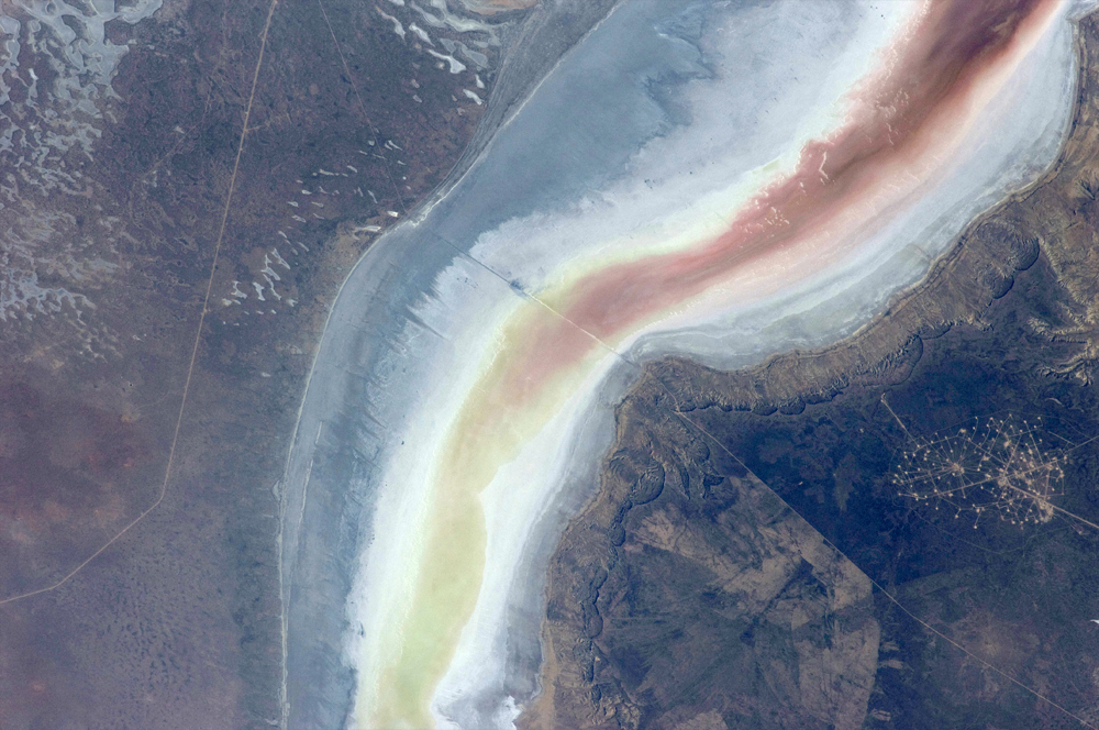
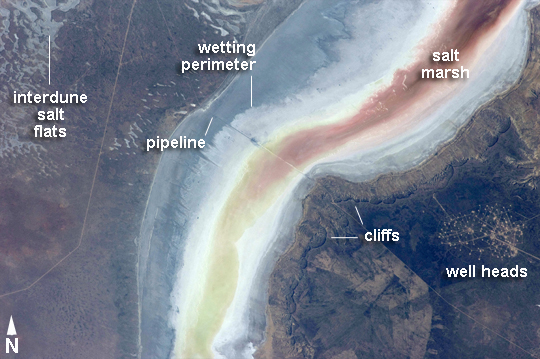
Image Caption: Sor Kaydak, NE Caspian Sea, Kazakhstan
Note: This caption refers to the image versions labeled "NASA's Earth Observatory web site".
This striking image shows saline water of different colors in the Sor Kaydak, a salt marsh that leads into the northeast bulb of the Caspian Sea. The central 50 km of this 180 km-long depression is shown in this astronaut photograph. The Sor Kaydak depression is inundated on occasion by water from the Caspian Sea since it lies at the same elevation--that is, 29 m below global sea level--though separated from the Sea by a low bar of land that is 1-2 m high.
The different colors of marsh water (brown to pink to light green, northeast to southwest) result from the interplay of water depth and resident organisms such as algae. Algae color varies depending on water temperature and salinity. The irregular gray areas at image top left are wet zones between low sand dunes. These interdune flats are whitened with salt derived by evaporation of Caspian Sea water (the sea is just outside the image top left). The jagged line following the colored water (crossing the center of the image top to bottom) is the limit of the wetting zone (or perimeter), an irregular zone influenced by wind and the depth of water in the marsh.
Small cliffs can be seen marking the east margin of the depression that contains Sor Kaydak. Above the cliffs a plateau surface (~200 m above the salt marsh, ~160 m above global sea level) extends eastward for hundreds of km. Here the plateau is occupied by a dense pattern of well heads which appear as a geometric pattern of tan dots. By contrast, the west margin (image left) rises less than 10 m above the marsh altitude. The straight line visible at image center is a pipeline built across the salt marsh which takes oil to a terminal on the Caspian shore 100 km northwest of the area shown here.
