ISS030-E-59398
| NASA Photo ID | ISS030-E-59398 |
| Focal Length | 180mm |
| Date taken | 2012.01.19 |
| Time taken | 12:19:55 GMT |
Resolutions offered for this image:
1000 x 664 pixels 540 x 359 pixels 720 x 480 pixels 4288 x 2848 pixels 640 x 425 pixels
1000 x 664 pixels 540 x 359 pixels 720 x 480 pixels 4288 x 2848 pixels 640 x 425 pixels
Cloud masks available for this image:
Spacecraft nadir point: 13.8° N, 18.5° E
Photo center point: 12.8° N, 17.5° E
Photo center point by machine learning:
Photo center point: 12.8° N, 17.5° E
Photo center point by machine learning:
Nadir to Photo Center: Southwest
Spacecraft Altitude: 216 nautical miles (400km)
Country or Geographic Name: | CHAD |
Features: | LAKE FITRI, DUNES, NGELO, NESSABA |
| Features Found Using Machine Learning: | |
Cloud Cover Percentage: | 10 (1-10)% |
Sun Elevation Angle: | 50° |
Sun Azimuth: | 211° |
Camera: | Nikon D2Xs Electronic Still Camera |
Focal Length: | 180mm |
Camera Tilt: | 21 degrees |
Format: | 4288E: 4288 x 2848 pixel CMOS sensor, RGBG imager color filter |
Film Exposure: | |
| Additional Information | |
| Width | Height | Annotated | Cropped | Purpose | Links |
|---|---|---|---|---|---|
| 1000 pixels | 664 pixels | No | Yes | Earth From Space collection | Download Image |
| 540 pixels | 359 pixels | Yes | Yes | Earth From Space collection | Download Image |
| 720 pixels | 480 pixels | Yes | No | NASA's Earth Observatory web site | Download Image |
| 4288 pixels | 2848 pixels | No | No | Download Image | |
| 640 pixels | 425 pixels | No | No | Download Image |
Download Packaged File
Download a Google Earth KML for this Image
View photo footprint information
Download a GeoTIFF for this photo
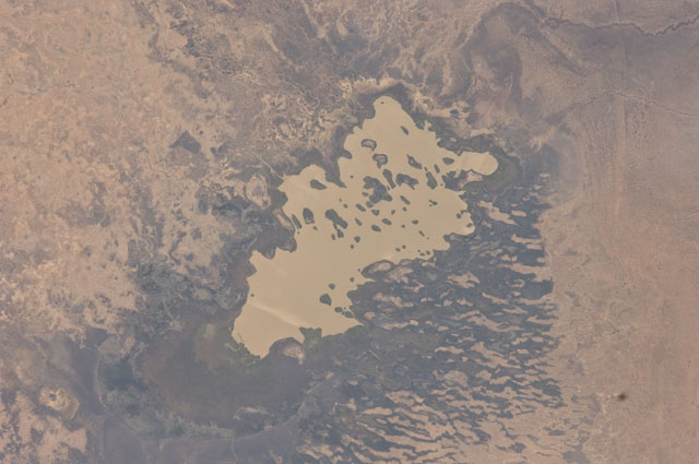
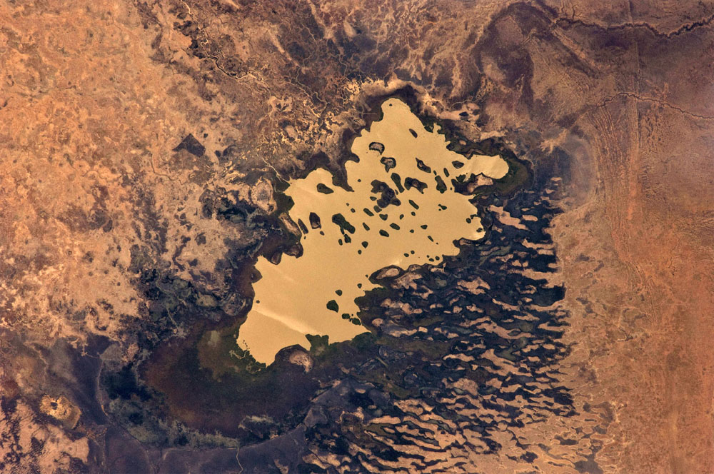
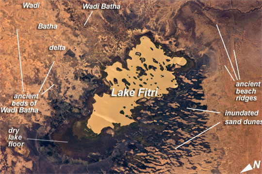
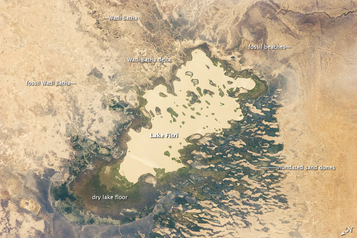
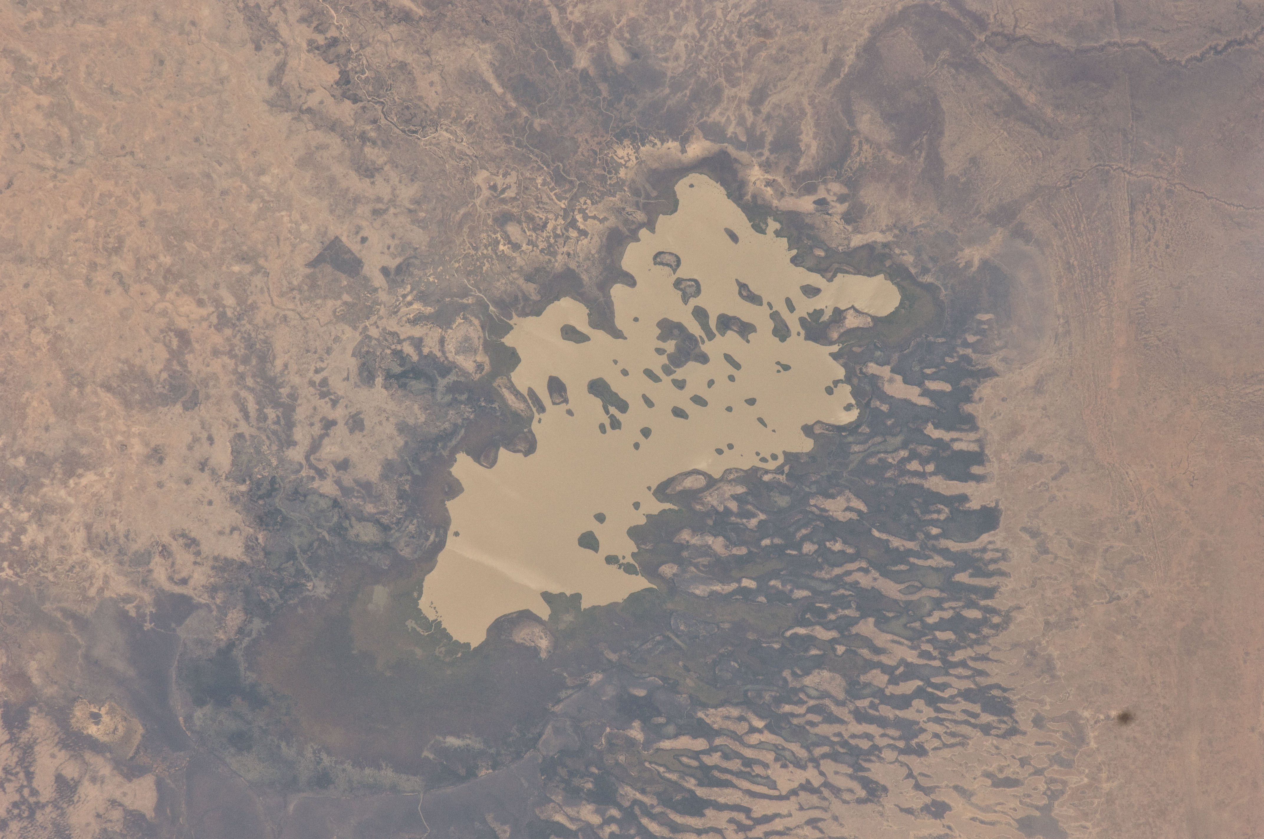
Image Caption: Lake Fitri, Chad
Lake Fitri is an endorheic, or terminal lake in a desert basin in the southern Sahara Desert. Muddy yellow-brown water marks the center of the depression (image center), with a ring of dark brown muds and burnt vegetation on the exposed lake floor to the north. The lake shoreline supports a thin line of reed and floating grass vegetation which appears as dark green in the image. Deserts have so little rainfall that many rivers cannot reach the sea, but end at local low points where they form lakes. Here the usually dry Wadi Batha empties into Lake Fitri. Over time, water flow in Wadi Batha has created a large delta, which occupies the entire top left third of the image--a sense of scale is given by the 23-km length of the lake. The lake has been designated under the Ramsar Convention as a wetland of international importance.
Other features visible in the image reveal evidence of significant climate change. The dry part of the present lake shows that the lake has been larger in the last several decades. But the lake was once many times larger than its present surface area, as shown by numerous sweeping curves of ancient beaches which are now situated many kilometers from the present shoreline, at higher altitudes (image upper right). Inland lakes are highly sensitive to the exact equilibrium between the amount of inflow from contributing rivers like Wadi Batha and evaporation. Each beach ridge therefore shows a different lake level and thus a different balance in the lake-river-climate system. A smaller river enters from the south (top right) and cuts through the beach reaches on its way to the lake.
The irregular, elongated, tan patches to the west of the lake are linear dunes aligned parallel to the dominant winds which blow from the northeast. The dunes have all formed on the downwind side (southwest) side of the lake since the lake bed and delta provide the sands which have built the dunes. The dunes indicate that during past climatic phases the lake has been almost or completely dry on repeated occasions--often enough for these great dunes, many kilometers long and several meters high, to form even in the lowest parts of the lake. The islands visible in the center of the lake are likewise remnants of dunes. These dunes are smaller than those on the lake margin, presumably because waves from the lake have eroded them. Villages occupy the points of some major dunes, and some islands, where fishermen can gain easy access to the lake.
