ISS030-E-30265
| NASA Photo ID | ISS030-E-30265 |
| Focal Length | 70mm |
| Date taken | 2011.12.31 |
| Time taken | 11:59:22 GMT |
Resolutions offered for this image:
1000 x 688 pixels 540 x 372 pixels 720 x 480 pixels 4288 x 2848 pixels 640 x 425 pixels
1000 x 688 pixels 540 x 372 pixels 720 x 480 pixels 4288 x 2848 pixels 640 x 425 pixels


Cloud masks available for this image:
Spacecraft nadir point: 41.4° S, 75.0° W
Photo center point: 36.5° S, 69.0° W
Photo center point by machine learning:
Photo center point: 36.5° S, 69.0° W
Photo center point by machine learning:
Nadir to Photo Center: Northeast
Spacecraft Altitude: 211 nautical miles (391km)
Country or Geographic Name: | ARGENTINA |
Features: | PAYUN MATRU VOLCANO, LAVA FLOWS, SANTA MARIA VOLCANO |
| Features Found Using Machine Learning: | |
Cloud Cover Percentage: | 10 (1-10)% |
Sun Elevation Angle: | 25° |
Sun Azimuth: | 99° |
Camera: | Nikon D2Xs Electronic Still Camera |
Focal Length: | 70mm |
Camera Tilt: | High Oblique |
Format: | 4288E: 4288 x 2848 pixel CMOS sensor, RGBG imager color filter |
Film Exposure: | |
| Additional Information | |
| Width | Height | Annotated | Cropped | Purpose | Links |
|---|---|---|---|---|---|
| 1000 pixels | 688 pixels | No | Yes | Earth From Space collection | Download Image |
| 540 pixels | 372 pixels | Yes | Yes | Earth From Space collection | Download Image |
| 720 pixels | 480 pixels | Yes | Yes | NASA's Earth Observatory web site | Download Image |
| 4288 pixels | 2848 pixels | No | No | Download Image | |
| 640 pixels | 425 pixels | No | No | Download Image |
Download Packaged File
Download a Google Earth KML for this Image
View photo footprint information
Download a GeoTIFF for this photo
Image Caption:
Note: This caption refers to the image versions labeled "NASA's Earth Observatory web site".
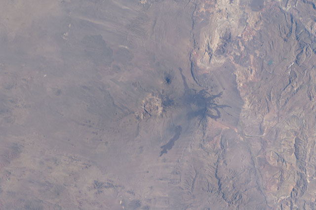
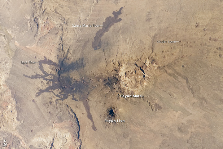
The Payun Matru (3680 m asl) and Payun Liso (3715 meters asl) stratovolcanoes are the highest points of the Payun Matru Volcanic Field located in west-central Argentina, approximately 140 kilometers to the east of the Andes mountain chain. This astronaut photograph from the International Space Station illustrates some of the striking geological features of the field visible from space. The summit of Payun Matru is dominated by a roughly 15 kilometer in diameter caldera (image center), formed by an explosive eruption sometime after approximately 168,000 years ago.
Several dark lava flows, erupted from smaller vents and fissures, are visible in the northwestern part of the volcanic field. One distinct flow, erupted from Volcan Santa Maria located to the northwest of Payun Matru, is approximately 15 kilometers long. A number of small cinder cones, appearing as brown dots due to the short lens used, are built on older lava flows (grey) to the northeast of Payun Matru. While there is no recorded historical observation of the most recent volcanic activity in the field, oral histories suggest that activity was witnessed by indigenous peoples.
Most Andean volcanoes--and earthquakes--follow the trend of the greater Andes chain of mountains, and are aligned roughly N-S above the tectonic boundary between the subducting (descending) Nazca Plate and the overriding South American Plate as is predicted from plate tectonic theory. Other major volcanic centers located some distance away from the major trend typically result from more complex geological processes associated with the subduction zone, and can provide additional insight into the subduction process.
Note: This caption refers to the image versions labeled "NASA's Earth Observatory web site".
The Payun Matru (3680 m asl) and Payun Liso (3715 meters asl) stratovolcanoes are the highest points of the Payun Matru Volcanic Field located in west-central Argentina, approximately 140 kilometers to the east of the Andes mountain chain. This astronaut photograph from the International Space Station illustrates some of the striking geological features of the field visible from space. The summit of Payun Matru is dominated by a roughly 15 kilometer in diameter caldera (image center), formed by an explosive eruption sometime after approximately 168,000 years ago.
Several dark lava flows, erupted from smaller vents and fissures, are visible in the northwestern part of the volcanic field. One distinct flow, erupted from Volcan Santa Maria located to the northwest of Payun Matru, is approximately 15 kilometers long. A number of small cinder cones, appearing as brown dots due to the short lens used, are built on older lava flows (grey) to the northeast of Payun Matru. While there is no recorded historical observation of the most recent volcanic activity in the field, oral histories suggest that activity was witnessed by indigenous peoples.
Most Andean volcanoes--and earthquakes--follow the trend of the greater Andes chain of mountains, and are aligned roughly N-S above the tectonic boundary between the subducting (descending) Nazca Plate and the overriding South American Plate as is predicted from plate tectonic theory. Other major volcanic centers located some distance away from the major trend typically result from more complex geological processes associated with the subduction zone, and can provide additional insight into the subduction process.
