ISS029-E-12564

| NASA Photo ID | ISS029-E-12564 |
| Focal Length | 20mm |
| Date taken | 2011.09.29 |
| Time taken | 08:04:44 GMT |
Resolutions offered for this image:
1000 x 665 pixels 540 x 359 pixels 720 x 480 pixels 4256 x 2832 pixels 640 x 426 pixels
1000 x 665 pixels 540 x 359 pixels 720 x 480 pixels 4256 x 2832 pixels 640 x 426 pixels


Cloud masks available for this image:
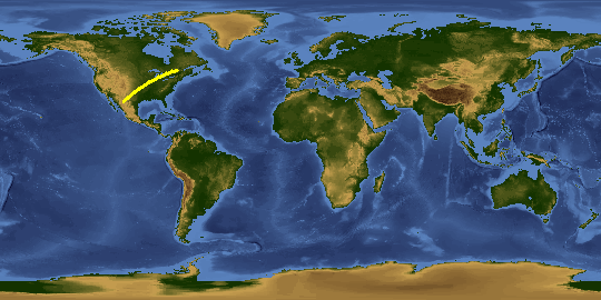
Spacecraft nadir point: 37.4° N, 95.5° W
Photo center point: 41.0° N, 90.5° W
Photo center point by machine learning:
Photo center point: 41.0° N, 90.5° W
Photo center point by machine learning:
Nadir to Photo Center: Northeast
Spacecraft Altitude: 208 nautical miles (385km)
Country or Geographic Name: | USA-ILLINOIS |
Features: | CHICAGO , LAKE MICHIGAN, AURORA BOREALIS, ST LOUIS AT NIGHT |
| Features Found Using Machine Learning: | AURORA, PAN- |
Cloud Cover Percentage: | 10 (1-10)% |
Sun Elevation Angle: | -47° |
Sun Azimuth: | 43° |
Camera: | Nikon D3S Electronic Still Camera |
Focal Length: | 20mm |
Camera Tilt: | High Oblique |
Format: | 4256E: 4256 x 2832 pixel CMOS sensor, 36.0mm x 23.9mm, total pixels: 12.87 million, Nikon FX format |
Film Exposure: | |
| Additional Information | |
This photo is one of the photos used to create this time-lapse video:
| Width | Height | Annotated | Cropped | Purpose | Links |
|---|---|---|---|---|---|
| 1000 pixels | 665 pixels | No | Yes | Earth From Space collection | Download Image |
| 540 pixels | 359 pixels | Yes | Yes | Earth From Space collection | Download Image |
| 720 pixels | 480 pixels | Yes | No | NASA's Earth Observatory web site | Download Image |
| 4256 pixels | 2832 pixels | No | No | Download Image | |
| 640 pixels | 426 pixels | No | No | Download Image |
Download Packaged File
Download a Google Earth KML for this Image
View photo footprint information
Download a GeoTIFF for this photo
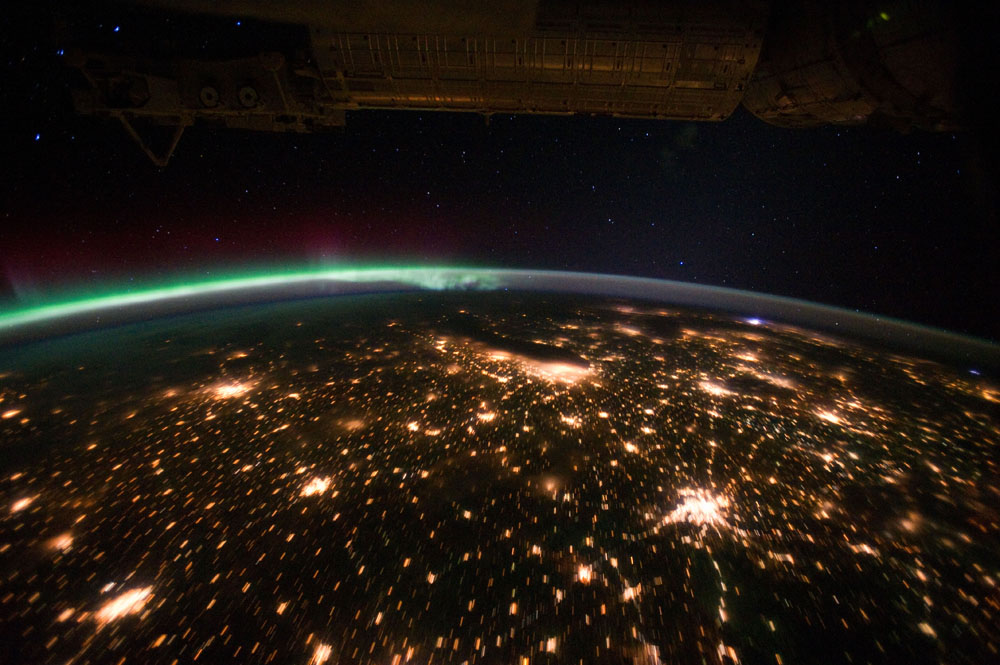
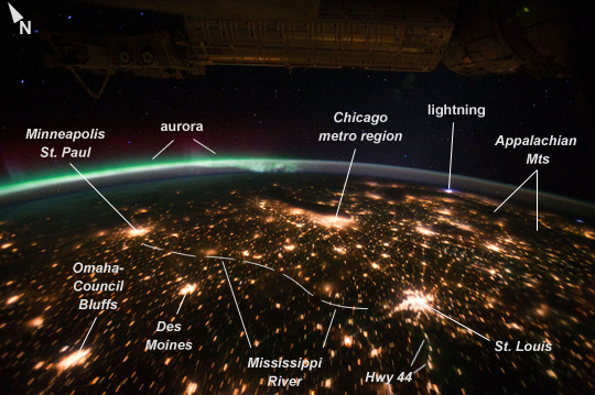
Image Caption: Midwestern USA at Night with Aurora Borealis
The night skies viewed from the International Space Station are illuminated with light from many sources. For example, the Midwestern United States presents a night-time appearance not unlike a patchwork quilt when viewed from orbit. The artificial light from human settlements appears everywhere with a characteristic yellow tinge in this astronaut photograph. But green light of the aurora borealis borealis also appears strongly in this view (image top left)--even seeming to be reflected off the Earth's surface--in Canada--beneath the aurora. A small white patch of light is almost certainly lightning from a storm on the East coast (image top right). Part of the International Space Station appears across the top of the image.
This astronaut photograph highlights the Chicago, IL, metropolitan area as the largest cluster of lights at image center, next to the dark patch of Lake Michigan. The other largest metropolitan areas include St. Louis, MO (lower right), Minneapolis-St. Paul, MN (image left) and the Omaha-Council Bluffs region on the Nebraska-Iowa border (lower left). City light clusters give an immediate sense of relative city size; demographers have used night time satellite imagery to make estimates of city populations, especially in the developing world where city growth can be very rapid.
The US northeast seaboard lies in the most oblique (meaning viewed at an angle) part of the image at top right, just beyond the Appalachian Mts., a dark winding zone without major cities. Scales change significantly in oblique views: Omaha is only 200 km from Des Moines, but appears roughly the same distance from Minneapolis--which is actually 375 km to the north of Des Moines.
In addition to the major metropolitan areas, the rectangular NS/EW-oriented pattern of townships is clearly visible in the rural, lower left part of the image. This pattern instantly gives the sense of north orientation (toward the top left corner) and is a distinctive characteristic of the United States, so that astronauts can quickly know which continent they are flying over even at night.
In contrast to the regular township pattern, interstate highways converge on St. Louis (e.g. Hwy 44), Chicago and other large cities, much like wheel spokes around a central hub. Rivers--major visual features in daylight--become almost invisible at night. The course of the Mississippi River appears as a slightly meandering zone from Minneapolis through St. Louis (dashed line)--the river course continues out of the lower right corner of the image.
