ISS028-E-18675

| NASA Photo ID | ISS028-E-18675 |
| Focal Length | 28mm |
| Date taken | 2011.07.23 |
| Time taken | 13:20:26 GMT |
Resolutions offered for this image:
1000 x 665 pixels 540 x 359 pixels 720 x 480 pixels 4256 x 2832 pixels 640 x 426 pixels
1000 x 665 pixels 540 x 359 pixels 720 x 480 pixels 4256 x 2832 pixels 640 x 426 pixels


Cloud masks available for this image:
Spacecraft nadir point: 25.3° S, 38.4° E
Photo center point: 16.0° S, 33.5° E
Photo center point by machine learning:
Photo center point: 16.0° S, 33.5° E
Photo center point by machine learning:
Nadir to Photo Center: Northwest
Spacecraft Altitude: 214 nautical miles (396km)
Country or Geographic Name: | MOZAMBIQUE |
Features: | PAN-SMOKE PALL, L. KARIBA, L. MALAWI |
| Features Found Using Machine Learning: | PAN- |
Cloud Cover Percentage: | 10 (1-10)% |
Sun Elevation Angle: | 19° |
Sun Azimuth: | 304° |
Camera: | Nikon D3S Electronic Still Camera |
Focal Length: | 28mm |
Camera Tilt: | High Oblique |
Format: | 4256E: 4256 x 2832 pixel CMOS sensor, 36.0mm x 23.9mm, total pixels: 12.87 million, Nikon FX format |
Film Exposure: | |
| Additional Information | |
| Width | Height | Annotated | Cropped | Purpose | Links |
|---|---|---|---|---|---|
| 1000 pixels | 665 pixels | No | Yes | Earth From Space collection | Download Image |
| 540 pixels | 359 pixels | Yes | Yes | Earth From Space collection | Download Image |
| 720 pixels | 480 pixels | Yes | Yes | NASA's Earth Observatory web site | Download Image |
| 4256 pixels | 2832 pixels | No | No | Download Image | |
| 640 pixels | 426 pixels | No | No | Download Image |
Download Packaged File
Download a Google Earth KML for this Image
View photo footprint information
Download a GeoTIFF for this photo
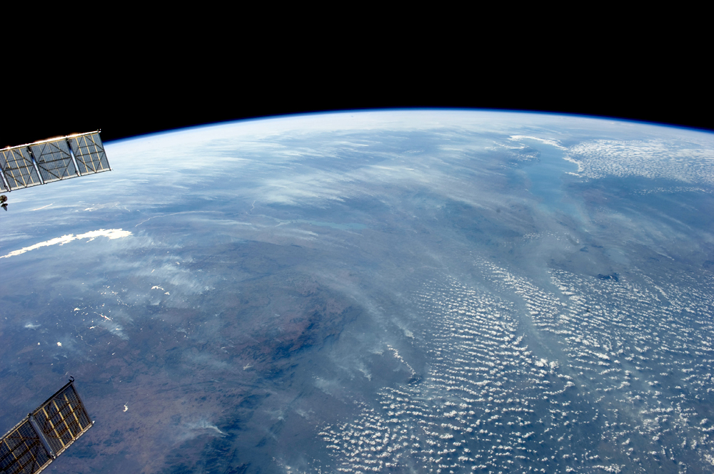
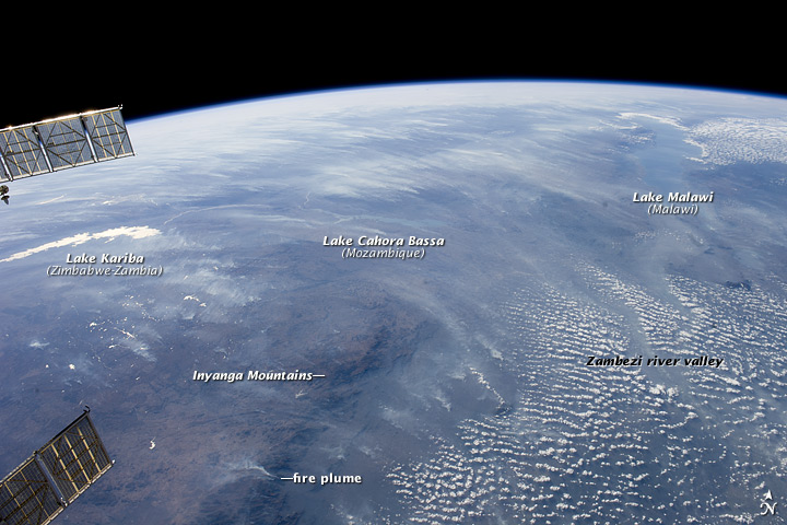
Image Caption: Biomass Burning, Southern Africa
A smoke pall of subcontinental proportions dominates this view of tropical southern Africa. In what has been described as the most fire-prone part of the world, numerous fires give rise to regional smoke palls every dry season. Fires are both natural and set by local people to clear woodland for agricultural fields. This recent, oblique, northwest-looking view taken in July 2011 at the end of the dry season shows the extent of the smoke on the African plateau--from central Zimbabwe (image lower left) to northern Malawi more than 1000 km away (image top right)--and in the wide coastal plains of the lower Zambezi River valley of Mozambique (image lower right). Here smoke can be seen blowing inland (left to right), channeled up the Zambezi River valley and contributing to the pall on the plateau. The light gray smoke plumes contrast with higher altitude, brighter patchy cloud cover at image lower right.
The smoke palls obscure much surface detail, so that Lake Malawi, one of Africa's Great Lakes, is barely visible, as is Lake Cahora Bassa, Africa's fourth largest reservoir, in the Zambezi valley. The sun's reflection off its surface (sunglint) makes Lake Kariba most prominent in the view at image left. Kariba is the world's largest artificial reservoir by volume, and is 220 km long, giving a sense of the scale of the view. The steep, shadowed, mid-afternoon faces of the Inyanga Mountains on the Mozambique-Zimbabwe border protrude above the smoke layer at image lower left. Solar panels extending from Russian spacecraft docked at the International Space Station are visible in the foreground at image left.
