ISS027-E-5274
| NASA Photo ID | ISS027-E-5274 |
| Focal Length | 800mm |
| Date taken | 2011.03.16 |
| Time taken | 04:27:23 GMT |
Resolutions offered for this image:
1000 x 664 pixels 540 x 359 pixels 720 x 480 pixels 4288 x 2929 pixels 640 x 437 pixels
1000 x 664 pixels 540 x 359 pixels 720 x 480 pixels 4288 x 2929 pixels 640 x 437 pixels
Cloud masks available for this image:
Spacecraft nadir point: 40.0° N, 79.0° E
Photo center point: 42.3° N, 80.9° E
Photo center point by machine learning:
Photo center point: 42.3° N, 80.9° E
Photo center point by machine learning:
Nadir to Photo Center: Northeast
Spacecraft Altitude: 184 nautical miles (341km)
Country or Geographic Name: | CHINA |
Features: | TIAN SHAN RANGE, PEAK 6231, XUELIAN FENG, GLACIERS |
| Features Found Using Machine Learning: | |
Cloud Cover Percentage: | 25 (11-25)% |
Sun Elevation Angle: | 37° |
Sun Azimuth: | 132° |
Camera: | Nikon D2Xs Electronic Still Camera |
Focal Length: | 800mm |
Camera Tilt: | 44 degrees |
Format: | 4288E: 4288 x 2848 pixel CMOS sensor, RGBG imager color filter |
Film Exposure: | |
| Additional Information | |
| Width | Height | Annotated | Cropped | Purpose | Links |
|---|---|---|---|---|---|
| 1000 pixels | 664 pixels | No | Yes | Earth From Space collection | Download Image |
| 540 pixels | 359 pixels | Yes | Yes | Earth From Space collection | Download Image |
| 720 pixels | 480 pixels | Yes | Yes | NASA's Earth Observatory web site | Download Image |
| 4288 pixels | 2929 pixels | No | No | Download Image | |
| 640 pixels | 437 pixels | No | No | Download Image |
Download Packaged File
Download a Google Earth KML for this Image
View photo footprint information
Download a GeoTIFF for this photo
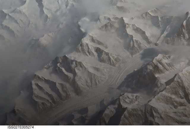
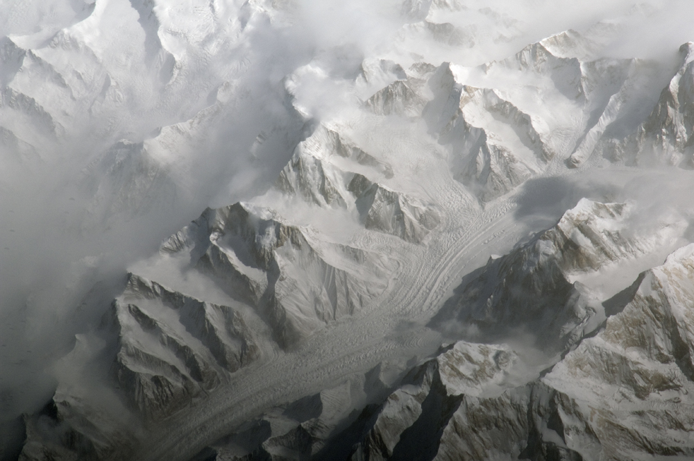
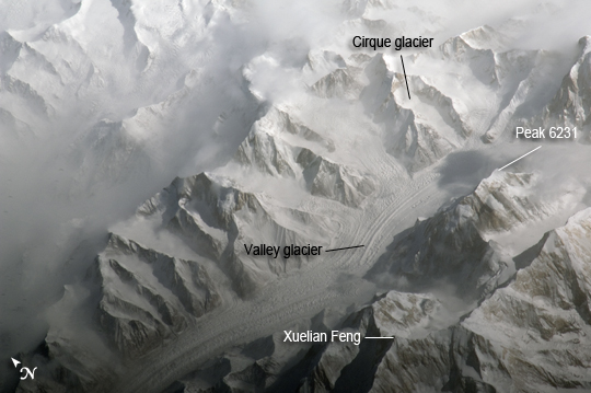
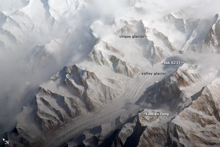
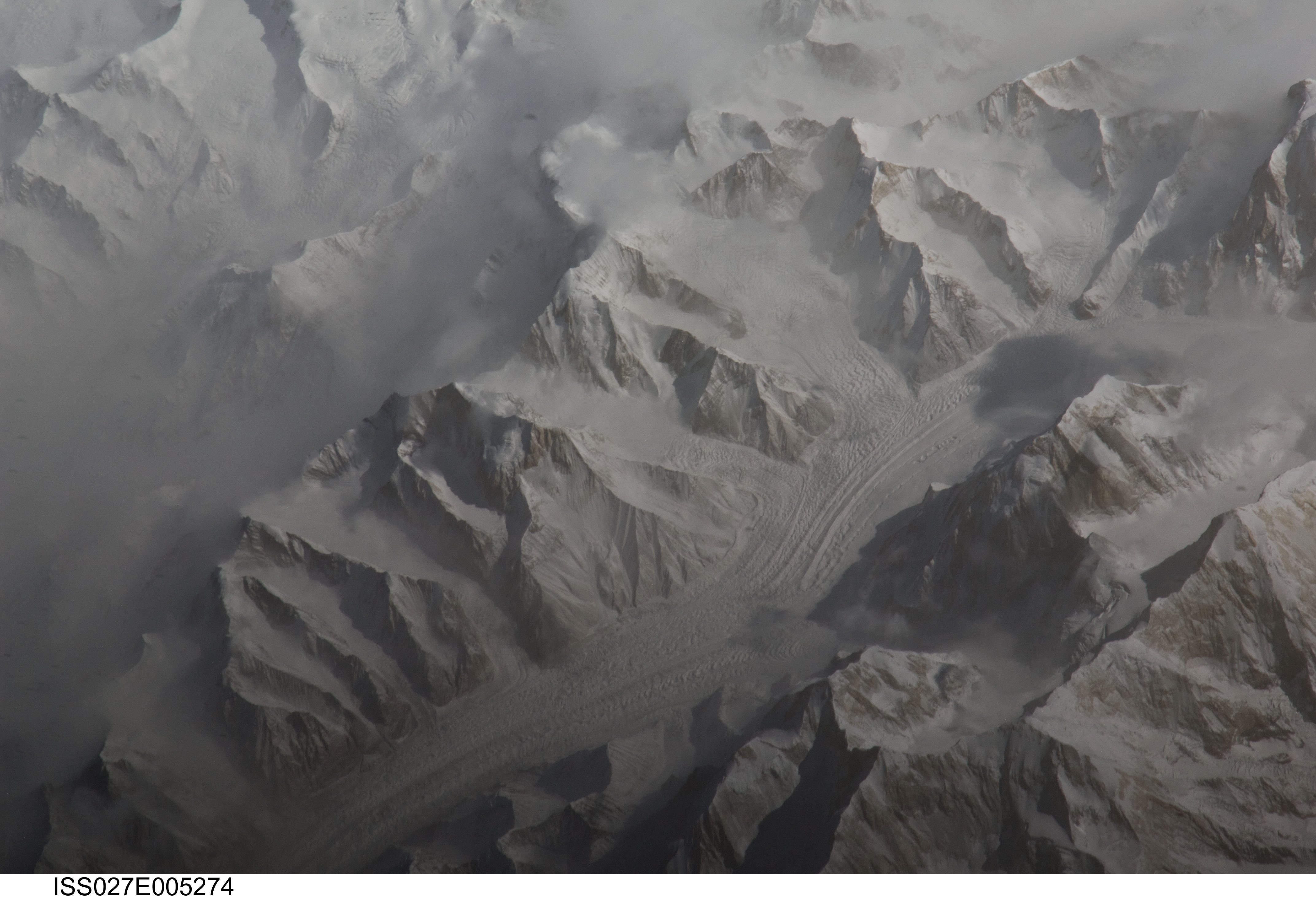
Image Caption: Central Tien Shan, People's Republic of China
The Tien Shan (or "celestial mountains" in Chinese) is one of the largest continuous mountain ranges in the world, extending approximately 2500 kilometers roughly east-west across Central Asia. This astronaut photograph provides a detailed view of part of the central Tien Shan, located approximately 64 kilometers east of where the borders of China, Kyrgyzstan, and Kazakhstan meet. While the image looks like it might have been taken from an airplane, it was taken from the International Space Station (ISS) at an altitude of 341 kilometers. The distance between the ISS ground track position (approximately 304 kilometers to the southwest) and the imaged area produces an oblique - looking outwards an angle, rather than straight down - view that, together with shadowing of valleys, accentuates the mountainous topography.
Like the Himalayas to the south, the uplift of the Tien Shan results from the ongoing collision between the Eurasian and Indian continental tectonic plates. The rugged topography of the range is the result of subsequent erosion by water, wind, and in the highest parts of the range, active glaciers. Two types of glaciers are visible in the image; cirque glaciers occupy amphitheater-like depressions on the upper slopes of the mountains, and feed ice downslope to aggregate into large valley glaciers such as the one visible at image center. Low clouds obscure an adjacent valley and glaciers to the north (image upper left).
Two high peaks of the central Tien Shan are identifiable in the image. Xuelian Feng has a high summit of 6, 527 meters above sea level. To the east, the aptly-named Peak 6231 has summit of 6231 meters above sea level.
