ISS027-E-32535
| NASA Photo ID | ISS027-E-32535 |
| Focal Length | 180mm |
| Date taken | 2011.05.17 |
| Time taken | 13:13:06 GMT |
Resolutions offered for this image:
1000 x 667 pixels 540 x 360 pixels 720 x 480 pixels 4288 x 2929 pixels 640 x 437 pixels
1000 x 667 pixels 540 x 360 pixels 720 x 480 pixels 4288 x 2929 pixels 640 x 437 pixels


Spacecraft nadir point: 28.6° N, 89.8° W
Photo center point: 30.0° N, 90.2° W
Photo center point by machine learning:
Photo center point: 30.0° N, 90.2° W
Photo center point by machine learning:
Nadir to Photo Center: North
Spacecraft Altitude: 184 nautical miles (341km)
Country or Geographic Name: | USA-LOUISIANA |
Features: | MISSISSIPPI RIVER, FLOODING, LAKE PONTCHARTRAIN, NEW ORLEANS |
| Features Found Using Machine Learning: | |
Cloud Cover Percentage: | 10 (1-10)% |
Sun Elevation Angle: | 26° |
Sun Azimuth: | 81° |
Camera: | Nikon D2Xs Electronic Still Camera |
Focal Length: | 180mm |
Camera Tilt: | 25 degrees |
Format: | 4288E: 4288 x 2848 pixel CMOS sensor, RGBG imager color filter |
Film Exposure: | |
| Additional Information | |
| Width | Height | Annotated | Cropped | Purpose | Links |
|---|---|---|---|---|---|
| 1000 pixels | 667 pixels | No | Yes | Earth From Space collection | Download Image |
| 540 pixels | 360 pixels | Yes | Yes | Earth From Space collection | Download Image |
| 720 pixels | 480 pixels | Yes | Yes | NASA's Earth Observatory web site | Download Image |
| 4288 pixels | 2929 pixels | No | No | Download Image | |
| 640 pixels | 437 pixels | No | No | Download Image |
Download Packaged File
Download a Google Earth KML for this Image
View photo footprint information
Download a GeoTIFF for this photo
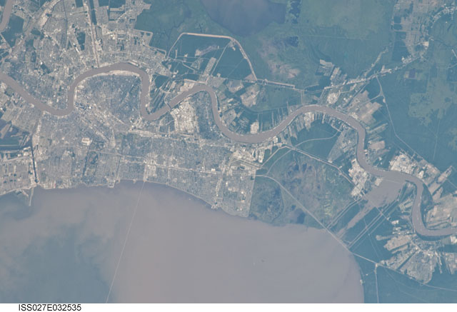
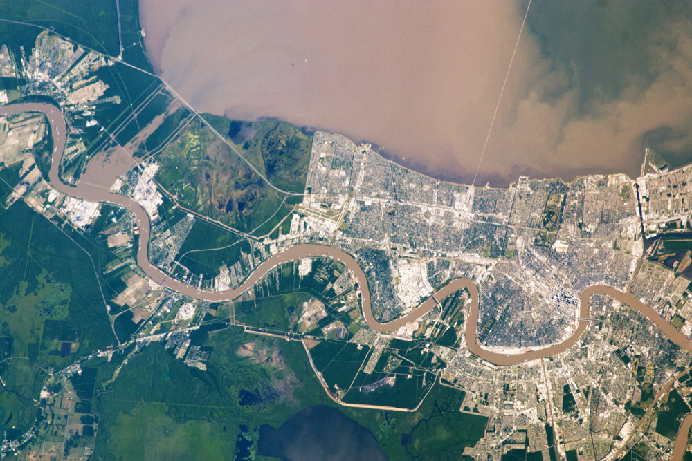
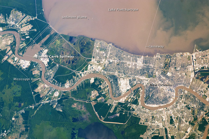
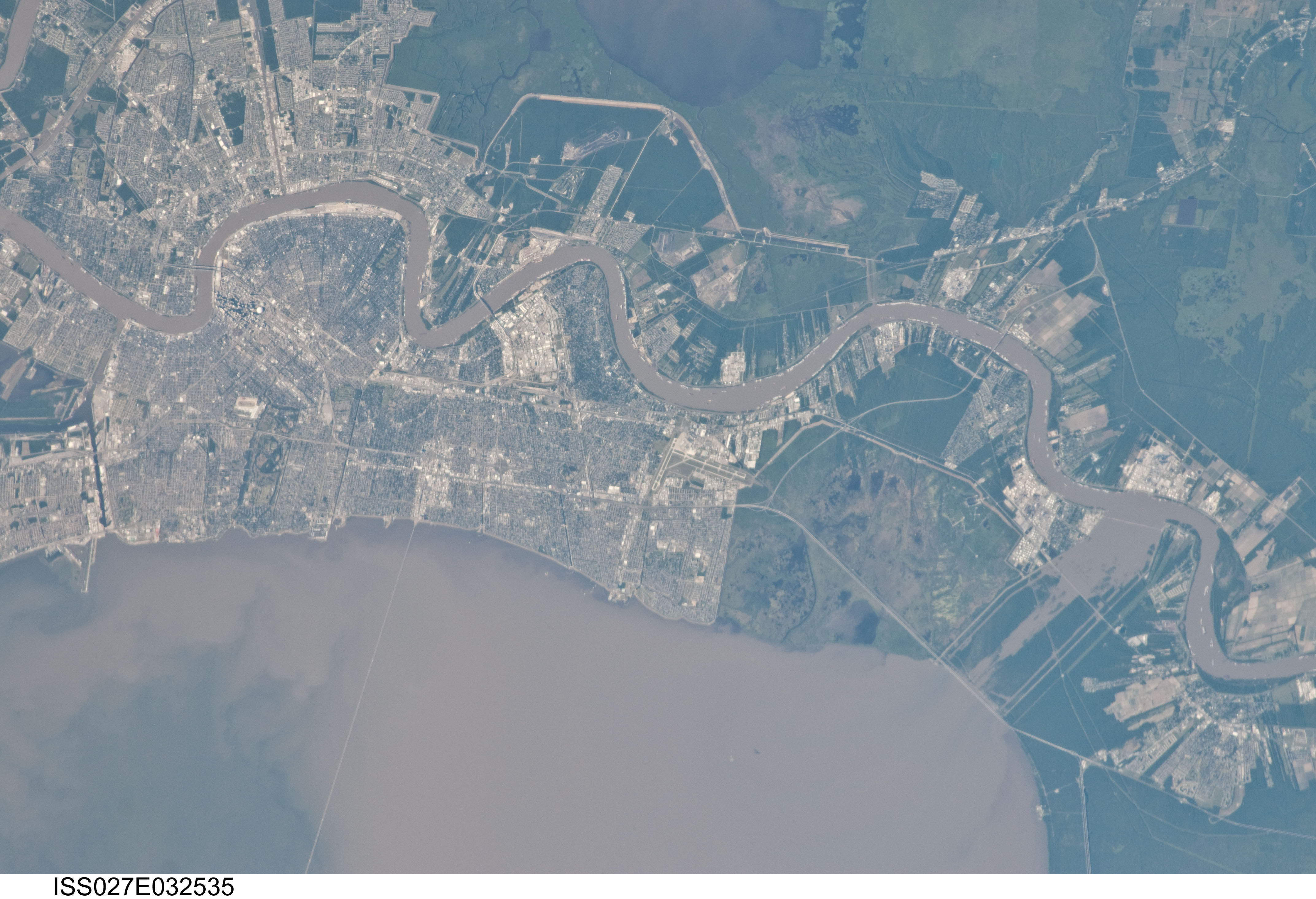
Image Caption: Sediment Plume in Lake Pontchartrain
Note: This caption refers to the image versions labeled "NASA's Earth Observatory web site".
The Bonnet Carre Spillway delivered a plume of thick sediment to Louisiana's Lake Pontchartrain in mid-May 2011. Taken on May 17, 2011, this astronaut photo shows a muddy plume in the lake, as well as the sediment-clogged Mississippi River meandering through the city of New Orleans. Water flowing through the spillway into Lake Pontchartrain is also muddy brown.
The Bonnet Carre Spillway, Morganza Floodway, and breached levee near Cairo, Illinois, all diverted some of the flood waters from the Mississippi River in the spring of 2011. The diversion measures aimed to lessen the damage caused by an unusually severe spring flood season.
The Advanced Hydrological Prediction Service (AHPS) of the U.S. National Weather Service reported that the Mississippi River at New Orleans reached 17.05 feet (5.20 meters) at 9:00 a.m. CDT on May 20, 2011. This was just above the flood stage for this location, of 17.0 feet (5.18 meters), and well below the record flood level of 21.3 feet (6.5 meters), set in 1922. The Mississippi River at Baton Rouge, meanwhile reached 44.71 meters (13.63 feet) at 9:00 a.m. CDT on May 20, the AHPS reported. This qualified as major flooding for the Mississippi at that location, but it was below the record flood level of 47.3 meters (14.4 feet) set in 1927. Mississippi River water levels were projected to remain fairly steady at both locations through May 25, 2011.
