ISS027-E-31908

| NASA Photo ID | ISS027-E-31908 |
| Focal Length | 200mm |
| Date taken | 2011.05.15 |
| Time taken | 23:36:10 GMT |
Resolutions offered for this image:
1000 x 665 pixels 540 x 359 pixels 720 x 480 pixels 4256 x 2913 pixels 640 x 438 pixels
1000 x 665 pixels 540 x 359 pixels 720 x 480 pixels 4256 x 2913 pixels 640 x 438 pixels
Cloud masks available for this image:
Spacecraft nadir point: 27.1° N, 105.1° W
Photo center point: 31.8° N, 109.2° W
Photo center point by machine learning:
Photo center point: 31.8° N, 109.2° W
Photo center point by machine learning:
Nadir to Photo Center: Northwest
Spacecraft Altitude: 185 nautical miles (343km)
Country or Geographic Name: | USA-ARIZONA |
Features: | CHIRICAHUA MOUNTAINS, HORSESHOE 2 FIRE PLUME, WILLCOX PLAYA |
| Features Found Using Machine Learning: | |
Cloud Cover Percentage: | 10 (1-10)% |
Sun Elevation Angle: | 26° |
Sun Azimuth: | 279° |
Camera: | Nikon D3S Electronic Still Camera |
Focal Length: | 200mm |
Camera Tilt: | High Oblique |
Format: | 4256E: 4256 x 2832 pixel CMOS sensor, 36.0mm x 23.9mm, total pixels: 12.87 million, Nikon FX format |
Film Exposure: | |
| Additional Information | |
| Width | Height | Annotated | Cropped | Purpose | Links |
|---|---|---|---|---|---|
| 1000 pixels | 665 pixels | No | Yes | Earth From Space collection | Download Image |
| 540 pixels | 359 pixels | Yes | Yes | Earth From Space collection | Download Image |
| 720 pixels | 480 pixels | Yes | Yes | NASA's Earth Observatory web site | Download Image |
| 4256 pixels | 2913 pixels | No | No | Download Image | |
| 640 pixels | 438 pixels | No | No | Download Image |
Download Packaged File
Download a Google Earth KML for this Image
View photo footprint information
Download a GeoTIFF for this photo
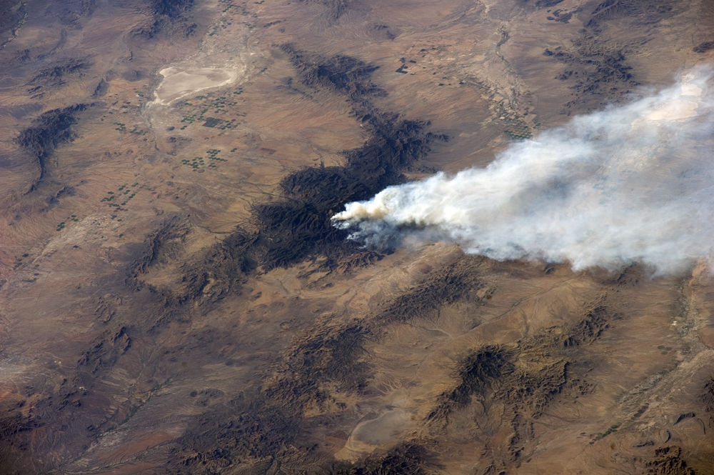
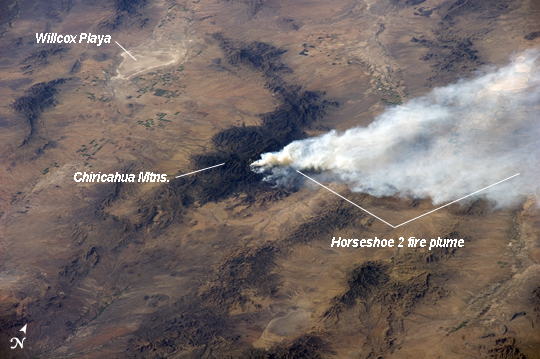
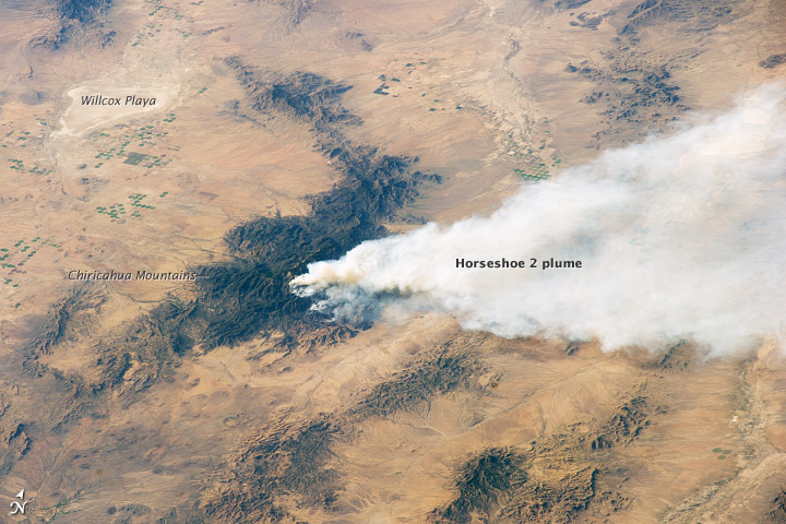
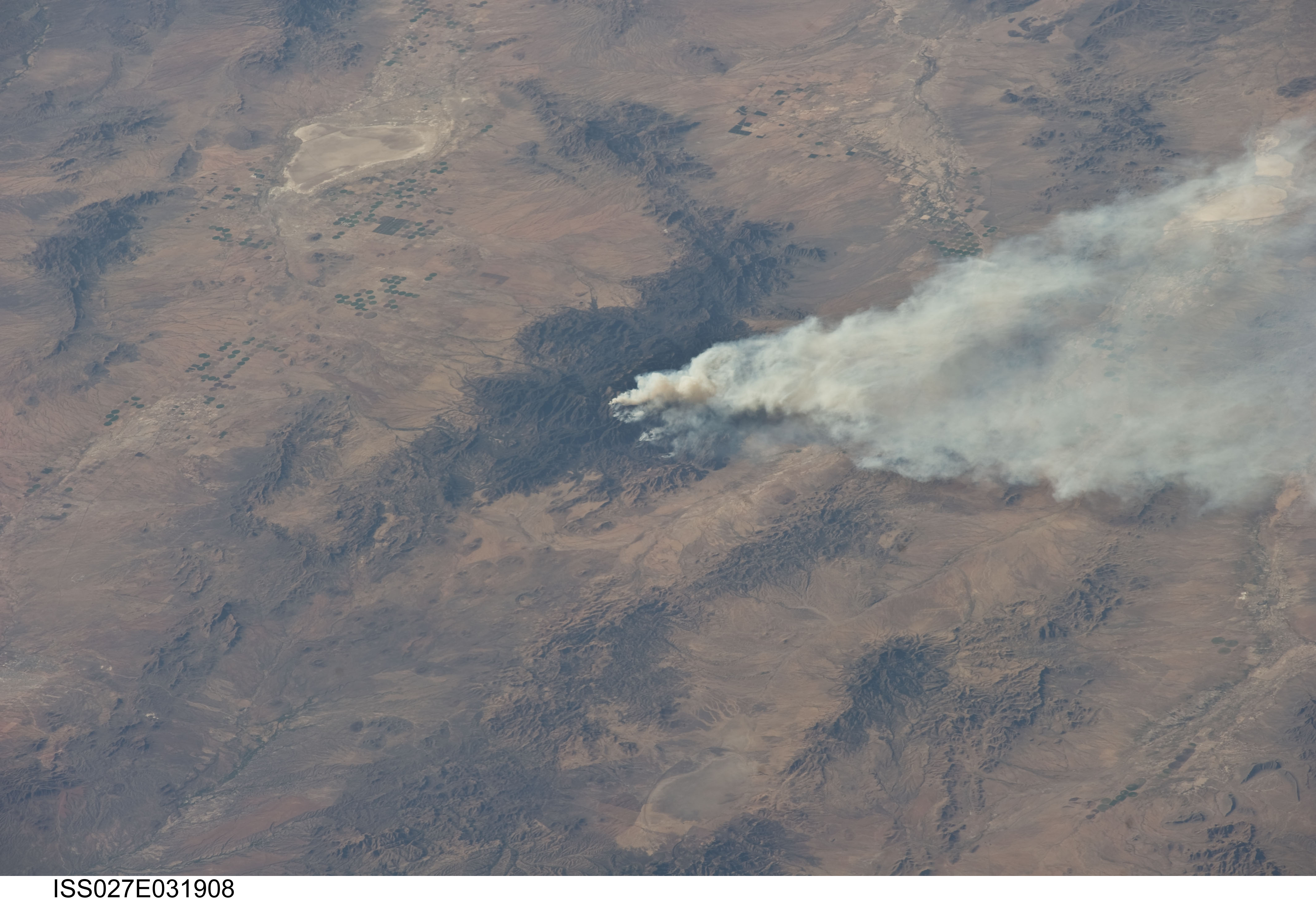
Image Caption: Horseshoe 2 Fire, southeastern Arizona
The Horseshoe 2 fire, located along the southeastern flank of the Chiricahua Mountains in southeastern Arizona, began on May 8, 2011 at approximately 11:00am. The fire is thought to have been started by human activities. This astronaut photograph illustrates the area (approximately 8900 hectares, or 22110 acres) and position of the fire within the mountains on May 15, 2011, as well as an extensive smoke plume extending to the east-northeast over a distance of at least 60 kilometers (approximately 40 miles). As of May 19 2011, the fire had burned an area of nearly 14000 hectares (approximately 34400 acres) of grasses, shrubs, and trees along the mountain slopes.
The Chiricahua Mountains are included within the Chiricahua National Monument located near the borders of Arizona, USA; New Mexico, USA; and Chihuahua, United Mexican States. Elevations in the mountains range from approximately 914 - 3267 meters (300 - 10720 feet) above sea level. The higher elevations--known regionally as "sky islands"--allow for biologically diverse plant and animal communities, adapted to cooler and wetter conditions, to survive while surrounded by semi-arid to arid desert conditions at lower elevations.
The image highlights this contrast in environments; pine and oak forest contributes to the dark coloration of the upper slopes and peaks of the Chiricahuas at image center, while the flat, gray to tan surface of Willcox Playa to the northwest is indicative of the adjacent desert environment.
