ISS027-E-12224
| NASA Photo ID | ISS027-E-12224 |
| Focal Length | 800mm |
| Date taken | 2011.04.09 |
| Time taken | 13:19:41 GMT |
Resolutions offered for this image:
1000 x 677 pixels 540 x 366 pixels 720 x 480 pixels 4256 x 2913 pixels 640 x 438 pixels
1000 x 677 pixels 540 x 366 pixels 720 x 480 pixels 4256 x 2913 pixels 640 x 438 pixels


Cloud masks available for this image:
Spacecraft nadir point: 24.7° S, 43.0° W
Photo center point: 14.5° S, 61.0° W
Photo center point by machine learning:
Photo center point: 14.5° S, 61.0° W
Photo center point by machine learning:
Nadir to Photo Center: Northwest
Spacecraft Altitude: 191 nautical miles (354km)
Country or Geographic Name: | BOLIVIA |
Features: | PAN, TERMINATOR, LIMB, SALAR DE UYUNI, SALAR DE COIPASA |
| Features Found Using Machine Learning: | PAN- |
Cloud Cover Percentage: | 10 (1-10)% |
Sun Elevation Angle: | 51° |
Sun Azimuth: | 38° |
Camera: | Nikon D2Xs Electronic Still Camera |
Focal Length: | 800mm |
Camera Tilt: | High Oblique |
Format: | 4288E: 4288 x 2848 pixel CMOS sensor, RGBG imager color filter |
Film Exposure: | |
| Additional Information | |
| Width | Height | Annotated | Cropped | Purpose | Links |
|---|---|---|---|---|---|
| 1000 pixels | 677 pixels | No | Yes | Earth From Space collection | Download Image |
| 540 pixels | 366 pixels | Yes | Yes | Earth From Space collection | Download Image |
| 720 pixels | 480 pixels | Yes | Yes | NASA's Earth Observatory web site | Download Image |
| 4256 pixels | 2913 pixels | No | No | Download Image | |
| 640 pixels | 438 pixels | No | No | Download Image |
Download Packaged File
Download a Google Earth KML for this Image
View photo footprint information
Download a GeoTIFF for this photo
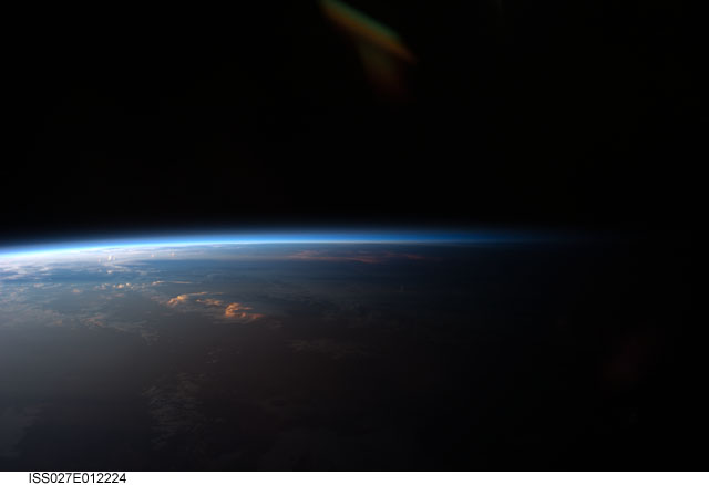
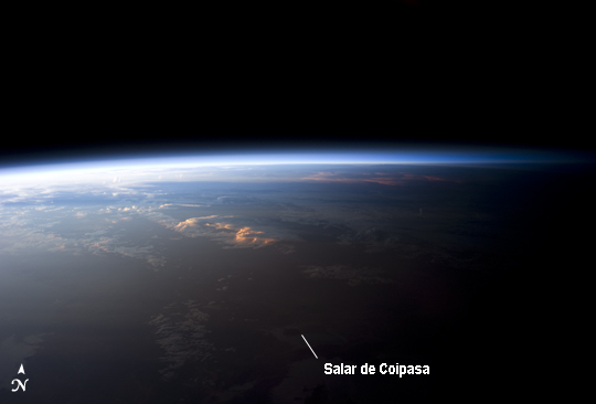
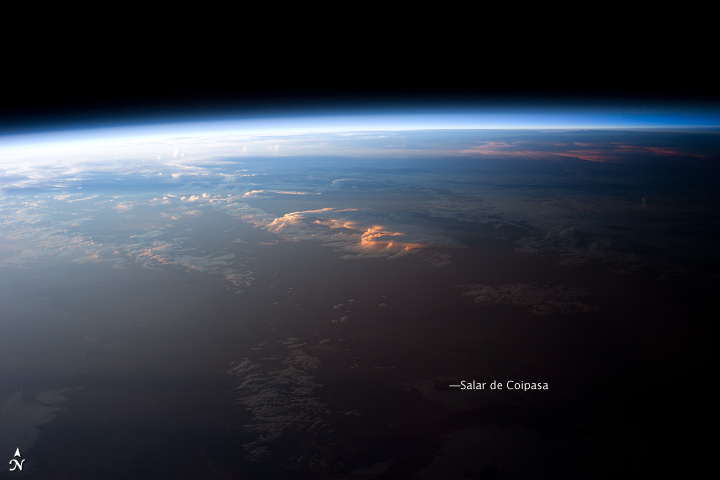
Image Caption: Sunset over Western South America
Astronauts on board the International Space Station see, on average, sixteen sunrises and sunsets during a 24-hour orbital period. Each changeover between day and night on the ground is marked by the terminator, or line separating the sunlit side of the Earth from the side in darkness. While the terminator is conceptualized as a hard boundary--and is frequently presented as such in graphics and visualizations--in reality the boundary between light and dark is diffuse due to scattering of light by the Earth's atmosphere. This zone of diffuse lighting is experienced as dusk or twilight on the ground - while the Sun is no longer visible, some illumination is still present due to light scattering over the local horizon.
The terminator is visible in this astronaut photograph trending across the image from lower left to upper right. This panoramic view across central South America, looking towards the northeast, was acquired at approximately 7:37 PM local time. Layers of the Earth's atmosphere, colored bright white to deep blue, are visible extending across the horizon (or limb). The highest cloud tops have a reddish glow from the direct light of the setting Sun while lower clouds are in twilight. The Salar de Coipasa, a large salt lake in Bolivia, is dimly visible on the night side of the terminator. The salar provides a geographic reference point that allows the location and viewing orientation of the image to be determined.
