ISS026-E-34079
| NASA Photo ID | ISS026-E-34079 |
| Focal Length | 200mm |
| Date taken | 2011.03.14 |
| Time taken | 00:35:13 GMT |
Resolutions offered for this image:
1000 x 664 pixels 540 x 360 pixels 720 x 480 pixels 4256 x 2913 pixels 640 x 438 pixels
1000 x 664 pixels 540 x 360 pixels 720 x 480 pixels 4256 x 2913 pixels 640 x 438 pixels


Cloud masks available for this image:
Spacecraft nadir point: 36.5° N, 144.6° E
Photo center point: 38.0° N, 141.0° E
Photo center point by machine learning:
Photo center point: 38.0° N, 141.0° E
Photo center point by machine learning:
Nadir to Photo Center: West
Spacecraft Altitude: 185 nautical miles (343km)
Country or Geographic Name: | JAPAN |
Features: | SENDAI AREA COAST, ISHIMONAKI, SOMA, KASHIMA |
| Features Found Using Machine Learning: | |
Cloud Cover Percentage: | 75 (51-75)% |
Sun Elevation Angle: | 42° |
Sun Azimuth: | 139° |
Camera: | Nikon D3S Electronic Still Camera |
Focal Length: | 200mm |
Camera Tilt: | 52 degrees |
Format: | 4256E: 4256 x 2832 pixel CMOS sensor, 36.0mm x 23.9mm, total pixels: 12.87 million, Nikon FX format |
Film Exposure: | |
| Additional Information | |
| Width | Height | Annotated | Cropped | Purpose | Links |
|---|---|---|---|---|---|
| 1000 pixels | 664 pixels | No | Yes | Earth From Space collection | Download Image |
| 540 pixels | 360 pixels | Yes | Yes | Earth From Space collection | Download Image |
| 720 pixels | 480 pixels | Yes | Yes | NASA's Earth Observatory web site | Download Image |
| 4256 pixels | 2913 pixels | No | No | Download Image | |
| 640 pixels | 438 pixels | No | No | Download Image |
Download Packaged File
Download a Google Earth KML for this Image
View photo footprint information
Download a GeoTIFF for this photo
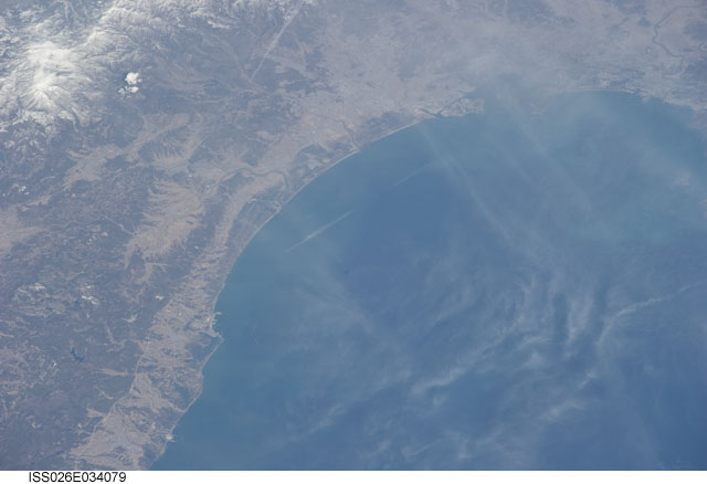
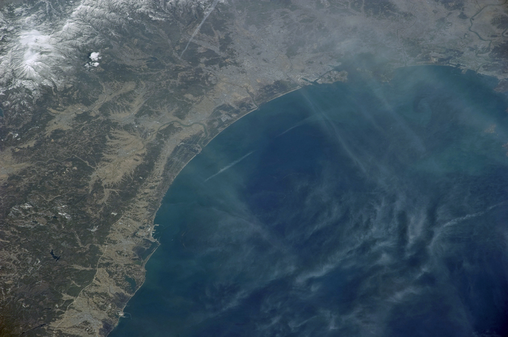
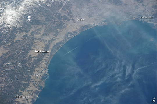
Image Caption: Flooded Coast near Sendai
Through a thin haze of clouds, flooding was still discernible south of Sendai days after the massive earthquake and resulting tsunami that devastated Japan. An Expedition 26 crew member on the International Space Station took this photograph on March 14, 2011.
This image is rotated slightly so north is to the upper right. The metropolitan area of Sendai appears in shades of beige and gray. The coastal plain east and south of the city appears dark due to flood waters sitting on normally dry land. Rivers meandering to the coast blend with the inundated lands now surrounding them.
This photo was taken from an altitude of 215 miles (345 kilometers). Compared to an astronaut photo acquired the previous day, this image appears to have been captured from a higher altitude, but the seeming difference is due to the camera lens.
