ISS026-E-25437
| NASA Photo ID | ISS026-E-25437 |
| Focal Length | 400mm |
| Date taken | 2011.02.10 |
| Time taken | 14:03:16 GMT |
Resolutions offered for this image:
1000 x 664 pixels 540 x 359 pixels 720 x 480 pixels 4288 x 2929 pixels 640 x 437 pixels
1000 x 664 pixels 540 x 359 pixels 720 x 480 pixels 4288 x 2929 pixels 640 x 437 pixels


Spacecraft nadir point: 19.2° N, 96.9° W
Photo center point: 19.0° N, 97.3° W
Photo center point by machine learning:
Photo center point: 19.0° N, 97.3° W
Photo center point by machine learning:
Nadir to Photo Center: Southwest
Spacecraft Altitude: 190 nautical miles (352km)
Country or Geographic Name: | MEXICO |
Features: | PICO DE ORIZABA VOLCANO, LAHAR DEPOSITS, SIERRA NEGRA |
| Features Found Using Machine Learning: | |
Cloud Cover Percentage: | 10 (1-10)% |
Sun Elevation Angle: | 14° |
Sun Azimuth: | 111° |
Camera: | Nikon D2Xs Electronic Still Camera |
Focal Length: | 400mm |
Camera Tilt: | 8 degrees |
Format: | 4288E: 4288 x 2848 pixel CMOS sensor, RGBG imager color filter |
Film Exposure: | |
| Additional Information | |
| Width | Height | Annotated | Cropped | Purpose | Links |
|---|---|---|---|---|---|
| 1000 pixels | 664 pixels | No | Yes | Earth From Space collection | Download Image |
| 540 pixels | 359 pixels | Yes | Yes | Earth From Space collection | Download Image |
| 720 pixels | 480 pixels | Yes | Yes | NASA's Earth Observatory web site | Download Image |
| 4288 pixels | 2929 pixels | No | No | Download Image | |
| 640 pixels | 437 pixels | No | No | Download Image |
Download Packaged File
Download a Google Earth KML for this Image
View photo footprint information
Download a GeoTIFF for this photo
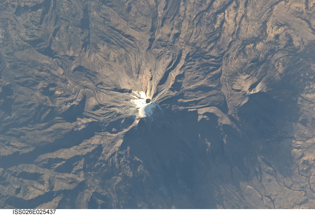
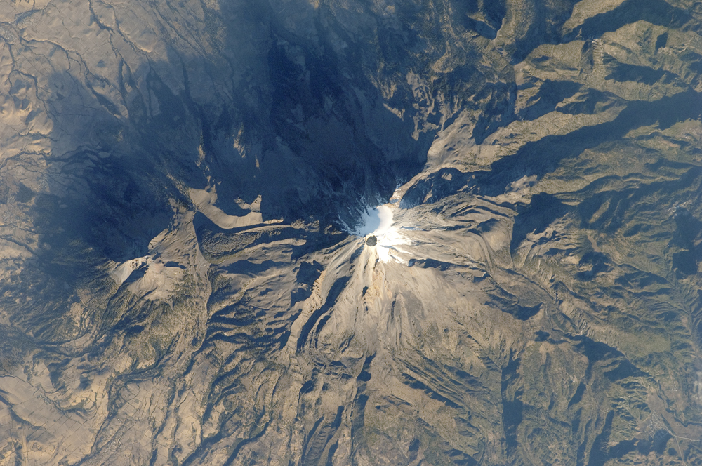
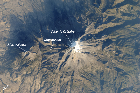
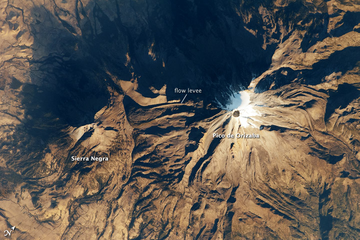
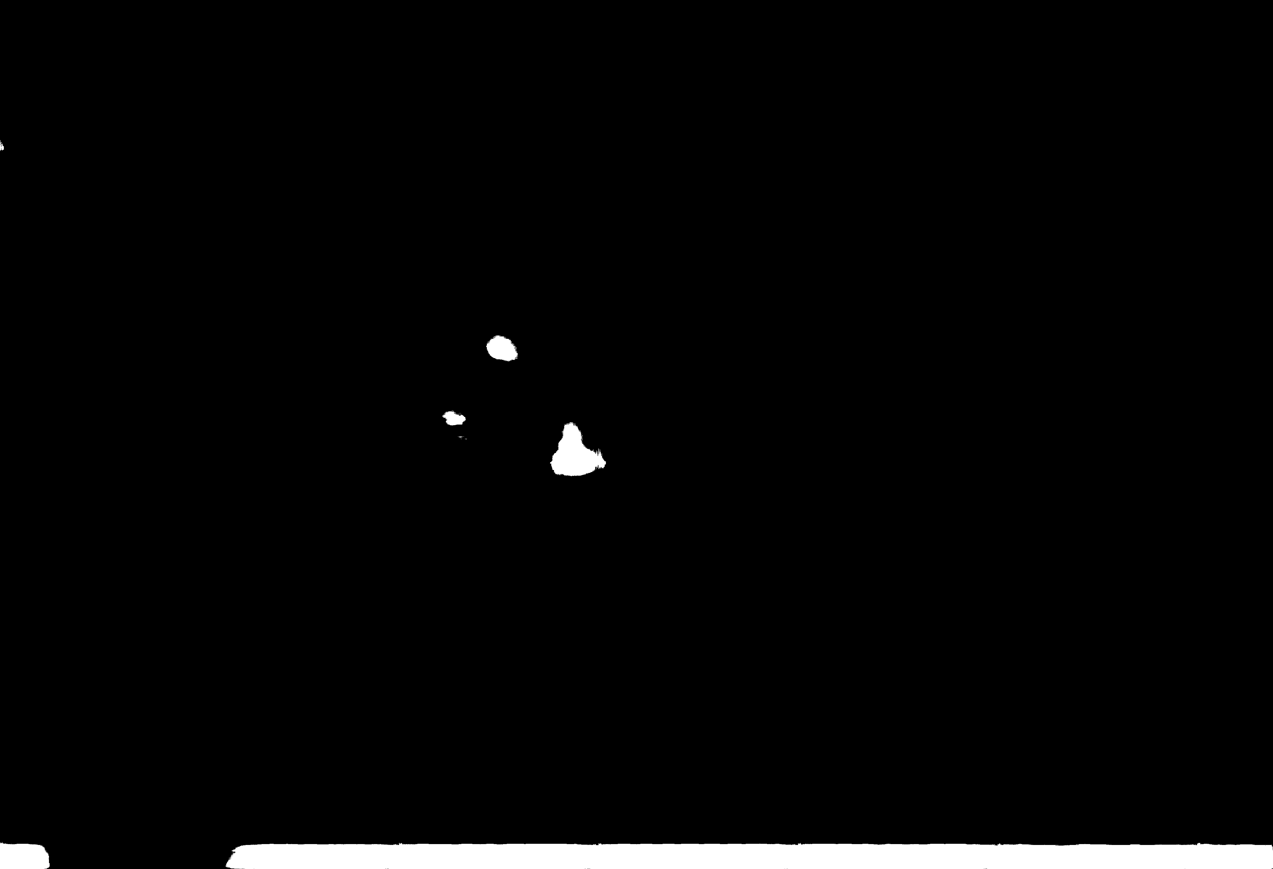
Image Caption: Pico de Orizaba, Mexico
The snow and ice-clad peak of Pico de Orizaba (also known as Citlaltepetl) boasts a summit elevation of 5675 meters (18619 feet) above sea level, making it the highest peak in Mexico and North America's highest volcano. It is also one of three volcanic peaks in Mexico--together with Popocatepetl and Iztaccihuatl-that retain summit glaciers. Pico de Orizaba is part of the Trans-Mexican Volcanic Belt that extends roughly east-west across Mexico. The last recorded eruption took place in 1846; while the volcano is considered dormant at present, geologists continue to investigate the potential hazards associated with a renewal of activity.
Shadows accentuate several features of the Pico de Orizaba stratovolcano visible in this astronaut photograph from the International Space Station. The 300 meter deep summit crater is clearly visible against surrounding ice and snow cover at image center. Several lava flows extend down the flanks of the volcano, made readily visible by prominent cooling ridges along their sides known as flow levees - one of the most clearly visible examples is located on the southwest flank of the cone.
The extinct Sierra Negra volcano to the southwest has a summit elevation of 4640 meters (15,223 feet) above sea level; while not as lofty as Pico de Orizaba, it is also one of Mexico's highest peaks.
