ISS026-E-23526
| NASA Photo ID | ISS026-E-23526 |
| Focal Length | 800mm |
| Date taken | 2011.01.30 |
| Time taken | 09:38:05 GMT |
Resolutions offered for this image:
1000 x 667 pixels 540 x 360 pixels 720 x 480 pixels 4256 x 2913 pixels 640 x 438 pixels
1000 x 667 pixels 540 x 360 pixels 720 x 480 pixels 4256 x 2913 pixels 640 x 438 pixels


Spacecraft nadir point: 12.7° N, 43.4° E
Photo center point: 13.4° N, 41.7° E
Photo center point by machine learning:
Photo center point: 13.4° N, 41.7° E
Photo center point by machine learning:
Nadir to Photo Center: West
Spacecraft Altitude: 190 nautical miles (352km)
Country or Geographic Name: | ERITREA |
Features: | NABRO VOLCANO, LAVA FLOWS, ARUKU |
| Features Found Using Machine Learning: | |
Cloud Cover Percentage: | 10 (1-10)% |
Sun Elevation Angle: | 59° |
Sun Azimuth: | 189° |
Camera: | Nikon D3S Electronic Still Camera |
Focal Length: | 800mm |
Camera Tilt: | 30 degrees |
Format: | 4256E: 4256 x 2832 pixel CMOS sensor, 36.0mm x 23.9mm, total pixels: 12.87 million, Nikon FX format |
Film Exposure: | |
| Additional Information | |
| Width | Height | Annotated | Cropped | Purpose | Links |
|---|---|---|---|---|---|
| 1000 pixels | 667 pixels | No | Yes | Earth From Space collection | Download Image |
| 540 pixels | 360 pixels | Yes | Yes | Earth From Space collection | Download Image |
| 720 pixels | 480 pixels | Yes | Yes | NASA's Earth Observatory web site | Download Image |
| 4256 pixels | 2913 pixels | No | No | Download Image | |
| 640 pixels | 438 pixels | No | No | Download Image |
Download Packaged File
Download a Google Earth KML for this Image
View photo footprint information
Download a GeoTIFF for this photo
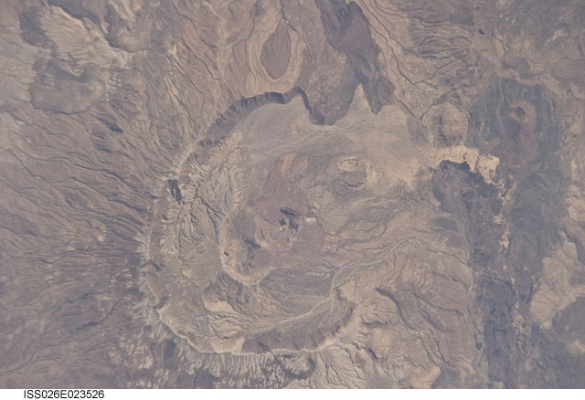
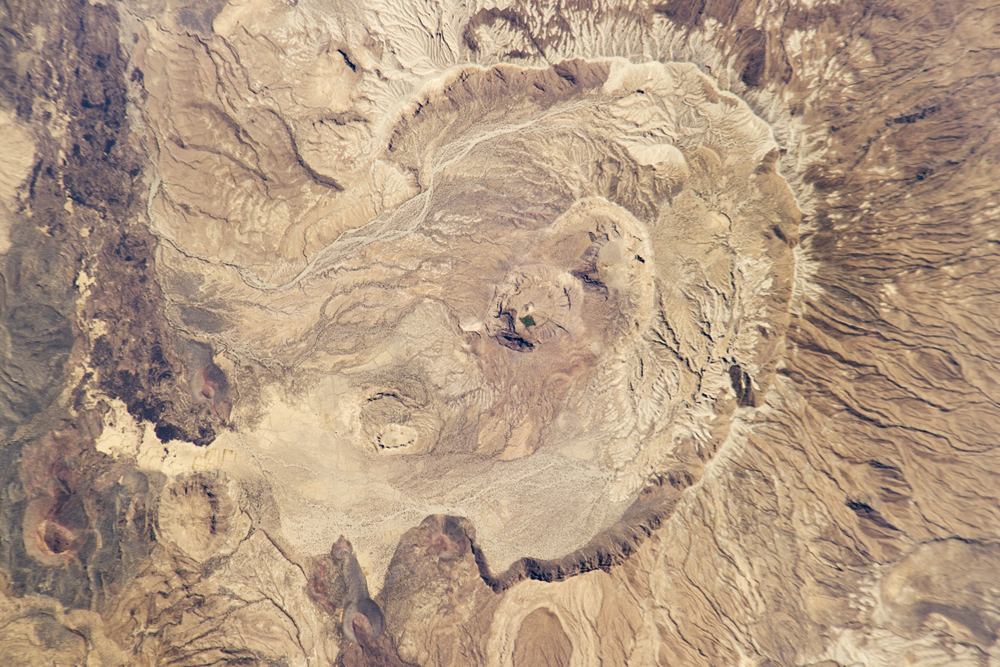
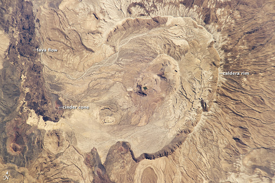
Image Caption: Nabro Volcano Before Eruption
Prior to June 12, 2011, the Nabro volcano in northeast Africa looked like it does in the image above. Then, on the night of June 12, 2011, the stratovolcano erupted for the first time in recorded history. It spewed ash and large amounts of sulfur dioxide gas--the highest levels ever detected from space, according to preliminary estimates from researchers at NASA's Goddard Space Flight Center.
Astronauts on the International Space Station snapped this digital photograph of Nabro in January 2011, when all was still quiet. The horseshoe-shaped caldera stretches 8 kilometers (5 miles) in diameter and opens to the southwest. Two smaller calderas lie within the larger one. Gullies and channels scar the outer flanks, signs of many years of runoff. The inner edge of the caldera has steep cliffs, some as high as 400 meters.
Located in Eritrea near the border with Ethiopia, Nabro is part of larger double-caldera structure with the Mallahle volcano to the southwest. Both volcanoes were built, like Kilimanjaro, from trachyte lavas, and later filled by eruptions of ignimbrite. Research suggests that both calderas may have formed around the same time. The volcanic range has been "virtually undocumented," according to researchers.
As of June 18, 2011, the volcano was still erupting, though less effusively than the during the preceding week. The ash cloud has periodically disrupted air traffic in North Africa and parts of the eastern Mediterranean. Ash plumes were reported as far as the Central African Republic, Israel, and Turkmenistan.
