ISS026-E-13115
| NASA Photo ID | ISS026-E-13115 |
| Focal Length | 32mm |
| Date taken | 2010.12.28 |
| Time taken | 06:48:50 GMT |

Cloud masks available for this image:
Spacecraft nadir point: 26.1° N, 84.5° W
Photo center point: 29.0° N, 82.0° W
Photo center point by machine learning:
Photo center point: 29.0° N, 82.0° W
Photo center point by machine learning:
Nadir to Photo Center: Northeast
Spacecraft Altitude: 188 nautical miles (348km)
Country or Geographic Name: | USA-FLORIDA |
Features: | PAN-NORTH FLORIDA PEN.-SOUTHEAST UNITED STATES REGION AT NIGHT, EARTH LIMB |
| Features Found Using Machine Learning: | PAN- |
Cloud Cover Percentage: | 25 (11-25)% |
Sun Elevation Angle: | -74° |
Sun Azimuth: | 84° |
Camera: | Nikon D3S Electronic Still Camera |
Focal Length: | 32mm |
Camera Tilt: | 51 degrees |
Format: | 4256E: 4256 x 2832 pixel CMOS sensor, 36.0mm x 23.9mm, total pixels: 12.87 million, Nikon FX format |
Film Exposure: | |
| Additional Information | |
| Width | Height | Annotated | Cropped | Purpose | Links |
|---|---|---|---|---|---|
| 4256 pixels | 2913 pixels | No | No | Download Image | |
| 640 pixels | 438 pixels | No | No | Download Image |
Download Packaged File
Download a Google Earth KML for this Image
View photo footprint information
Download a GeoTIFF for this photo
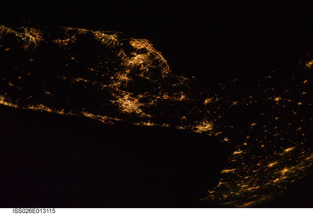
Image Caption: ISS026-E-013115 (28 Dec. 2010) --- From 220 miles above Earth, one of the Expedition 26 crew members used a 32-mm lens to capture this night time image of much of the Florida peninsula. The picture needs to be rotated 90 degrees counter-clockwise to situate north at the top. St. Petersburg, Tampa Bay and Fort Myers can be easily delineated on the Gulf of Mexico (top in the original orientation) side and the spread-out bright lights of the Orlando area appear near frame center. Cape Canaveral and the Kennedy Space Center can also be spotted on the Atlantic side of Florida, with lights of Jacksonville visible further northward.
