ISS026-E-10155
| NASA Photo ID | ISS026-E-10155 |
| Focal Length | 180mm |
| Date taken | 2010.12.14 |
| Time taken | 14:34:42 GMT |
Resolutions offered for this image:
1000 x 688 pixels 540 x 372 pixels 720 x 540 pixels 4256 x 2913 pixels 640 x 438 pixels
1000 x 688 pixels 540 x 372 pixels 720 x 540 pixels 4256 x 2913 pixels 640 x 438 pixels


Cloud masks available for this image:
Spacecraft nadir point: 38.5° N, 124.0° E
Photo center point: 39.4° N, 116.8° E
Photo center point by machine learning: 39.31° N, 116.87° E
Photo center point: 39.4° N, 116.8° E
Photo center point by machine learning: 39.31° N, 116.87° E
Nadir to Photo Center: West
Spacecraft Altitude: 185 nautical miles (343km)

Country or Geographic Name: | CHINA |
Features: | BEIJING, LANGFANG, TIANJIN AT NIGHT |
| Features Found Using Machine Learning: | |
Cloud Cover Percentage: | 10 (1-10)% |
Sun Elevation Angle: | -70° |
Sun Azimuth: | 313° |
Camera: | Nikon D3S Electronic Still Camera |
Focal Length: | 180mm |
Camera Tilt: | High Oblique |
Format: | 4256E: 4256 x 2832 pixel CMOS sensor, 36.0mm x 23.9mm, total pixels: 12.87 million, Nikon FX format |
Film Exposure: | |
| Additional Information | |
| Width | Height | Annotated | Cropped | Purpose | Links |
|---|---|---|---|---|---|
| 1000 pixels | 688 pixels | No | Yes | Earth From Space collection | Download Image |
| 540 pixels | 372 pixels | Yes | Yes | Earth From Space collection | Download Image |
| 720 pixels | 540 pixels | Yes | Yes | NASA's Earth Observatory web site | Download Image |
| 4256 pixels | 2913 pixels | No | No | Download Image | |
| 640 pixels | 438 pixels | No | No | Download Image |
Download Packaged File
Download a Google Earth KML for this Image
View photo footprint information
Download a GeoTIFF for this photo
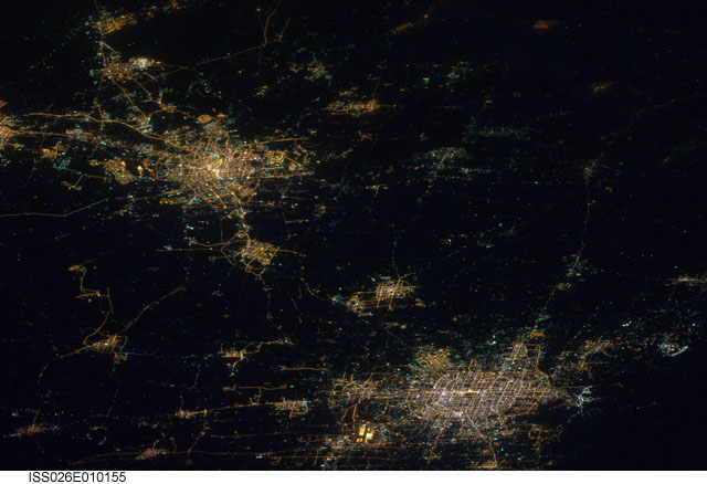
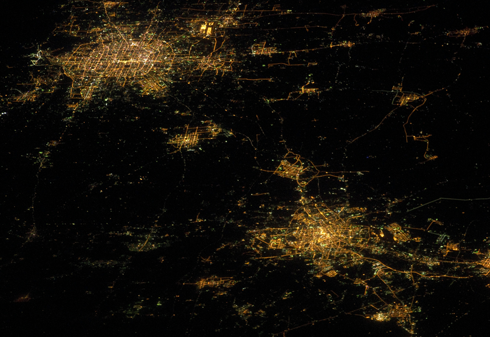
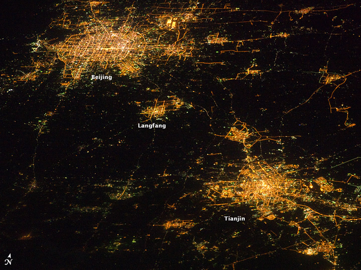
Image Caption: Cities at Night, Northern China
Note: This caption refers to the image versions labeled "NASA's Earth Observatory web site".
Nighttime images have a way of dramatically revealing the amount of land development in metropolitan areas. This astronaut photograph features two of China's most populous cities--Beijing and Tianjin--both in the northeastern part of the country near the Bohai Gulf. The United Nations estimated the 2010 population of the Beijing metropolitan area to be approximately 12 million, with the population of Tianjin estimated at more than 7 million.
The smaller city of Langfang, located midway between Beijing and Tianjin, is also clearly visible, as are several smaller developments to the northeast. The dark regions are mainly agricultural fields, with wheat and corn being the major crops.
Beijing (also known as Peking) is one of the ancient capital cities and the current capital of the People's Republic of China. Its regular grid pattern is clearly visible at image upper left; concentric rings of major roadways around the city have been added as the metropolitan area has expanded. Tianjin is a major trade center linked to seaports on the Bohai Gulf. The city lies along the Grand Canal of China, a major artificial waterway extending southward for 1,176 kilometers (1,103 miles) from Beijing to Hangzhou.
This photograph was acquired by astronauts on the International Space Station (ISS) when it was located approximately 630 kilometers (391 miles) away, over the Yellow Sea near the western coastline of North Korea. The flattened perspective of the urban areas is the result of the viewing angle and distance from the ISS. The city light patterns are very clear, indicating that there was little cloud cover or haze in the region at the time.
