ISS025-E-9858
| NASA Photo ID | ISS025-E-9858 |
| Focal Length | 16mm |
| Date taken | 2010.10.28 |
| Time taken | 23:38:48 GMT |
Resolutions offered for this image:
1000 x 751 pixels 540 x 406 pixels 720 x 480 pixels 4256 x 2913 pixels 640 x 438 pixels
1000 x 751 pixels 540 x 406 pixels 720 x 480 pixels 4256 x 2913 pixels 640 x 438 pixels
Cloud masks available for this image:
Spacecraft nadir point: 22.5° N, 35.1° E
Photo center point: 30.0° N, 30.5° E
Photo center point by machine learning:
Photo center point: 30.0° N, 30.5° E
Photo center point by machine learning:
Nadir to Photo Center: Northwest
Spacecraft Altitude: 186 nautical miles (344km)
Country or Geographic Name: | EGYPT |
Features: | AT NIGHT, NILE RIVER DELTA, CAIRO, NILE RIVER, AIRGLOW, TEL-AVIV, CYPRUS |
| Features Found Using Machine Learning: | |
Cloud Cover Percentage: | 10 (1-10)% |
Sun Elevation Angle: | -57° |
Sun Azimuth: | 80° |
Camera: | Nikon D3S Electronic Still Camera |
Focal Length: | 16mm |
Camera Tilt: | High Oblique |
Format: | 4256E: 4256 x 2832 pixel CMOS sensor, 36.0mm x 23.9mm, total pixels: 12.87 million, Nikon FX format |
Film Exposure: | |
| Additional Information | |
| Width | Height | Annotated | Cropped | Purpose | Links |
|---|---|---|---|---|---|
| 1000 pixels | 751 pixels | No | Yes | Earth From Space collection | Download Image |
| 540 pixels | 406 pixels | Yes | Yes | Earth From Space collection | Download Image |
| 720 pixels | 480 pixels | Yes | Yes | NASA's Earth Observatory web site | Download Image |
| 4256 pixels | 2913 pixels | No | No | Download Image | |
| 640 pixels | 438 pixels | No | No | Download Image |
Download Packaged File
Download a Google Earth KML for this Image
View photo footprint information
Download a GeoTIFF for this photo
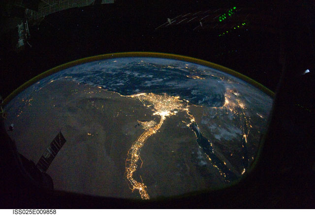
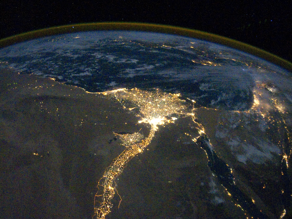
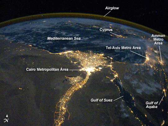
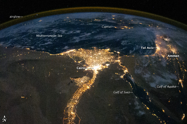
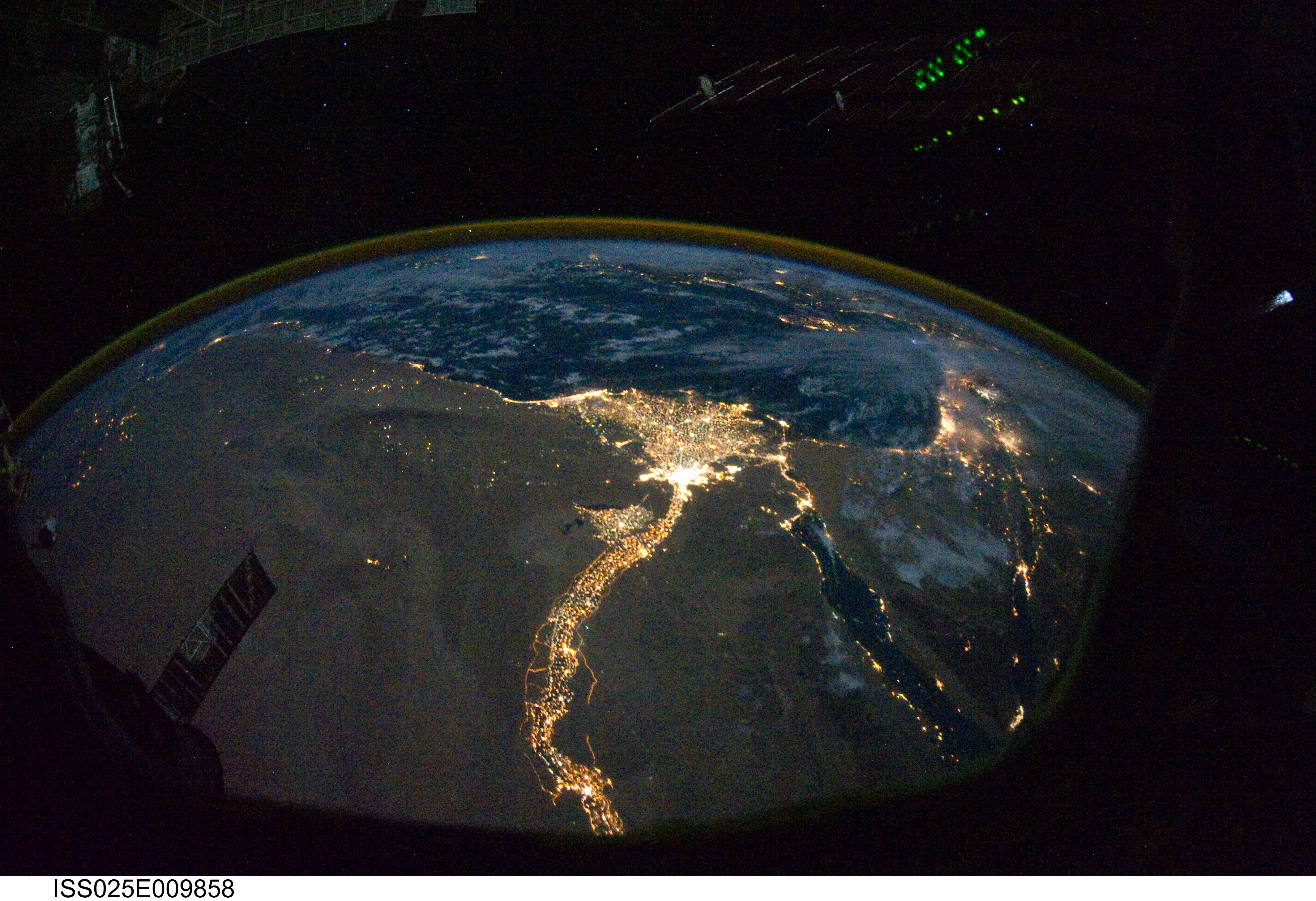
Image Caption: Nile River Delta at Night
One of the fascinating aspects of viewing Earth at night is how well the lights show the distribution of people. In this view of Egypt, we see a population almost completely concentrated along the Nile Valley, just a small percentage of the country's land area.
The Nile River and its delta look like a brilliant, long-stemmed flower in this astronaut photograph of the southeastern Mediterranean Sea, as seen from the International Space Station. The Cairo metropolitan area forms a particularly bright base of the flower. The smaller cities and towns within the Nile Delta tend to be hard to see amidst the dense agricultural vegetation during the day. However, these settled areas and the connecting roads between them become clearly visible at night. Likewise, urbanized regions and infrastructure along the Nile River becomes apparent (see also The Great Bend of Nile, Day & Night.)
Another brightly lit region is visible along the eastern coastline of the Mediterranean--the Tel-Aviv metropolitan area in Israel (image right). To the east of Tel-Aviv lies Amman, Jordan. The two major water bodies that define the western and eastern coastlines of the Sinai Peninsula--the Gulf of Suez and the Gulf of Aqaba--are outlined by lights along their coastlines (image lower right). The city lights of Paphos, Limassol, Larnaca, and Nicosia are visible on the island of Cyprus (image top).
Scattered blue-grey clouds cover the Mediterranean Sea and the Sinai, while much of northeastern Africa is cloud-free. A thin yellow-brown band tracing the Earth's curvature at image top is airglow, a faint band of light emission that results from the interaction of atmospheric atoms and molecules with solar radiation at approximately 100 kilometers (60 miles) altitude.
