ISS024-E-15121
| NASA Photo ID | ISS024-E-15121 |
| Focal Length | 1000mm |
| Date taken | 2010.09.20 |
| Time taken | 23:01:48 GMT |
Resolutions offered for this image:
1000 x 667 pixels 540 x 360 pixels 720 x 480 pixels 6048 x 4147 pixels 640 x 439 pixels
1000 x 667 pixels 540 x 360 pixels 720 x 480 pixels 6048 x 4147 pixels 640 x 439 pixels

Cloud masks available for this image:
Spacecraft nadir point: 40.5° N, 106.8° W
Photo center point: 38.4° N, 112.5° W
Photo center point by machine learning:
Photo center point: 38.4° N, 112.5° W
Photo center point by machine learning:
Nadir to Photo Center: West
Spacecraft Altitude: 190 nautical miles (352km)
Country or Geographic Name: | USA-UTAH |
Features: | TWITCHELL CANYON FIRE, SMOKE PLUMES, TUSHAR MOUNTAINS |
| Features Found Using Machine Learning: | |
Cloud Cover Percentage: | 10 (1-10)% |
Sun Elevation Angle: | 23° |
Sun Azimuth: | 250° |
Camera: | Nikon D3X Electronic Still Camera |
Focal Length: | 1000mm |
Camera Tilt: | High Oblique |
Format: | 6048E: 6048 x 4032 pixel CMOS sensor, 35.9mm x 24.0mm, total pixels: 25.72 million, Nikon FX format |
Film Exposure: | |
| Additional Information | |
| Width | Height | Annotated | Cropped | Purpose | Links |
|---|---|---|---|---|---|
| 1000 pixels | 667 pixels | No | Yes | Earth From Space collection | Download Image |
| 540 pixels | 360 pixels | Yes | Yes | Earth From Space collection | Download Image |
| 720 pixels | 480 pixels | Yes | Yes | NASA's Earth Observatory web site | Download Image |
| 6048 pixels | 4147 pixels | No | No | Download Image | |
| 640 pixels | 439 pixels | No | No | Download Image |
Download Packaged File
Download a Google Earth KML for this Image
View photo footprint information
Download a GeoTIFF for this photo
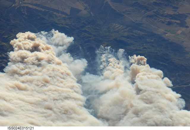
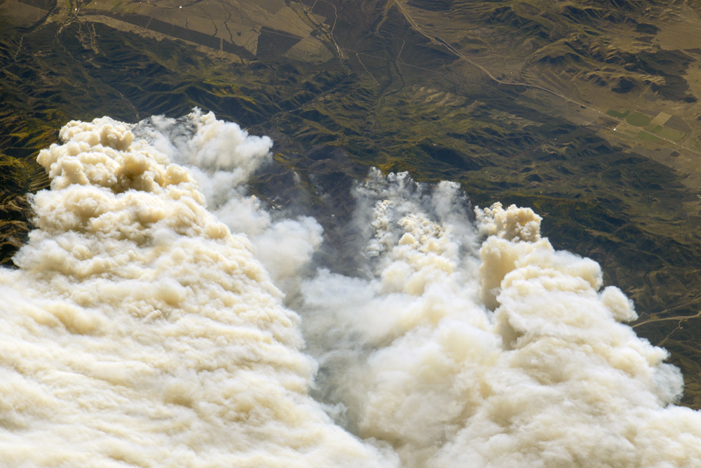
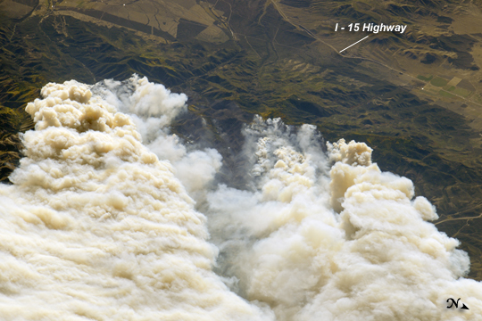
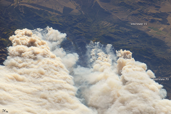
Image Caption: Twitchell Canyon Fire, Central Utah
The Twitchell Canyon Fire, near central Utah's Fishlake National Forest, was reported to cover approximately 13,383 hectares (134 square kilometers, or 33,071 acres) as of September 21, 2010. The crew on the International Space Station (ISS) took this photograph of the smoke plumes generated by fires close to the southwestern edge of the burned area. The fire was started by a lightning strike on July 20, 2010.
The photograph is highly oblique; that is, it was taken at an angle rather than looking straight down towards the Earth's surface (a nadir view). The ISS was located over a point approximately 509 kilometers (316 miles) to the northeast, near the Colorado/Wyoming border, at the time. Southwesterly winds stretched smoke plumes to the northeast.
While the Twitchell Canyon region is sparsely populated, Interstate Highway 15 is visible at the upper right. A MODIS image acquired a day earlier than the astronaut photograph provides a regional view of the fire.
