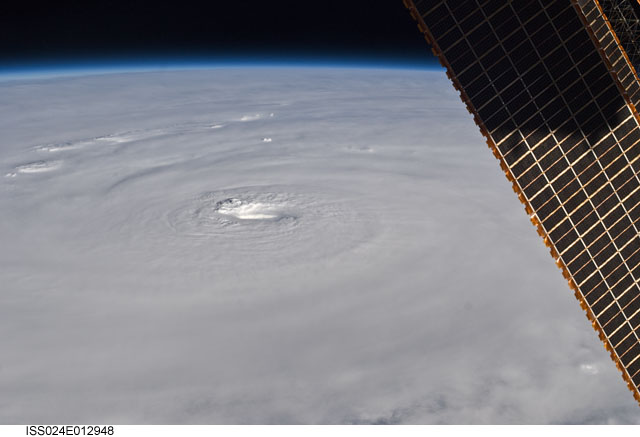
ISS024-E-12948
| NASA Photo ID | ISS024-E-12948 |
| Focal Length | 50mm |
| Date taken | 2010.08.30 |
| Time taken | 21:26:53 GMT |


Spacecraft nadir point: 23.6° N, 72.2° W
Photo center point: 19.5° N, 64.5° W
Photo center point by machine learning:
Photo center point: 19.5° N, 64.5° W
Photo center point by machine learning:
Nadir to Photo Center: Southeast
Spacecraft Altitude: 189 nautical miles (350km)
Country or Geographic Name: | LESSER ANTILLES |
Features: | PAN-HURRICANE EARL, EYE, SPIRAL BANS, MULTILAYERED CLOUDS, ISS |
| Features Found Using Machine Learning: | PAN- |
Cloud Cover Percentage: | 100 (76-100)% |
Sun Elevation Angle: | 22° |
Sun Azimuth: | 270° |
Camera: | Nikon D2Xs Electronic Still Camera |
Focal Length: | 50mm |
Camera Tilt: | High Oblique |
Format: | 4288E: 4288 x 2848 pixel CMOS sensor, RGBG imager color filter |
Film Exposure: | |
| Additional Information | |
| Width | Height | Annotated | Cropped | Purpose | Links |
|---|---|---|---|---|---|
| 4288 pixels | 2929 pixels | No | No | Download Image | |
| 640 pixels | 437 pixels | No | No | Download Image |
Download Packaged File
Download a Google Earth KML for this Image
View photo footprint information
Download a GeoTIFF for this photo
Image Caption: ISS024-E-012948 (30 Aug. 2010) --- Hurricane Earl is featured in this Aug. 30 image photographed by an Expedition 24 crew member on the International Space Station.
