ISS023-E-56842

| NASA Photo ID | ISS023-E-56842 |
| Focal Length | 800mm |
| Date taken | 2010.05.26 |
| Time taken | 08:11:46 GMT |
Resolutions offered for this image:
1000 x 664 pixels 540 x 359 pixels 720 x 480 pixels 6048 x 4147 pixels 640 x 439 pixels
1000 x 664 pixels 540 x 359 pixels 720 x 480 pixels 6048 x 4147 pixels 640 x 439 pixels

Cloud masks available for this image:
Spacecraft nadir point: 48.4° N, 38.4° E
Photo center point: 45.4° N, 35.8° E
Photo center point by machine learning:
Photo center point: 45.4° N, 35.8° E
Photo center point by machine learning:
Nadir to Photo Center: Southwest
Spacecraft Altitude: 182 nautical miles (337km)
Country or Geographic Name: | UKRAINE |
Features: | KAZANTYP PT., LAKE, PENINSULA, SEA OF AZOV, AGR., SHCHOLKINE |
| Features Found Using Machine Learning: | |
Cloud Cover Percentage: | 10 (1-10)% |
Sun Elevation Angle: | 59° |
Sun Azimuth: | 146° |
Camera: | Nikon D3X Electronic Still Camera |
Focal Length: | 800mm |
Camera Tilt: | 53 degrees |
Format: | 6048E: 6048 x 4032 pixel CMOS sensor, 35.9mm x 24.0mm, total pixels: 25.72 million, Nikon FX format |
Film Exposure: | |
| Additional Information | |
| Width | Height | Annotated | Cropped | Purpose | Links |
|---|---|---|---|---|---|
| 1000 pixels | 664 pixels | No | Yes | Earth From Space collection | Download Image |
| 540 pixels | 359 pixels | Yes | Yes | Earth From Space collection | Download Image |
| 720 pixels | 480 pixels | Yes | No | NASA's Earth Observatory web site | Download Image |
| 6048 pixels | 4147 pixels | No | No | Download Image | |
| 640 pixels | 439 pixels | No | No | Download Image |
Download Packaged File
Download a Google Earth KML for this Image
View photo footprint information
Download a GeoTIFF for this photo
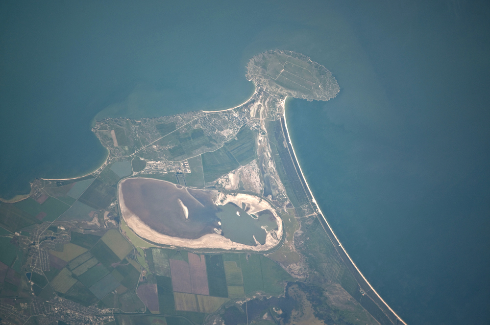
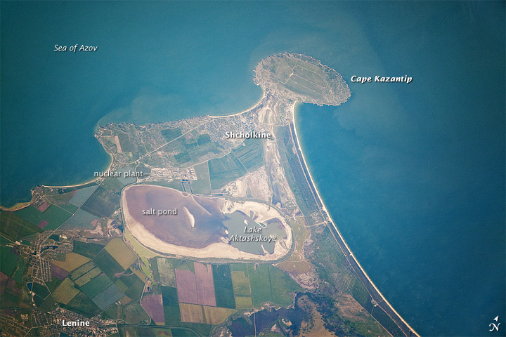
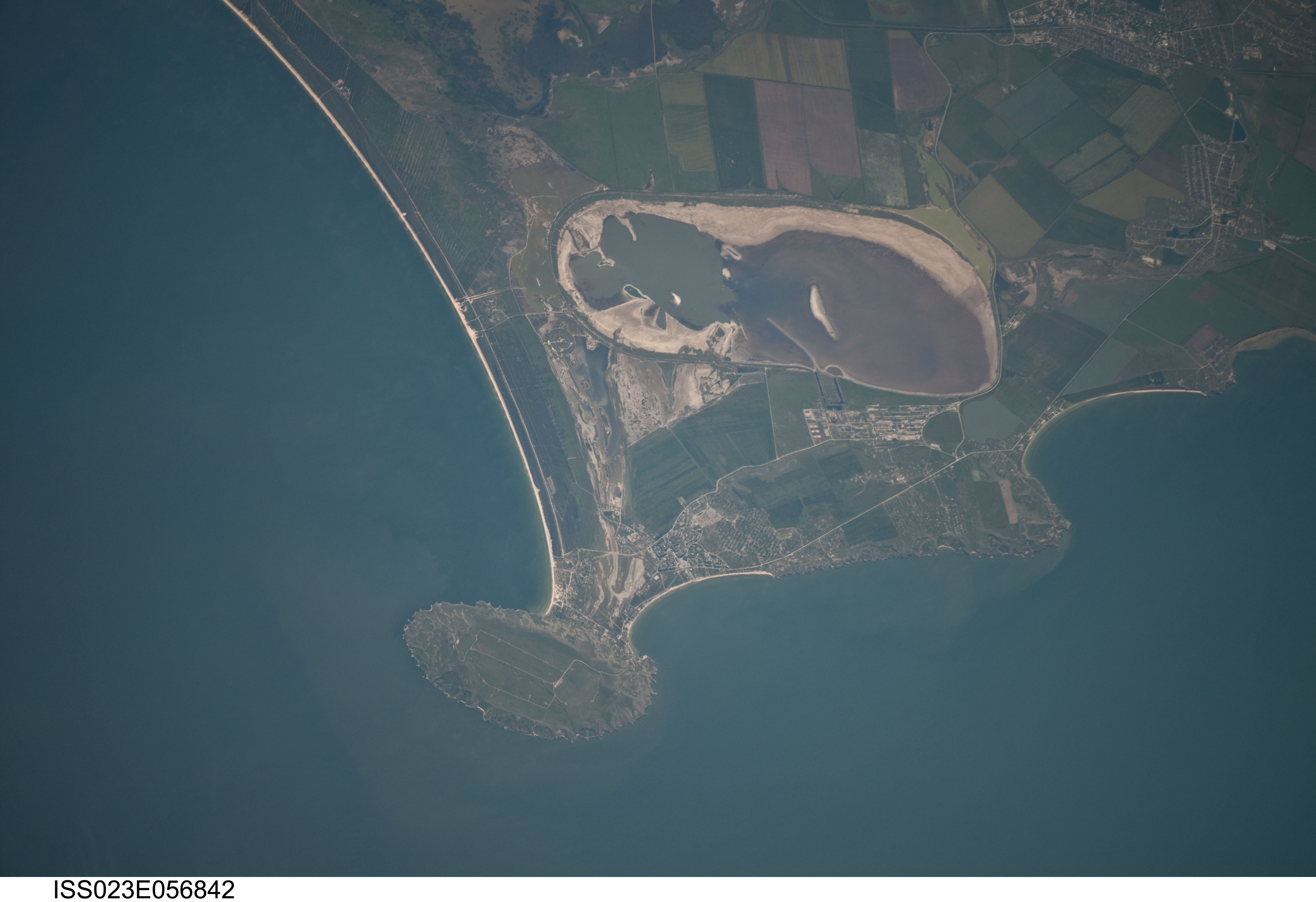
Image Caption: Cape Kazantip, Kerch Peninsula, Southern Sea of Azov, Ukraine
Cape Kazantip is a prominent headland on the Kerch Peninsula, which defines the southern shore of the Sea of Azov and the east extension of the Crimean Peninsula. During the Second World War, German and Soviet forces fought on the Kerch Peninsula, with the line of battle impinging on areas shown at the bottom of the image. Due to its relatively low latitude (45deg N) the Crimea has been the warm holidaying destination for generations of Ukrainians and Russians. Towns in the Kazantip area--Lenine, Shcholkine--offer tourist attractions, ranging from birdwatching to beaches and music festivals.
This detailed astronaut photograph was taken from the International Space Station (ISS) when it was located 400 kilometers (250 miles) to the northeast, but due to the long (800 mm) lens used, the photo includes detailed field patterns and city blocks. Green and brown fields show intensive agricultural activity in the area, and salt ponds are visible at the west end of the shallow Lake Aktashskoye at image center. The distance from the tip of the Cape to the largest local city, Lenine (population ~70,000, image lower left) is only 20 kilometers (12 miles).
Shcholkine, named for a Russian physicist, is a new town built in 1978 to house workers of the planned Crimean nuclear power plant. The partially completed plant was inspected following the Chernobyl disaster of 1986, and was found to be located on a site prone to earthquakes. Further construction was terminated, and the already built structures and construction equipment was abandoned in place. Today, Shcholkine is an increasingly popular tourist destination.
