ISS023-E-35670
| NASA Photo ID | ISS023-E-35670 |
| Focal Length | 800mm |
| Date taken | 2010.05.08 |
| Time taken | 13:30:01 GMT |
Resolutions offered for this image:
1000 x 665 pixels 540 x 359 pixels 720 x 480 pixels 4256 x 2913 pixels 640 x 438 pixels
1000 x 665 pixels 540 x 359 pixels 720 x 480 pixels 4256 x 2913 pixels 640 x 438 pixels
Cloud masks available for this image:
Spacecraft nadir point: 41.9° N, 50.2° E
Photo center point: 40.8° N, 47.1° E
Photo center point by machine learning:
Photo center point: 40.8° N, 47.1° E
Photo center point by machine learning:
Nadir to Photo Center: West
Spacecraft Altitude: 187 nautical miles (346km)
Country or Geographic Name: | AZERBAIJAN |
Features: | KURA R., MINGACEVIR RES., DAM, MTS., AGR. |
| Features Found Using Machine Learning: | |
Cloud Cover Percentage: | 10 (1-10)% |
Sun Elevation Angle: | 23° |
Sun Azimuth: | 272° |
Camera: | Nikon D3S Electronic Still Camera |
Focal Length: | 800mm |
Camera Tilt: | 47 degrees |
Format: | 4256E: 4256 x 2832 pixel CMOS sensor, 36.0mm x 23.9mm, total pixels: 12.87 million, Nikon FX format |
Film Exposure: | |
| Additional Information | |
| Width | Height | Annotated | Cropped | Purpose | Links |
|---|---|---|---|---|---|
| 1000 pixels | 665 pixels | No | Yes | Earth From Space collection | Download Image |
| 540 pixels | 359 pixels | Yes | Yes | Earth From Space collection | Download Image |
| 720 pixels | 480 pixels | Yes | No | NASA's Earth Observatory web site | Download Image |
| 4256 pixels | 2913 pixels | No | No | Download Image | |
| 640 pixels | 438 pixels | No | No | Download Image |
Download Packaged File
Download a Google Earth KML for this Image
View photo footprint information
Download a GeoTIFF for this photo
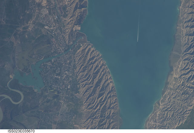
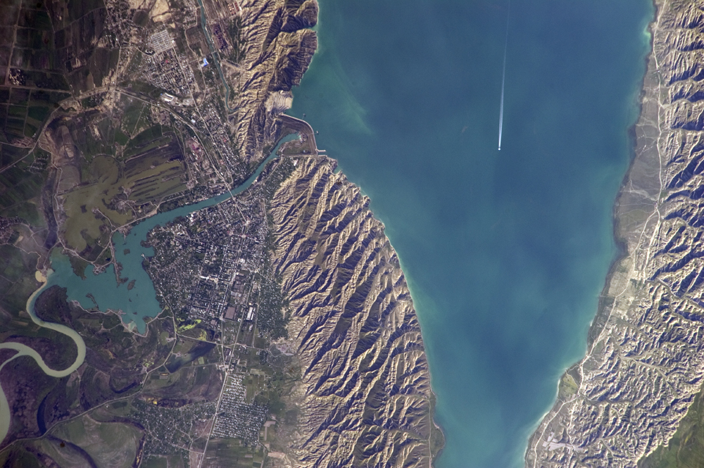
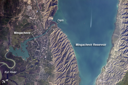
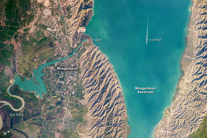
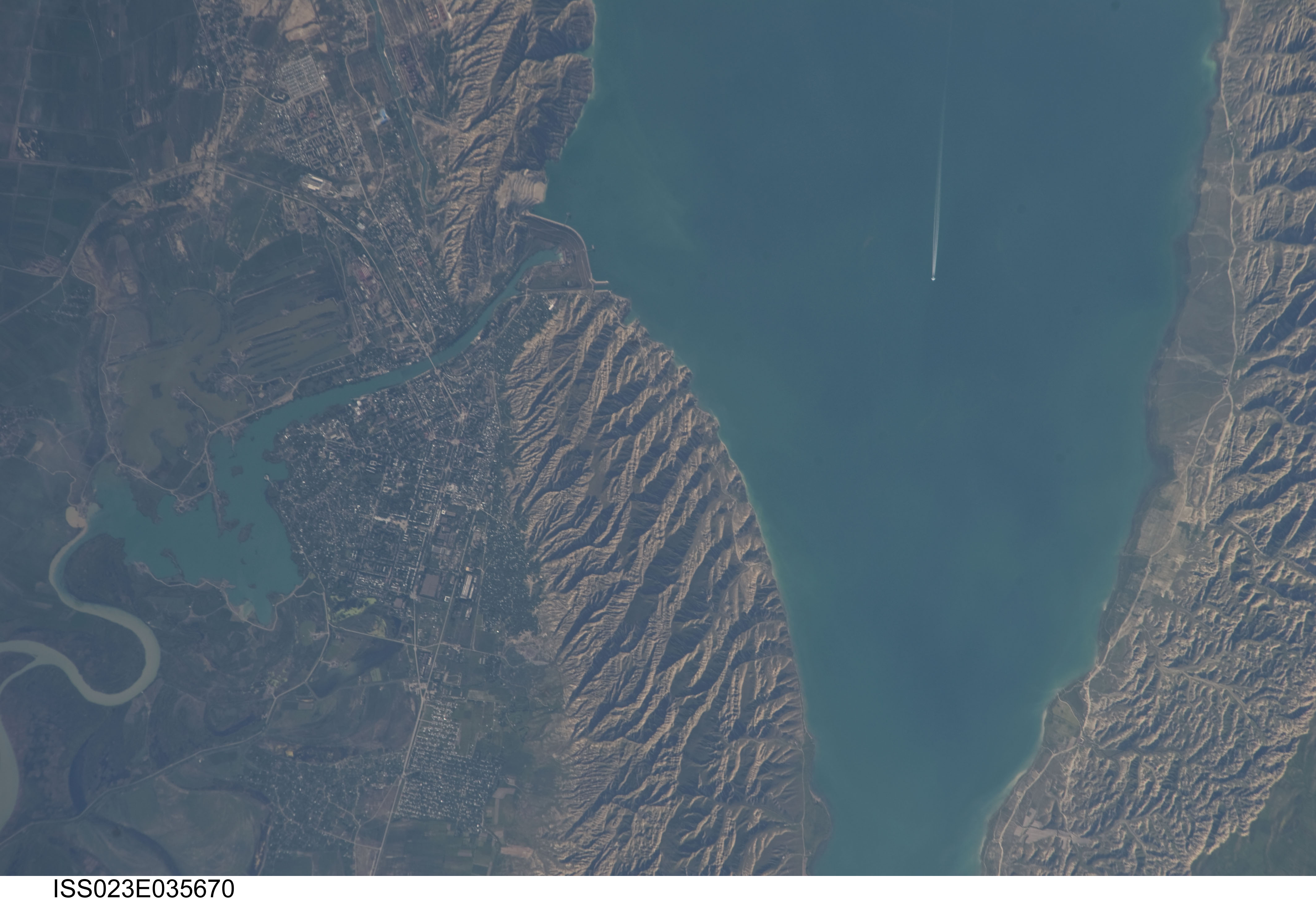
Image Caption: Mingachevir Reservoir, Azerbaijan
This detailed astronaut photograph highlights the southern Mingachevir Reservoir in north-central Azerbaijan. The Mingachevir Reservoir occupies part of the Kura Basin, a topographic depression located between the Greater Caucasus Mountains to the northeast and the Lesser Caucasus Mountains to the southwest. Folded layers of relatively young (less than 5. 3 million years old) sedimentary rock, explosive volcanic products (ash and tuff), and unconsolidated sediments form the gray hills along the northern and southern shorelines of the reservoir (image center and right). Afternoon sun highlights distinctive parallel patterns in the hills that are the result of water and wind erosion of different rock layers exposed at the surface.
The nearby city of Mingachevir (left) is split by the Kur River after it passes through the dam and hydroelectric power station complex at image top center. The current city was built in support of the hydroelectric power station constructed as part of the then-Soviet Union's energy infrastructure for the region. Today, Mingachevir is the fourth-largest city in Azerbaijan (by population), and it has become a cultural and economic center of the country. The reservoir held approximately 15 billion cubic meters of water at the time this image was taken, with a total engineered capacity of 16 billion cubic meters. The width of the reservoir illustrated here is approximately 8 kilometers (5 miles); a jet flying over the reservoir left a contrail midway between the shorelines.
